Someone read one of my blogs about my ratings for the best cities in the world. He then asked me the following: “How would you rate Vancouver? Would it potentially make it on your best-ever list in the future? And what do you think is the reason why it seems to get so much amazing press? From a cursory Google Images search, the downtown looks to me like a whole lot of nondescript glass towers.”
My reply: I’ve long been intrigued by Vancouver, as the city is often ranked quite high as a quality city, which led me to be eager to visit to see for myself.
When I visited, I was disappointed.
As you say, the city has a lot of rather tall, intimidating glass and modernist towers. I did not find much at all in the way of charming walkability or human scale.
It was easy to see that as noted by reports, the city has quite a bit of town center housing, which surely must be good news for town center retailers (and, perhaps, a good amount of town center walking).
But what Vancouver illustrates to me is, in my experience, almost an iron law of cities or neighborhoods: The older the city or neighborhood, the more human-scaled and charming and walkable and romantic it is. The newer the city or neighborhood, the less one finds those elements.
This illustrates that our generation is failing to leave a quality legacy for future generations (in terms of the places we build). I believe this is largely due to two things that emerged in the 20th Century: the Modernist design paradigm for buildings, and our car-dependent society. Because cars consume so much space, it has become nearly impossible to create human-scaled, charming places anymore, as cars don’t allow us to do that. Design for motor vehicles is utterly incompatible with design for charm.
It is a tragic dilemma.
Does Vancouver have the ability to make my best-ever list of cities in the future? I believe that because we have built so many modernist, car-happy (i.e., unlovable and unwalkable) places, most all cities in North America will at some point have a future where such places become so unaffordable to maintain and so disliked that we will set about engaging in a lot of demolition and (hopefully) rebuilding such places to be human-scaled and charmingly traditional.
I fear that such a day is a long way off, however. A great deal of economic misery will be required to motivate us in that transformation and restoration.
In sum, I don’t expect Vancouver to make my best-ever city list in my lifetime.
Disclaimer: opinions expressed are solely my own and do not express the views or opinions of any Board or entity I am a member of.
Introduction
In this document, I recommend measures for safer walking, bicycling, transit, and driving in Greenville.
To begin with, one size does not fit all. That is, Greenville must equitably provide for the full range of lifestyle and travel choices. There are at least three in Greenville County: Town center, suburban, and rural. Land development regulations – including transportation design geometries – need to vary within each of these “transects.” The regulations and specifications for each transect “zone” must be calibrated to maximize the quality of each zone.
Not only is this tailored approach much more equitable than a one-size-fits-all approach, it is also more resilient: The future is likely to be quite different than today, particularly due to likely resource, financial, demographic, energy and climate changes. Creating a full set of community designs will lessen the impact of significant community shifts to new ways of living and getting around, so changes will not be as painful and costly.
In addition, establishing a range of regulatory zones and transportation patterns is more sustainable, politically. Conventionally, the community must engage in endless, angry philosophical battles to determine the most acceptable one-size-fits-all lifestyle and travel preferences (which inevitably means that the regulations and designs must be watered down to a mediocrity that no one likes – as a way to minimize objections). Instead, when lifestyle zones are established (urban, suburban, rural) and both land use regulations and transportation designs are calibrated differently for each lifestyle zone, political battles are minimized and the regulations and designs can be better attuned to the lifestyle in question. You don’t like the restrictive parking regulations we are applying to a town center? Fine. If you prefer less restricted parking rules, you clearly should be opting to live in a more drivable part of the community.
A visual example of transect zones.
Design elements that undercut the objectives of a zone are called Transect Violations. A large strip commercial shopping center with an enormous asphalt parking lot is an example of a transect violation in the Greenville town center.
The walkable zone strives for relatively compact, human-scaled, slower-speed street traffic design. Light fixtures and fences are shorter. Buildings are taller and more likely to mix residences with retail or services. Alignments are more rectilinear, hardscapes typically are emphasized over greenscapes, and landscaping is more formal. Setbacks are smaller. Streets are more narrow and distances between homes and shops are relatively short. Motor vehicle parking is more scarce and more expensive to use. Densities tend to be higher. In the walkable zone, “more is better.” That is, a walkable lifestyle tends to be higher quality when more housing, retail, services, and culture are added. The drivable/bikeable zone seeks to be more spacious, more private, and densely vegetated. Roads are wider and speeds are higher. Buildings are shorter and usually single-use. Motor vehicle parking is more abundant and cheaper to use. Setbacks are larger, as are distances between homes and shops. Densities tend to be lower. In the drivable zone, “more is less.” That is, a drivable lifestyle tends to be lower in quality when more housing, retail, services, and culture are added. The rural conservation zone is focused on preservation and is more isolated. Landscaping is relatively naturalistic. Sidewalks and bus service tends to be absent. Speeds are relatively high. Open space, farming, and pasture tend to be abundant.
Unfortunately, in most American cities – including Greenville — the supply of walkable, compact housing is far short of demand for such housing (which substantially increases the cost). Conversely, there is far more of a supply of drivable, more dispersed housing than the demand for such housing (which was recently exemplified by the fact that suburban housing values suffered significantly more than walkable housing values during the housing crash of the late 2000s). Indeed, communities such as Greenville face a growing housing crisis in the future, as the so-called Millennial generation (those reaching adulthood in 2000) is less interested in the drivable suburban lifestyle than previous generations.
Because supply far exceeds demand for town center housing, the transect zone most in need of improvements and expansion in Greenville are the walkable, compact existing and emerging town centers. Greenville needs to provide substantially more walkable, compact housing in future years to create a balanced housing supply and to increase resilience.
It is essential that the Greenville town center make the pedestrian the design imperative. In the center, the pedestrian, not the bicyclist or car or transit, must be paramount. If we get it right for the pedestrian in the town center, every stakeholder tends to benefit: not just pedestrians, but bicyclists, transit, retail, residential, children, seniors, well-behaved motorists, the disabled, and everyone else.
While this document pertains to recommendations for the Greenville Town Center, the recommendations can easily and quickly be adjusted – as appropriate – for other transect zones found within Greenville.
The key for creating safer intersections, roads, and streets is to move away from the century-long engineering practice of using “forgiving design.”
In the Town Center, it is essential to understand the counterproductive nature of calling for a reduction in traffic congestion or seeking an easing of traffic flow. Both of these measures (which are such a consensus in our society that even cyclists, pedestrian advocates, and transit promoters also counterproductively call for such things) lead to a dangerous oversizing of road/parking/intersection infrastructure, and use of high-speed road geometries. By far, the best way to achieve transportation safety is to design roads and intersections for slower speeds (it is not a coincidence that a growing number of cities are joining the “slow cities” movement. https://www.planetizen.com/node/21630)
And a big part of slower speed transportation design comes from road diets (removing excess travel lanes, as was done on Main St in Greenville), reducing travel lane widths (which can be quickly and inexpensively done whenever streets are re-striped), converting one-way streets back to two-way operation, and shrinking the size and turning radius of intersections.
Far too much space has been allocated to easing car travel and car parking. This has infected our cities with the gigantism disease — a disease that results in much less safety, much less prosperity, much less civic pride, much more sprawl, much less human scale, and much lower quality of life.
In recent years, landmark studies have conclusively determined that Safety In Numbers is an essential strategy for promoting transportation safety. With that in mind, these recommendations include not only measures that directly address transportation safety, but also effectively grows the number of pedestrian, bicycling and transit trips as an indirect and important way to promote travel safety. In other words, recommendations promote pedestrian, bicycle and transit trips that are safe, rewarding, and convenient.
The Health, Safety, and Welfare of Greenville, and the Impact of SCDOT
Cities emerge because their setting – their transportation geography – excels at allowing us to exchange goods, services, and ideas. When healthy and safe, cities are engines of innovation, conviviality, social capital, pride, productivity, prosperity, comfort, and long lives.
To do these things, cities – particularly town centers — require such things as slower and safer speeds, walkability, agglomeration (clustering) economies, compact human scale design, and lifestyle and travel choices.
Like all state departments of transportation, the South Carolina DOT (SCDOT) has a single-minded objective that makes it the enemy of the health of cities. Their sole, one-size-fits-all objective is to maximize the speed of the maximum number of motor vehicles. This is a recipe for the destruction of cities, as this objective creates excessive and dangerous speeds, disperses and isolates the city and its residents, destroys human scale, and eliminates lifestyle and travel choices.
The first order of business in modifying its roads to be conducive to city health, safety and welfare, therefore, is for Greenville to take over ownership and maintenance of the many roads in the Greenville town center that are owned by SCDOT.
Accessibility, Not Mobility
Cities – particularly healthy, quality cities — tend to have relatively poor vehicle mobility (due to congestion), but are economically prosperous due to excellent accessibility (activities are clustered together and there are many travel options). To promote economic competitiveness, then, accessibility trumps mobility.
Traffic congestion is therefore not an impediment to economic activity as long as development patterns minimize the amount of driving needed to reach destinations, and that travelers have transportation options to choose from.
Roadway level of service is a less important indicator of transport system performance than average per-capita commute travel time and total per-capita transportation expenditures. Compact development that results in more accessible destinations are the best way to improve transportation and increase economic productivity, because they reduce the average distance between destinations and therefore total travel costs. Conversely, efforts to reduce congestion by, for example, widening roads or intersections, provide little (or negative) economic benefit overall because they reduce overall accessibility in a community, and induces low-density development patterns that do not pay their own way in tax revenue generated.
While it was true that a century ago, providing or expanding road infrastructure was economically beneficial, continuing to do so today suffers so much from diminishing returns that most all road infrastructure expansion results in severe negative economic impact.
In sum, transportation should be evaluated based on accessibility rather than mobility.
Traffic engineer Ian Lockwood highlights a key concept for bicycle, pedestrian, and transit advocates. Current U.S. traffic engineering culture pursues greater mobility, i.e. how fast someone can get between places. Lockwood says we should focus on accessibility instead. In doing so, we’d improve transportation options.
The fundamental purpose of a transportation system is to provide people with comfortable access to what we want, in a short amount of time. Whether or not we use motor vehicles to accomplish this access, is a secondary concern. In fact, energy independence would be best served if we used motorized vehicles as little as possible. Measuring convenient human access in terms of the speed of motor vehicles is indirect and counterproductive. This is because transportation planners often minimize transportation choices in order to reduce delays per vehicle mile traveled (VMT) — for example by shortening signal light durations, removing pedestrian crosswalks, and minimizing bike lanes. While increasing vehicular mobility, these measures reduce the safety and convenience enjoyed by pedestrians and cyclists.
A destination can be considered highly accessible if it can easily be reached by the full range of transportation choices. Town centers tend to be highly accessible since it is easy to reach by foot, by bicycle, by transit, and by car. By contrast, a large office complex in a suburb has poor accessibility because it can typically only be reached easily by car.
Accessibility is an important objective, since essential destinations, when they feature good accessibility, can be enjoyed by all citizens — including children, seniors, the handicapped, the poor and others without access to a car — rather than being something that can only be reached by those with the use of a car.
High accessibility is therefore inclusive and community-building. Low accessibility is exclusive and isolating.
Imagine an urban street grid completely dominated by cyclists and pedestrians, with many nearby destinations, and a few vehicles wending their way through the crowd at 3 mph. Such an area would generate a poor “mobility” score, even though it serves many people with quick, convenient errands, while consuming minimal energy.
If the fundamental goal of a transportation system is happy vehicles, then striving for mobility and reduced congestion are appropriate. However, if the fundamental goal is happy people and a healthy city, we must seek accessibility.
Convert One-Way Streets back to Two-Way Operation
One-way streets increase speeding, increase inattentive driving; increase motorist impatience; make streets less conducive to residential and retail (as well as discouraging bicycling and walking); make newcomers more likely to get lost; increase motorist aggravation; increase motorist travel distances (which increases GHG emissions and fuel consumption); and make dangerous wrong-way travel more likely.
According to one researcher, “One of the worst things that happened in a lot of American cities was the implementation of a one-way street network in downtown areas that created corridors for moving in and out of the city as rapidly as possible. Because of the glaring, significant problems associated with one-way streets, a growing number of cities throughout the nation are converting one-way streets in their town center back to their original two-way operation.
Stroads and the Maximum Number of Lanes
According to traffic engineer Chuck Marohn, a “stroad” tries and fails to combine two types of motor vehicle routes. A stroad tries to be a street — which Marohn describes as a “complex environment where life in the city happens.” A place with pedestrians, motor vehicles, buildings close to the sidewalk for easy accessibility, many entrances and exits to and from the street, a place where a high level of exchange of goods and services occurs, and a place for temporary parking and delivery vehicles.
The stroad also tries to be a road, which Marohn describes as a “high-speed connection between two places” with wide lanes, almost always an excessive number of travel lanes and turn lanes, and limited entrances and exits. Marohn finds that stroads do not function well as either a street or a road. In that sense, Marohn calls a stroad the “futon of roadways,” in the sense that like a stroad, a futon does a poor job in trying to be a bed as well as a sofa. According to Marohn, the problem with stroads is that engineering codes tend to emphasize speed and traffic flow rather than safety, so that stroads try to be “all things to all people” but end up failing in every way as a result.
Greenville suffers from an extremely large number of stroads within its town center. For the town center to provide safe travel for pedestrians, bicyclists, transit users, and passenger motor vehicles, each of these stroads must be redesigned to become a street – that is, a street conducive to a healthy town center. It is likely that the following stroads in town center Greenville will remain stroads as long as they are owned by SCDOT: Augusta Ave, Peter Hollis Blvd, McDaniel Ave, Academy St, Stone Ave, Wade Hampton Blvd, Buncombe St, Rutherford St, Richardson St, Townes St, Poinsett Hwy, Pleasantburg Dr, Laurens Rd, Mills Ave,
Church St, Butler Ave, Washington St, North St, and College St.
Healthy town centers should never have roads that exceed three lanes in size, as exemplified by town center Main Street in Greenville. A larger number of lanes creates severe safety problems for pedestrians, bicyclists, and transit users, increases motor vehicle emissions, increases average vehicle speeds, promotes “jackrabbit” driving, harms small-scale retail and residential, fails to pay its own way regarding tax revenue, degrades nearby neighborhoods, and not only fails to eliminate motor vehicle congestion but actually increases the scale of congestion.
Greenville must incrementally road diet the several stroads within the town center, as was done for town center Main Street. One of the best ways to do this is to replace curbside travel lanes with on-street parking – although in many cases, excessive travel lands and turn lanes can simply be removed without the need to replace them with parking. Road diets are most affordable when done as part of the periodic restriping of a road. The easiest and therefore most common form of road diet is a conversion from four lanes to three.
Greenville must also incrementally diet oversized intersections by eliminating the second left turn at double-left turn intersections.
Vision Zero: The Five (Ineffective) Warnings
This laudable “Vision Zero” program strives for zero traffic deaths or serious traffic injuries. However, nearly all American cities which adopt this important goal engage in the same old ineffective song and dance. They repeatedly use the Five Warnings: Warning signs, Warning lights, Warning education (traffic safety education is a form of victim-blaming), Warning paint, and Warning enforcement to promote safety. Such campaigns border are patronizing and profoundly ineffective in improving safety. They are used repeatedly by elected officials, however, because they are a low-cost, politically easy way to reduce complaints from citizens.
Note that the Five Warnings were, initially, meaningfully improving safety when first used several decades ago. But they have been so over-used over the past century that they now suffer from severe diminishing returns. In part because they contribute to information overload by being overused, which makes them extremely likely to be disregarded.
After a century of using these ineffective “warning” tools for safety, roadways in cities such as Greenville are more dangerous than ever. We must be serious about achieving “Vision Zero,” rather than simply being politically expedient. Greenville can show it is serious about transportation safety by designing our streets and intersections to obligate motorists to drive more slowly and more attentively. It is long past time to deemphasize The Five Warnings in favor of physically redesigning our streets to obligate safe, attentive speeds. Only then will we make meaningful progress in improving safety for walking, bicycling, transit, and driving.
Parking Reforms
Abundant, free parking provided for by the conventional land development code parking requirements invites people to drive a car alone when making trips instead of walking, bicycling, car-pooling or using transit, because the trip by car becomes more convenient and cost-free. In addition, large surface parking lots take up a large amount of valuable city land that could be better used for retail, office, civic, or plaza uses. Furthermore, surface parking aggravates the urban “heat island effect,” not to mention stormwater management problems, and makes life more dangerous, more unpleasant, less interesting, less vibrant and less convenient for people walking, bicycling, or using transit.
Required parking lowers city density and land values. Onerously high parking requirements provide a competitive advantage to the suburbs over downtown areas, since the land-rich suburbs allow a developer to more cheaply meet high parking requirements. The parking requirements, in this way, encourage sprawl.
Many cities are now reducing their required parking space standards based on these concerns, and the fact that the required supply of parking often far exceeds the demand, with the exception of the few major shopping days each year. But even during peak periods, a study in the Seattle region found that the parking supply for offices was 36 percent higher than average peak demand.
Today, it is typical to provide parking for the “20th busiest hour of use, but Donald Shoup notes that this leaves at least half of a shopping center’s parking vacant for at least 40 percent of the year. In Texas and California, office and shopping developments typically have twice as much parking as they need. On average, required parking supply exceeds demand by 16 to 63 percent.
Creating an upper limit on the number of parking spaces that can be provided on a site is an increasingly popular and straightforward way to ensure that excessive parking is not provided. By setting an upper limit, the standard allows the provision of parking to be based more on what the developer sees as the market demand for parking. It seems reasonable to expect that a developer will not “cut her or his own throat” by providing too few parking spaces. Most have clear incentives to provide enough parking to ensure successful business conditions.
Greensville must conduct an annual inventory of the number of parking spaces in the town center, and couple that with a goal to incrementally reduce that number. Parking in the Greenville town center should be more efficiently provided by generously allowing the sharing of parking, fee-in-lieu parking, and leased parking (public ownership of parking).
Parking close to a destination is important only when the place is dull. If the destination is exciting, people are willing to walk great distances to get to it. And the more parking provided near the destination, the less interesting the place becomes.
Recommended Parking Reforms:
Require that new residential projects unbundle the price of parking from the price of housing.
Convert minimum parking requirements to a maximum number of allowed spaces. This in effect creates an exemption from being required to provide parking. The decision to provide sufficient parking is left to the property owner or business.
Require relatively large businesses to offer a parking cash-out program for employees. Cash-out programs are examples of how walking, bicycling, and transit can be made more advantageous than driving (see section below).
Create incentives and remove obstacles to convert town center surface parking to buildings. This is particularly important for parking that fronts public sidewalks.
Expand the ease at which developments or businesses can share parking spaces – particularly when hours of operation are offset.
Provide Greenville-sponsored town center parking that can be leased to businesses or residences that need parking space.
Modest Turning Radius
A large turning radius at a street corner reduces safety for pedestrians and bicyclists because a larger radius: (1) increases the crossing distance for pedestrians and bicyclists at intersections, thereby increasing crossing time and exposure to motor vehicles; and (2) encourages faster, more dangerous vehicle turning speeds and “rolling stops” at intersections.
Designing street corners with smaller turning radii recognizes that the vast majority of vehicles on neighborhood streets (the “reasonably expected” vehicles) are small, slow-speed vehicles. Larger radii, by contrast, take a “worst-case scenario” approach that designs for the extremely rare large or high-speed vehicle. Such an overdesigned street results in higher vehicle speeds, less pedestrian and bicycle travel, and less livable neighborhoods.
Because large radii encourage higher speeds by frequent users of the street (small, slow-speed vehicles) while solving some problems of the rare large and higher speed vehicle, any safety benefits derived from the environment designed for the rare vehicle are overwhelmed by the safety problems created by the frequent vehicle. Overall, there is a decline in net neighborhood safety.
Minimize intersection crosswalk widths by minimizing turning radii, so that motor vehicle turning speeds are less than 20 miles per hour on left turns and less than 10 miles per hour on right turns, and so that the width of the crosswalk is no more than 48 feet.
Similarly, a larger curb turning radius at a parking area ingress and egress point allows vehicles to negotiate a turn rapidly, whereas a smaller radius forces a vehicle to slow down. Traffic engineers prefer a larger radius for vehicle convenience and curb protection, but such a radius makes life more inconvenient and dangerous for pedestrians.
On-Street Parking
On-street parking provides several benefits. It buffers pedestrians from moving vehicle traffic, thereby attracting pedestrians to the area. This attractiveness (and the convenient parking provided) becomes an effective means of retaining and attracting businesses — especially in the town center. In addition, on-street parking usually reduces the number and width of travel lanes, thereby providing several traffic calming benefits such as slower vehicle speeds and increased ease of crossing streets by pedestrians. Slower speeds reduce the number and severity of traffic accidents — in part by making motorists more alert to pedestrians. On-street parking also reduces the need for large parking lots.
By contrast, off-street surface parking and first-floor parking in a parking garage create “gap tooth” dead zones that detract from the urban vibrancy so attractive to residents and visitors.
Greenville has several blocks in the town center than can benefit from the installation of on-street parking. As Donald Shoup recommends, this parking must be priced, should be dynamically priced to reflect change in demand during the day, and should be priced to achieve an 80 percent usage rate on a block face. The parking revenue, according to Shoup, should be dedicated for use on the block where the parking revenue derives from.
Turn Lanes and Slip Lanes
Turn lanes and slip lanes induce excessive motorist turning movement speeds and dangerously inattentive turns. Such lanes – particularly right turn lanes and right-turn slip lanes – tend to be inappropriate for town centers, as they significantly enlarge the size of intersections, which destroys the essential need to create a slower, human-scaled sense of place that only relatively small intersections can provide. Turn lanes make pedestrian crossings exceptionally dangerous due to the higher motor vehicle speeds, the inattentiveness induced in drivers, and the significant increase in intersection crossing distance.
For a town center to be healthy for retail and all forms of travel, safe, attentive motor vehicle travel is essential, and a “park once” environment must be created. Town center Greenville, to become a great city, must be exceptionally convenient, safe, convivial, and rewarding for walking. Such a walking environment is the key for creating what the town center must have: the Park Once environment.
Crosswalks
Crosswalks should be clearly visible at all intersections on busy streets. Bricked crosswalks, with white street bands to allow the driver to better see the walk, should be used when traffic calming is the intended benefit. The brick provides texture that alerts the driver, the next time she or he drives through the area, to be cautious. The bricks also make the crosswalk more visible.
It is important that crosswalks be as short as possible for pedestrian safety. Often, this is done with landscaped bulb-outs, raised center medians, on-street parking, and road or intersection diets.
Double-Left Turn Lanes
Double left-turn lanes should not be used in Greenville. Conventional traffic engineers incorrectly claim that such intersection “improvements” will reduce greenhouse gas emissions by reducing congestion.
Instead, double-left turn lanes increase emissions and reduce pedestrian and bicyclist trips. Double-left turn lanes have been shown to be counterproductive even if we are just looking at car capacity at an intersection. Adding a second left-turn lane suffers significantly from diminishing returns. A double-left turn does not double the left turn capacity. Why? By significantly increasing the crosswalk distance, the walk cycle must be so long that intersection capacity/efficiency (for cars) is dramatically reduced.
By creating excessive asphalt width for motorized vehicle travel, double-left turns (like dedicated right-turn lanes or slip lanes) induce excessive motor vehicle turning speeds, and a dangerous level of motorist inattentiveness.
The enormous size and relatively high motor vehicle speeds induced by a double-left turn intersection creates dangerous and intimidating conditions for bicyclists and pedestrians, which substantially reduces the number of such trips and increases the number of traffic injuries and fatalities.
Double-left turn lanes destroy human scale and a sense of place. A double-left turn lane intersection will never feel like a place to hang out because it vastly exceeds human scale. These over-sized intersections are so hostile that they obligate property owners at each of the four corners of the intersection to pull back from the intersection with massive setbacks, large asphalt parking lots, and car-centric land uses that can tolerate such an unpleasant atmosphere (such as a gas station). This sort of deadening creates a area of apparent abandonment, and is the antithesis of what Greenville needs for health.
Ultimately the double-left turn intersection fails to induce nearby land uses that will generate tax revenues sufficient to make this part of the city self-supporting. It becomes an on-going financial liability that will forever drain substantial dollars from the city budget
Michael Ronkin, former bicycle/pedestrian coordinator for the State of Oregon, adds that double-left turn lanes are an abomination. He adds that “they are a sign of failure: failure to provide enough street connectivity. Without enough street connectivity, intersections must be gigantic so they can accommodate all the extra turns the motorist must make as they drive out of their way and circle back to their intended destination.
Greenville must enact a moratorium on the construction of new intersection double-left turn lanes and eventually remove existing double-left turn configurations (unless they are necessary to avoid excessive congestion caused by a road diet).
Road Design Profoundly Induces Undesirable Land Use
It appears that Greenville believes that street design occurs in a vacuum. That road design does not shape land uses adjacent to the road or in the region. This view, to the extent that it exists, is mistaken. When Greenville or Greenville County add or maintain excessive numbers of travel lanes (ie, widen a road or keeps a road at an excessive width), land uses adjacent to the road become much less hospitable to residences or retail due to the hostile, noisy, high-speed nature of the newly widened road. Residential property values drop catastrophically when near a noisy, dangerous road, which leads to abandonment and a significant decline in property tax revenue. Indeed, overly large roads are a Ponzi Scheme, as initial assumptions about increased wealth due to the wider road instead lead to lower-density design on and near the roadway becoming a severe tax liability, as such development utterly fails to pay its own way in terms of the relatively meager tax revenue it generates compared to the relatively high need for services and infrastructure it demands.
Reform Transportation Design Construction Standards
Greenville transportation design construction standards specify the dimensions and geometries of city street and intersection design. Because these standards tend to promote convenient, high-speed car travel, they substantially undermine several important Greenville objectives, such as promoting safe bicycle, pedestrian, and motor vehicle safety, and increasing the number of bicycling and walking trips. In particular, “forgiving” street design should be eliminated.
Create More Equity in Transportation Funding
To increase transportation funding equity, more effectively achieve Greenville transportation and quality of life objectives, and diversify funding, establish or enhance one or more of the following: (1) a Vehicle Miles Traveled fee; (2) a more comprehensive market-based priced parking program; (3) priced roads; (4) pay-at-the-pump car insurance; (5) weight-based vehicle fees; (6) gas taxes; (7) mileage-based registration fee; and (8) a mileage-based emission fee. If possible, make such new taxes/fees revenue neutral by reducing or eliminating other fees/taxes when the new user fee is instituted.
Promote Affordable Housing with Land Use Policies
Increase affordable housing by creating land use patterns that reduce the number of cars a household must own. Ease restrictions on accessory dwelling units, mixed-use, and higher occupancy limits. Require new development to unbundle the price of parking from the price of housing. Unbundling is another example of a program that makes a walking and bicycling lifestyle more advantageous than driving (see section below).
Minimize the Size of Service Vehicles
Keep service vehicles in Greenville relatively small so that large vehicles (buses, fire trucks) don’t obligate engineers to design street dimensions to the point of over-sizing such dimensions. Greenville needs to incrementally replace over-sized service vehicles with smaller vehicles in future years.
Designing for the infrequent large fire truck may, on balance, be more harmful than helpful because it may encourage improper travel behavior by the more frequent users of neighborhood streets. For example, larger trucks often result in the construction of larger turning radii, yet the benefits obtained by the rare truck are outweighed by the frequent passenger car, which is encouraged to drive faster due to the larger radii (Motorists tend to travel at speeds they feel safe at, and a street designed for safety at high speeds thereby result in higher average travel speeds.) Faster vehicle travel discourages travel by pedestrians and bicyclists, who feel less safe with the higher speed traffic. In addition, the higher average speeds make the neighborhood less livable because the neighborhood not only sees a restriction in travel choice but also suffers from ambient noise level increases.
Designing for “possible” uses such as large trucks, instead of “reasonably expected uses” such as cars, leads to worst-case scenario design — not a proper way to design a livable or safe neighborhood.
Traffic Calming
Throughout history, streets have provided not only a place for vehicle travel, but also a place for walking, socializing, business transactions, and recreation. It has only been since the 1940s that streets have been given over almost entirely to motor vehicles. Planners have found that restoring the historical sharing of street space for several public uses — not just for high-speed motor vehicle travel — is critical to achieving several community objectives, including environmental quality, financial efficiency, and neighborhood livability. What has emerged as an effective solution in the overwhelming majority of western European cities — and to a growing extent in Asia, Australia, and the U.S. — is the use of traffic calming, which is primarily designed to reduce average vehicle speeds.
Traffic calming represents a fundamental shift in traffic engineering. The conventional approach has been to achieve safety by removing obstacles and other forms of “friction” from the street, thereby enabling even a high-speed, reckless motorist to avoid collisions with utility poles, trees, etc. This is also known as designing for the “forgiving roadway” — a road that “forgives” such reckless driving. But a large body of research has found that such a strategy actually reduces safety for motorists, and makes streets deadly for children, senior citizens, and other pedestrians and bicyclists. The reason for the paradox is that making a street safer for higher-speed driving encourages motorists to drive at higher and more reckless speeds because they can now do so more safely. The result is higher average vehicle speeds, more reckless driving, and less safety for all.
Traffic calming, in contrast, requires the motorist to drive at a slower (and therefore safer) speed by re-introducing various forms of friction into the street. Traffic calming involves making design changes to a street or parking lot to slow down and “discipline” motor vehicles, and make streets mixed-use rather than single (auto)-use. Strategies include traffic circles, roundabouts, on-street parking, narrow travel lanes, reduction in travel lanes, woonerfs, traffic diverters sidewalk bulb-outs, smaller turning radii at intersections, and elevated/textured/brick crosswalks.
An additional benefit of more modest vehicle speeds is illustrated in Figure ___. As is shown, the field of the motorists’ vision is substantially reduced at higher speeds. This not only increases the danger of pedestrians and bicyclists. It also tends to encourage businesses along the street to “shout” with glaring signs and lights — to better attract the attention of motorists driving at higher speeds. The details of a streetscape and building that the pedestrian finds to be an important element in a pleasant walk tend to disappear over time. Blank walls, loss of sidewalk windows, and loss of pedestrian-scaled signs emerge along the sidewalk as the businesses seek to appeal to the attention of the higher-speed motorist.
Two attractive, safe, high-performance street types that effectively maximize travel choice, as well as retail and residential health, are the “woonerf” and the “give-way” street. A woonerf (or “living street”) is a safe-speed street designed with such low-speed, attentive geometries that they are safely shared by motor vehicles, pedestrians and cyclists (Google “woonerf,” or go to https://en.wikipedia.org/wiki/Woonerf). Woonerfs shrink the width of the travel lanes to, say, 9 feet each. The height of signs and street lights are at a short, human-scaled height to create a “low-speed ambiance.” Woonerfs tend to include street furniture, and plenty of new green tree, shrub and flower landscaping in elevated “planter” boxes to the street. Woonerfs can be installed quickly, relatively cheaply, and temporarily if they do not work out.
Similarly, a “give-way” street is a two-way street that is so narrow that the motorist must “give-way” to an on-coming car. Studies show that give-way streets are among the safest of all street designs. Not coincidentally, they also tend to be a street containing some of the most expensive homes in a community.
Speed humps are a commonly used tool by cities such as Greenville to calm (slow down) car traffic. Common because they are inexpensive to install. While it is highly desirable to use street design to obligate slower, more attentive motor vehicle travel, speed humps suffer from several problems.
Humps create neighborhood noise pollution, punish even slow-speed vehicles, create inconvenience and discomfort for bicyclists, induce “jack rabbit” (speeding between stops) driving, create severe obstacles for emergency vehicles, and are visually obtrusive.
The best solution in the long run, however, is to end the installation of vertical interventions such as speed humps and remove all existing humps.
Horizontal interventions such as road diets, landscaped bulb-outs, raised and landscaped medians, canopy street trees, and on-street pocket parking are far better for quality of life, beautification, human-scale, reduction of speeding, and avoidance of vehicle damage.
It is long past time to end the use of speed humps in cities. Existing speed humps need to be removed, and replaced with tools mentioned above.
Stop signs, like humps, promote jack rabbit driving. Like humps, stop signs are a very popular traffic calming suggestion by citizens. And frequently approved by elected officials due to their low cost and politically easy way to satisfy complaining constituents.
Stop signs are one of the most disregarded traffic control signs on roadways, which makes them relatively dangerous for pedestrians, as they create a false sense of security for those crossing. Jonathan Staddon, writing in Psychology Today, states that “[the] stop sign…does two bad things: First, it makes you look at the stop sign rather than the traffic [or pedestrians]—it distracts. Second, it doesn’t tell you what you need to know. It tells you to stop even when you can see perfectly well that there is no cross traffic. It shouts “don’t trust your own judgment!””
“[Stop signs are] not an effective means to control speeding. Research shows that where stop signs are installed as ‘deterrents’ or ‘speed breakers,’ there are high incidences of intentional violations resulting in [crashes]. When vehicles must stop, the speed reduction is only near the stop sign, and drivers tend to speed up
between stop sign controlled intersections. When not required to stop by cross street traffic, only 5 to 20% of all drivers come to a complete stop, 40 to 60% will come to a rolling stop below 5 mph, and 20 to 40% will pass through at higher speeds. Signs placed on major and collector streets for the purpose
of speed reduction are the most flagrantly violated…overuse of stop signs will
cause many drivers to ignore them, creating a more hazardous situation, especially in low volume areas, such as residential neighborhoods.”
“When faced with the question of how to fix a dangerous street, the first instinct of many New Yorkers is to call for the most familiar symbols of regulating cars: the stop sign…But stop signs and traffic signals are usually ineffective, even counterproductive, if the goal is to make streets safer…the reason traffic control devices aren’t installed more frequently is quite simple: They tend to make streets less safe, not more…Instead of stop signs and traffic signals, street safety advocates suggest physically altering the street to slow down traffic. ‘Because… stop signs are not self-enforcing — they don’t come with a physical component that requires drivers to slow down — they can easily be ignored by drivers, especially if there isn’t visible enforcement by the police’ …
Acknowledging that many concerned citizens will nevertheless request stop signs or traffic signals, Ganson said that ‘when communities request safety improvements from the DOT it is most important to emphasize the problem and the overall need for safety improvements rather than request a specific solution.’”
Streets should be more than public utilities, more than the equivalent of water and sewer lines, more than just a conduit for cars. Streets in cities must also provide places for casual socializing, business transactions, leisurely strolling, and political discussions. Great streets are places where you can comfortably and safely walk, where you find clearly defined boundaries and qualities that engage your eye, where buildings compliment each other.
Streets that are excessively wide (because of the width of travel lanes, or because of the number of travel or turn lanes) reduce pedestrian safety by increasing street crossing time and average vehicle speeds.
Narrow streets force cars and trucks to travel at safe speeds through the neighborhood, which significantly contributes to neighborhood safety, low noise levels, low traffic volumes, and, therefore neighborhood livability.
A recent study in Colorado has found that relatively narrow streets are the safest (New Urban News, 1997). The study looked at 20,000 auto accident reports over an 8-year period in Longmont, and examined fire department records. The most significant causal relationship to injury and accident were found to be street width and street curvature…as street width widens, accidents per mile per year increases exponentially. The safest streets are those that are 24 feet wide as measured from curb face.
One of the most common difficulties of gaining approval for narrow streets is objections from fire officials, who often predict dire consequences…The report…found no increased fire injury risk due to narrow streets. By contrast, there were 227 motor vehicle accidents resulting in injuries. Even if narrow streets did create a moderately greater fire injury risk, they would still be safer than wide streets — because the risk of motor vehicle injuries is so much greater than fire injuries.
Some of the most dangerous streets turned out to be wide thoroughfares — 36 feet to 44 feet, with relatively light traffic (less than 500 average daily trips).
Designing a neighborhood street width to accommodate the relatively rare larger vehicles, instead of the “reasonably expected uses” of smaller neighborhood cars leads to “worst-case scenario” street design that increases neighborhood traffic speeds and reduces pedestrian activity.
Raised Medians
Town center roads in Greenville too often contain a continuous left-turn lane. Such lanes increase the chances of head-on collusions, increase average motor vehicle speeds, contribute to visual blight, and significantly reduce pedestrian safety.
Raised medians provide a safe refuge area in the middle of the street for crossing pedestrians. Pedestrian safety and convenience is promoted because pedestrians only need to look in one direction when moving to or from the refuge to cross the street, can wait in a safe area in the middle of the street, and do not need as large a gap in the traffic flow as is required when no raised median is present.
In addition, when medians are landscaped with large street trees, they are enormously helpful in creating a pleasant streetscape.
When necessary, raised medians can contain relatively small left-turn “pockets” for left-turning motor vehicles.
Travel and Turn Lane Width
Traffic safety studies have found strong evidence that when travel or turn lanes exceed approximately 11 feet in width, there is a dramatic increase in speeding and motor vehicle crashes. Particularly in a town center, it is important that travel lane and turn lane widths range in size from 9 to 11 feet. Travel lanes exceeding 11 feet can be cost-effectively narrowed when a street is restriped.
Walk-In’s Instead of Drive-Through’s
In general, Greenville should encourage businesses at which a person can walk in for service or merchandise. Almost every trip at least partly includes a walk at both ends. Walking encourages sociability; human-scaled buildings, lighting and signage; a quiet atmosphere; serendipity; retail health; and civic pride. Pedestrians are therefore the lifeblood of a healthy city.
Because they are the only form of trip in which one end of the trip does not include a walk, Greenville should discourage drive-through’s – particularly in the town center. Every trip made to a drive-through represents a reduction in walking trips, and pedestrians, again, are the lifeblood of a vibrant urban atmosphere. In addition, drive-through’s encourage trips by motor vehicle, which is detrimental to Greenville energy conservation, pollution, noise, safety, and overall quality of life objectives.
On-Street Bicycle Lanes
On-street bicycle lanes are bicycle routes created alongside a motor vehicle travel lane. They are “installed” simply by painting a white line separating cyclists from motorists – typically on the right side of a relatively wide motor vehicle travel lane and typically 5-7 feet in width.
Some research shows that such bicycle lanes can increase average motorist speeds due to the perception that the roadway appears wider and more open to the motorist. This problem can be reduced by painting the bicycle lane to reduce the perception of a wider road.
It is unclear how well such bicycle lanes induce increased levels of community bicycling, or if they create safer bicycling conditions. They appear to create more cyclist danger when they are located next to on-street parked cars (due to the “dooring” problem).
Even if they do not meaningfully increase the number of community bicyclists, they can still be considered useful in promoting bicycling as they send a visual message that cycling is an accepted and facilitated form of travel in the community.
Protected Bicycle Lanes
Protected bicycle lanes — by providing physical separation between motor vehicles and bicyclists, rather than simply a painted white line for bike lanes — are highly beneficial in providing substantial comfort for cyclists who are relatively timid, unskilled, or less confident about bicycling near motor vehicle traffic. Protected bicycle lanes are therefore effective in inducing bicycling by the inexperienced or less confident cyclist, which means that like off-street bicycle/pedestrian paths, protected bicycle lanes can help recruit and train those who do not yet bicycle due to fear or lack of cycling skills. Studies show protected bicycle lanes can be beneficial for retail shops, increase the number of community bicyclists, improve adjacent residential property values, and promote safety for both bicyclists and pedestrians.
Physical protection typically comes from on-street parked cars far enough from the curb to provide cycling space, planters, or bollards.
Nearly always, in our car-centric world, it is more convenient, comfortable, safer, and more fashionable to travel by car than to walk, bicycle, or use transit.
This assessment must, when possible, be reversed when the opportunity presents itself, as a crucial means of growing the number of citizens who bicycle, walk, or use transit is to make such travel more advantageous than traveling by car. We need to create a community where it is at least occasionally seen by most everyone that bicycling, walking, and transit are faster, more pleasant, less costly, more efficient, more healthy, more safe, more trendy and fashionable, and more convenient.
The Trail Network: Rail Trails and Other Off-Street Bicycle and Pedestrian Paths
Trail Networks — which are ribbons of natural areas embroidered into our urban fabric — reconnect our neighborhoods and our ecosystems. Children, seniors, and the disabled find safe places to visit friends, go shopping, or get to school. Others are attracted by the opportunity to socialize, exercise, or travel to work in a pleasant setting away from the danger and unpleasantness of high-speed roads.
Volunteer groups typically are formed to remove years of litter build-up or to restore and maintain the trails. Residences benefiting from the recreation, crime reduction, and neighborliness provided by the trail network see their property values stabilized or improved. The cost of government services such as flood control, stormwater management, and parks go down due to the efficient way in which trail networks provide these functions.
Realtors and home builders take advantage of the ability of trail networks to boost the sale of houses and businesses near trail networks. The local economy benefits from the improved tourism and business climate. The environment benefits from the substantial public acquisition of natural areas, as well as the increased public awareness of such areas by trail users — which ultimately leads to increased public concern and support for the restoration and protection of our natural areas.
Trail networks are a cost-effective way to provide a popular transportation system for pedestrians and bicyclists. Note that most trail networks have higher levels of bicycle use than pedestrian use.
The three keys to making trails useful for transportation are accessibility to the trail (including the convenience of the trail to major destinations and a large number of access points along the trail), an active maintenance program, and trail safety.
The importance of trail networks as a safe alternative for bicyclists and pedestrians is shown by studies indicating that the main disincentives to bicycling, besides the weather, are traffic safety and lack of bicycle routes. Also important are travel time and travel distance, secure parking, and destination facilities such as showers and lockers.
Of the people who have bicycled at least once in the past year, 53 percent would travel to work by bicycle if safe, separate paths were available.
Trails that are separated from streets (such as a trail network, and in contrast to on-street bike lanes or sidewalks) act to train and recruit new commuting bicyclists. The Burke-Gilman Trail in Seattle, for example, has had increasing recreational and commuter bicycle traffic (as has the city overall) over the past decade.
A recent survey along the urban-oriented Pinellas Rail Trail (Pinellas County, Florida) found that 30 percent of the trips were for utilitarian purposes such as shopping or commuting to work. Most or all of these trips would have been vehicle trips had it not been for the trail.
While off-street rail trails and other paths physically separated from roadways can be substantially safer than on-street bike lanes, off-street paths and trails tend to only connect to a tiny fraction of destinations that cyclists and pedestrians need to reach. This severely limits the usefulness of off-street paths and trails for most all but the recreational cyclist and pedestrian. However, as these paths are extended and path branches added – along with the new and adjacent-to-the-trail residential and retail and service development induced by the paths – these off-street paths are slowly growing in usefulness.
Off-street paths are an excellent example of how walking and bicycling can be made more advantageous than driving, as only walkers or bicyclists are able to enjoy the beautiful, quiet, convivial, happy, often wooded ambiance that such trails commonly provide. An experience that is almost never available to the motorist.
Sharrows
Sharrows are quick-to-install, low-cost, on-street bicycle routes that simply use painted symbols on the street. The symbols are intended to signal to bicyclists and motorists that the travel lane is a lane to be shared by bicyclists and motorists. Because the lane is shared, sharrows tend to only be a good idea for relatively narrow streets – such as a woonerf or give-way street – that obligate low-speed, attentive driving by motorists. Main Street in Greenville does a pretty good job of providing a low-speed street that can be comfortably shared by many. Higher speed roads outside the town center usually need on-street bike lanes or protected bicycle lanes. And in any location where higher-speed motor vehicles are found, we tend to need physically separate bike paths. All this is to say that the appropriate bike facility dependent on the location we are talking about. In sum, sharrows don’t tend to work well – or attract more than a tiny number of bicyclists — in high-speed locations such as suburbs.
Modest Block Face Length
Sidewalks that must wrap around large block faces are an impediment to pedestrian convenience due to the excessive size of the block. Unfortunately, there has been a trend toward longer and longer blocks. The practice of block consolidation contributes to a city scaled to cars and is a grave error if pedestrian-friendliness is the goal. Smaller blocks have more intersections, which provides more places where motor vehicles must stop and pedestrians can cross. Also, short blocks and more frequent cross streets create the potential for walking more directly to the destination (the shortest route, as the crow flies). In addition, a more dense network of streets disperses traffic, so that each street carries less vehicle traffic and can be scaled less as a superhighway and more as a livable space — which makes streets more pleasant and easier to cross. More intersections provide the pedestrian with more freedom and control, since they can take a variety of different routes to their destination. Shorter blocks also make the walk seem less burdensome, since a person can reach “goals” (such as intersections) more quickly. Block lengths should be no more than 300 to 500 feet in length. If they must be longer, mid-block “cross-access” routes should be created.
One important way to keep blocks short and streets connected is to strive to retain street rights-of-way (ROW). Requests for vacating ROWs must be scrutinized to ensure that they are only granted if there is a clear public interest that outweighs the vital objectives of walkable, bikeable, route-choice-rich neighborhoods.
Centrally Located Social Condensers
“Social condensers” — the place where citizens of a community or neighborhood meet to develop friendships, discuss issues, and interact with others — have always been an important way in which the community developed and retained cohesion and a sense of identity.
Ray Oldenburg (1989), in The Great Good Places, calls these locations “third places.” (The first being the home and the second being work.) These third places are crucial to a community for a number of reasons, according to Oldenburg. They are distinctive informal gathering places, they make the citizen feel at home, they nourish relationships and a diversity of human contact, they help create a sense of place and community, they invoke a sense of civic pride, they provide numerous opportunities for serendipity, they promote companionship, they allow people to relax and unwind after a long day at work, they are socially binding, they encourage sociability instead of isolation, they make life more colorful, and they enrich public life and democracy. Their disappearance in our culture is ruinous to our cities because, as Oldenburg points out, they are the bedrock of community life and all the benefits that come from such interaction.
There are essential ingredients to a well-functioning third place. They must be free or quite inexpensive to enter and purchase food and drink within. They must be highly accessible to neighborhoods so that people find it easy to make the place a regular part of their routine — in other words, a lot of people should be able to comfortably walk to the place from their home. They should be a place where a number of people regularly go there on a daily basis. It should be a place where the person feels welcome and comfortable, and where it is easy to enter into conversation. And a person who goes there should be able to expect to find both old and new friends.
According to Oldenburg, World War II marks the historical juncture after which informal public life began to decline in the U.S. Old neighborhoods and their cafes, taverns, and corner stores have fallen to urban renewal, freeway expansion, and planning that discounts the importance of congenial, unified and vital neighborhoods. The newer neighborhoods have developed under the single-use zoning imperative — which makes these critical, informal social gathering places illegal.
Segregation, isolation, compartmentalization and sterilization seem to be the guiding principles of urban growth and urban renewal. In the final analysis, desirable experiences occur in places conducive to them, or they do not occur at all. When certain kinds of places disappear, certain experiences also disappear.
Third places and other forms of social condensers are critical for a city that seeks to create a sense of community, and are exemplified by such region-serving facilities as farmers markets, governmental offices, major cultural facilities such as performing arts centers, major trails, convention centers, festivals, celebrations, outdoor concerts, large and active parks, post offices, and, increasingly, large retail establishments. These region-serving facilities are so effective in drawing people to a single place, where they interact with others in the area, that they behave in the same way as “anchor” stores in shopping centers and malls.
These region-serving facilities are so important to creating a sense of community that the State of Oregon adopted a rule that state office buildings must be located within a city rather than in unincorporated areas. These outlying areas typically feature very poor access for those without a car. In addition, they typically provide few “spin-off” benefits, since there are usually few, if any, facilities that could benefit by being nearby the social condenser.
By contrast, a centrally-located social condenser is usually very accessible for all members of the community, such as the poor, the handicapped, children, and seniors too old to drive a car. These segments of the community can therefore enjoy the benefits of the social condenser and sense of community in a central location — even without access to a motor vehicle. Also, a central location usually features a rich array of establishments that can benefit from the “spin-off” of people who go to the condenser and then engage in “trip-chaining,” in which they run other errands such as obtaining services, going to a restaurant or movie, or purchasing goods. As a result, the centrally located condenser helps keep downtown areas from becoming irrelevant to those making day-to-day trips. And irrelevancy has changed many downtowns into dying ghost towns.
The Swamp Rabbit Trail is an excellent example of a social condenser in Greenville.
Mixed Uses
The emergence of dispersed, sprawling cities over the past 50 years was predicated on the notion that housing must be separated from the nuisances associated with the inner city. But these large expanses of “single-use” suburbs, containing little more than residences, created inconvenient and unsafe distances between residences and the places people wanted to travel to — such as jobs, shopping, schools, and parks. The result has been a large increase in motor vehicle dependence, which has led to a crisis in the areas of housing affordability, traffic congestion, traffic deaths, taxation, farm and forest preservation, air pollution, noise pollution, crime, downtown decline, juvenile delinquency, and loss of a sense of community.
However, many of the nuisances that led to the separation of residences from other land uses have declined in significance. Today, offices, shops, and industries are more likely to be found in clean buildings with pleasantly landscaped surroundings, rather than belching smoke, noxious odors, or foul sewage effluent. Contemporary problems, such as the motor vehicle traffic generated by businesses, can be more successfully controlled through such measures as traffic calming, making the integration of such establishments with neighborhoods possible again.
In recognition of the problems created by single-use zoning, Greenville should expand and incentivize mixing housing with retail shops and offices.
Mixed use reduces trip distances to the point where walking, bicycling, and bus trips are much more feasible for a number of different types of trips. Mixed-use adds to neighborhood and urban vibrancy by increasing the number of places people can meet — such as a pub, on the way to work or a civic event, a grocery store, or a fitness center. Mixed-use provides children with more of an awareness of community activities other than parks, residences, and schools. In addition, it spreads travel more evenly across the day; and makes it easier for a single trip to satisfy multiple purposes.
Cervero (1989) cites a study that found up to a 25 percent reduction in vehicle trips within mixed-use development. He also notes that mixed-use developments have the advantage of increasing the feasibility of ridesharing and shared parking arrangements, thereby significantly reducing the amount of parking needed at the development.
According to Andres Duany, if a commercial building looks like nearby residential buildings in terms of scale, disposition and character, a mixed-use neighborhood can work without major objections by homeowners.
Sustainable, Livable Density
The conventional way in which land use conflicts are addressed is to put distance between conflicting activities, and minimize the number of dwelling units per acre. But this does little to encourage land users to reduce the damage they do to the environment. Also, by segregating uses, we increase the amount of travel by car, which itself reduces the quality of the urban and natural environment.
By contrast, compact, higher density development reduces trip lengths, induces safe and attentive motor vehicle speeds, and makes bicycling, transit, and walking more viable. For these reasons, compact development generates about half as much motor vehicle travel as does sprawl development, making such a land use strategy one of the most effective in reducing car dependence. A compact, relatively low-speed environment is essential for a town center, as a healthy town center depends on the creation of a “park once” atmosphere. Parking once allows one to walk to each destination after parking. By contrast, in a drivable suburb, since each destination can only be reached by car, a “park over and over” design is created.
Minimum densities necessary for a viable bus system are approximately 7 dwelling units per acre. Newman and Kenworthy indicate that only when densities exceed 7,000 to 8,000 persons per square mile do mixed land uses and shorter travel distances become predominant enough to significantly reduce motor vehicle dependence. These researchers note that a dramatic reduction in per capita gasoline consumption occurs when population density reaches 12 to 16 persons per acre. “Low density land use ensures almost total dependence on motor vehicles, enormous travel distances, no effective public transit, and little possibility of walking or [bi]cycling. Below five or six people per acre, a city almost ceases to exist, and requires enormous transportation energy to hold the scattered parts together.”
To get an hourly bus in the residential district, you must have one house per 1/4 acre. To get one every 30 minutes, it’s 7 an acre. To get one every 10 minutes, it’s 15 an acre. That is the number of houses — with their inhabitants — who will supply the needed riders to fill a bus at 30- or 10-minute waits in residential areas.
To get an hourly bus downtown, you must have 5-8 million square feet of retail in the retail district. To get one every 30 minutes, it’s 7-17 million square feet. To get one every 10 minutes, it’s more than 20 million square feet.
A recent study found that distance is the most widely cited reason for not walking more often, thereby showing the importance of compact development as a strategy to encourage walking. People living in high-density areas are much more likely to walk than those living in low-density suburbs, even when suburban trips are less than one mile (note that higher population densities seem to be more strongly correlated with higher walking rates than does a compact land use pattern). There also seems to be a correlation between the shorter commute distances associated with compact cities and higher bicycling rates. Compact, mixed-use development has been cited as much more likely than improved bicycle facilities, congestion fees, or fuel price increases to recruit motorists to bicycling.
Another study found that walkable, compact mixed-use communities reduce total vehicle miles traveled by 43 percent.
Residential development that averages 14 dwelling units per acre requires half as much road mileage to serve vehicle trips than development at 3.5 dwelling units per acre. Another study found that for each doubling of residential density, vehicle miles traveled is reduced 30 percent. Thus, if the population of an area doubled due to infill development, vehicle miles traveled would probably increase by only 40 to 60 percent, rather than the 100 percent it would increase if the population increase occurred in dispersed suburbs.
A recent study has confirmed that the shift from car trips to transit and walking does not occur until minimum job and housing densities are achieved. For work trips, the thresholds are 50 to 75 employees per gross acre, or 12 dwellings per net acre. For shopping trips, it is 75 employees per gross acre and 20 dwellings per acre.
One way to increase development densities is to remove land development policies that reduce development densities, such as minimum lot size zoning and minimum parking requirements.
The most appropriate locations for increased residential densities are areas surrounding town centers, major bus stops, and downtown. Households in pedestrian-friendly Portland, Oregon drive a car 50 percent fewer miles and make 33 percent fewer motor vehicle trips than those in the suburbs.
Downs makes the following points about density:
It is important to avoid very low average densities in any part of the urban area because they generate long average commuting distances. There is a much bigger payoff — in terms of reducing average commuting distances and energy consumption — when average gross densities are increased from 1,000 to 5,000 people per square mile (1.25 d.u. per net acre to 6.25 units per acre) than there is when the densities are increased from 5,000 to 10,000 people per square mile (6.25 units per acre to 12.5 units per acre). In other words, it is much more important to avoid having new growth occur at very low densities than to make sure it occurs at very high densities.
Thus, an acceptable average minimum density might be 3.1 units per acre.
One reason for higher residential densities is to reduce daily travel. With more people living in a square mile, the land needed to accommodate a given population size would be significantly smaller. This decreases the total miles traveled in motor vehicles, even without an increase in the use of transit.
The average commuting distance of workers in the US increased by 24 percent from 1983 to 1990, partly because of the substantial growth in the suburbs of large cities.
Significant amounts of open space can be preserved and substantial infrastructure costs can be saved if new growth occurs at 9.4 units per acre instead of 4.4 units per acre.
From 1983 to 1990, total vehicle miles traveled grew by an astounding 40 percent nationally, whereas the growth in the number of people aged five years or older grew by only 4.3 percent.
Nationally in 1989, 75 percent of all commuters drove alone, which is an important reason for rush hour congestion. But convincing people not to drive alone is extremely difficult, since driving along usually is faster, more convenient, more comfortable, more private, and less costly than transit. And the cost advantage is especially significant for drivers who have free parking.
Because of the “triple convergence,” population growth, and the growth in vehicle use, increasing peak-hour road capacity by 10 percent would be swamped by expanded travel of much more than 10 percent in a short period of time.
When densities are less than 7 units per acre, the use of transit is very low. At 7 to 15 units per acre, moderately convenient service by trains, buses, and taxis can be supported.
When it comes to transit use, however, density is less important than location. Residences near downtown generate much more demand for transit than residences with the same densities but further from downtown. In addition, residences within 2,000 feet of a transit stop demand much higher amounts of transit than residences further from the stop. It is therefore important to cluster higher residential densities near downtown and transit stops.
But more so than clustering residences to promote transit use, it is important to cluster shopping centers or business districts.
Another way to promote transit use is to avoid allowing transit-supporting land uses such as offices and multi-family housing from dispersing into low-density areas.
Form-Based vs Use-Based Land Development Codes
Since the dawn of American planning over 100 years ago, the approach to regulation of land has been to use zoning to control the use of a property (uses such as housing, a store, an office, etc.). The imperative of “use-based codes” in America has been, to the extent possible, to separate and segregate “different” uses from each other (i.e., keep houses far away from industries, shops, offices, and only allow “like” uses to be near each other — houses only near other houses, shops only near other shops, offices only near other offices).
This was perfectly understandable and necessary 100 years ago. After all, industries/jobs tended to be emitting lots of noise and pollution, and no one wanted to live near such uses.
But today, uses such as many industries tend to be much cleaner and quieter. Now, the compelling need to separate uses is much less. Unfortunately, we retain the tradition of separating uses with our use-based zoning codes. And what that has done has been to obligate us to make every trip by car. We are extremely dependent on cars for all of our travel, in large part because uses are too far from each other to travel any other way. And extreme auto dependence is very, very costly for households, governments, and the environment. It is a powerful engine promoting costly sprawl. It destroys a sense of community. We lose any sense of human scale. The quality of life for motor vehicles has become our imperative. The result is a downward spiral in the quality of life for people.
“Form-based codes” would return us to the tradition of designing communities that promote quality of life for people. Such codes take the approach that the design and location of buildings, parking lots, and streets are profoundly more important to quality of life than the uses that occur within buildings. Indeed, if the buildings, parking, and streets are designed well, it is nearly irrelevant what uses occur inside the building.
Part of the advantage of form-based codes is that they are very amenable to change. Most or all future uses can go inside well-designed buildings. No need to predict what future uses might go there. By stark contrast, use-based codes don’t care much about how the building is designed. They mostly care about what goes inside the building. That leads to a lot of inflexibility in terms of what uses can go inside a building in the future.
A crucial advantage of form-based coding is that the distance between houses, shops, offices, etc. can be shrunk dramatically. In other words, the community moves toward being more compact, modest, and human-scaled, and less car-scaled. Only by moving away from the use-based codes can we return to the walkable neighborhood containing corner grocery stores, home offices, etc. By doing so, we can dramatically reduce auto dependence, not to mention a reduction in the pressure for urban sprawl, and the improvement in urban/neighborhood vibrancy. Our quality of life improves as well, as a result of a human-scaled approach.
Form-based codes focus on things like the height of the building, location and amount of parking, setbacks, the width of streets, building articulation/ornamentation, front porches, and building orientation. When such things are done right, they are much more likely to create a high quality of life for the community than the conventional use-based codes.
Connected Streets
“One of the most important — but least understood — aspects of architecture and urban design is the extent to which the design and layout of residential streets determines the character and quality of communities — both urban and suburban, new and old. Some patterns create a sense of neighborhood and community, while others foster feelings of separateness and isolation. Some nurture social activity and children’s play, while others lead to heavy traffic and degradation of the environment.”
Connected streets make walking, bicycling, and using the bus more feasible by significantly reducing trip distances and increasing the number of safe and pleasant routes for such travelers. They provide motorists and emergency service vehicles with more “real time” route choices. A route that is impeded or blocked can be avoided in favor of a clear route, which is not possible on a cul-de-sac. In combination with the fact that connected streets distribute vehicle trips more evenly, real time route choices on connected streets reduce congestion on collector or arterial roads. As a result of this distribution, there is little or no need for neighborhood-hostile collectors or arterials, which, because of the volume and speed of vehicle trips they carry, are unpleasant for the location of residences.
Compared to connected street networks, cul-de-sac street networks create: (1) travel barriers for pedestrians, bicyclists, and bus riders (connected streets have small, walkable blocks and numerous connections); (2) a reduction in “real-time” trip route choices for motorists and emergency vehicles; (3) higher average vehicle speeds, but longer average trip time; (4) a concentration of vehicle trips on major roads, causing more street and intersection congestion (connected streets reduce use of major roads by 75 to 85 percent); (5) increased service costs for postal delivery, garbage pick-up, and the school bus, which leads to higher fees and higher taxes; (6) a 50-percent increase in vehicle miles traveled; (7) social isolation for children, seniors, disabled, and the low income; (8) an overemphasis on the private realm, which reduces neighborliness and promotes neglect and deterioration of the public realm; and (9) increased levels of confusion and disorientation about the direction one is heading.
Street Lighting
Street lighting is an important component in creating a pleasant urban environment. Lighting that is designed for high-speed vehicle traffic is often too high on the light structure, thereby creating a highway atmosphere rather than a pleasant neighborhood atmosphere. Lighting can also be a problem when it is too diffuse or intense (the resulting glare can be both unpleasant to pedestrians and people inside their homes, as well as a danger to blinded motorists), and should therefore be directed down toward the street and sidewalk where it is needed.
Lighting can often detract from the intimate, pleasant, romantic character the city seeks to promote in the central portions of the city. In addition, poorly located and excessive lighting can present a poor, bleached out atmosphere as an area is viewed from afar, and can hide the nighttime sky completely.
Greenville must discourage the emerging trend of businesses using lighting so that the building becomes a sign — in other words, the lighting is used to draw attention to the building rather than to simply provide for nighttime safety and security.
In general, town center street lights should be no taller than 12 feet. Highway/high-speed lighting such as “cobra” style lighting should not be used in the town center.
24-hour Activity in Town Centers
It is important to establish a rich mix of uses in important commercial core areas such as a town center in order to create an area that remains alive 18 to 24 hours a day. Such around-the-clock activity creates vital and active streets that always seem fun, interesting, and enjoyable to visit or hang out in. Extending the life of an area beyond normal work hours encourages the use of such areas by students in school and employees around the city who work an 8 to 5 job.
In addition, extending the hours of commercial operation can dramatically improve the perception of safety in a downtown area, since more “defensible space” is created and less space is abandoned to gang activity. Incorporating an ample quantity of residences in a town center is another effective way to create more of a 24-hour city.
Auto-Intensive Uses Discouraged
Land uses that attract a large number of motor vehicles, cater exclusively to cars, or engage in major car repair services –uses known as “auto-intensive” — tend to create a number of undesirable impacts. Such uses tend to create an unsafe, unpleasant, and inconvenient atmosphere for pedestrians, bicyclists, and transit users. They tend to create visual blight due to sign clutter and light pollution, and higher levels of noise pollution. Because infrastructure tends to be scaled for motor vehicles instead of people, building details are found less often in such areas, which makes them less interesting.
Because of these problems, it is common for cities to restrict or prohibit auto-intensive uses from town centers, transit areas, and residential neighborhoods.
Many of the problems of auto-intensive uses can be mitigated, however, by requiring a modest scale and quality design.
Sidewalks
By ignoring the needs of pedestrians over the past several decades, our public realm — the streets, parks, sidewalks, and plazas — have become dangerous, uninviting, undesirable places. Pedestrians become little more than motorist inconveniences in such a community.
Jane Jacobs notes that “lowly, unpurposeful and random as they may appear, sidewalk contacts are the small change from which a city’s wealth of public life may grow.” Yet many new residential and commercial developments fail to install a sidewalk along the street. In other instances, the sidewalk is in place, but is too narrow — either because of the design width, or because obstacles such as utility poles have been installed in the sidewalk. At least five feet of width is necessary for pedestrians to comfortably walk side-by-side.
Walking distances should be kept as short as possible — which generally means straight sidewalk alignments parallel to streets, or on diagonal shortcuts. Horizontally meandering or vertically undulating designs should be avoided if possible. Note also that a successful bus system depends heavily upon a pleasant, safe, and convenient pedestrian environment, since bus riders must walk to and from a bus stop.
Portland, Oregon has established a “pedestrian friendliness” index. The index measures the quality of the pedestrian environment based on the following criteria: (1) ease of street crossing; (2) sidewalk continuity; (3) street characteristics (grid being better than cul-de-sac). The City has been restricting or removing vehicle parking downtown (a permanent cap on such parking was imposed in 1972), has stopped widening downtown streets, has converted about one mile of streets into people-oriented transit areas, widened sidewalks, and prohibits large blank walls along sidewalks. The downtown is now widely recognized for being economically healthy, vibrant, and livable. Carbon monoxide violations have dropped from 100 per year to zero.
Sidewalks, when properly dimensioned and maintained, can provide the pedestrian with a pleasant, safe, and convenient place to walk. Sidewalks that are too narrow are inconvenient, especially in areas with large volumes of pedestrians and for people using wheelchairs. In addition, sidewalks that must wrap around large block faces are a serious impediment to pedestrian convenience. Smaller block sizes and cross-access easements can reduce this inconvenience.
Reform Traffic Law Enforcement
I have long been strongly supportive of having my state or community adopt the “Idaho Law,” which allows cyclists to treat red signal lights as stop signs and stop signs as yield signs. Doing this acknowledges that intersection rules for cycling should be far different from rules for motoring due to such factors as size, speed, visibility, auditory, momentum, and weight differences between bicycles and motor vehicles.
Nearly all cyclists already engage in “Idaho Law” behavior, which means that adopting this law would simply legalize what cyclists have already been safely doing for the past century.
The law is also an example of deploying the important, incentivizing tactic of making cycling “advantageous.”
The link below responds to the common concern that the “Idaho Law” is dangerous by citing a study that debunks the safety concern.
I need to point out here that I believe it is extremely important for cycling advocacy groups to advocate that their city train its police officers about cycling. In my life as a bicycle commuter, I’ve had a number of unpleasant, patronizing encounters with police officers who – due to a lack of awareness of cycling – have stopped me and issued warnings about my cycling behavior (or have ticketed me). These warnings (and infraction tickets/fines) are much more likely to be issued to cyclists rather than motorists, even though motorists are far more of a threat to public safety than cyclists. Studies show, BTW, that motorists tend to violate traffic laws much more commonly than cyclists, despite the conventional wisdom. Despite this, I have never in my life had a friend – when I asked them – tell me they had been pulled over by a police officer while driving a motor vehicle. To reduce this common police officer harassment and patronization of cyclists, police officers need to be obligated to become better educated on cycling – particularly how cycling should be treated significantly differently than motoring. One powerful way to help educate officers is to have the city adopt a “Cops on Bicycles” program. Another is classroom instruction with cycling experts.
People find defined spaces enjoyable because they create the feeling of a cozy “outdoor room” that humans across cultures and throughout history find exceptionally pleasant. Defined spaces make the public realm seem less chaotic. A person in such a location feels less exposed, and like they are “in a place.”
Pleasant public spaces (outdoor rooms) are free to create. It does not cost anything to provide it. Just the proper placement of buildings.
Transit Links and Transit-Oriented Developments
The Oregon Transportation Planning Rule, adopted in 1991 to reduce auto dependence, requires cities to reduce vehicle miles traveled by 10 percent over the next 20 years and 20 percent within 30 years. All land use design, densities, and design standards must be analyzed to determine if they support bicycling, walking, and transit. Codes must be amended to allow higher residential density near transit lines and in new office and retail developments. Land zoned for neighborhood shopping must be easily accessible by foot or bike. New multi-family and commercial building entrances must be within 100 feet of a transit route.
One researcher notes that to achieve high transit ridership, the bus must provide frequent service between home, shopping, and work; the bus stop must be no more than three blocks from the trip origin or trip destination; and the community must have sufficiently high residential densities.
The highest rates of bicycling and walking occur when town centers have a jobs/housing balance. Cervero (1989) states that a balance of jobs-to-housing units in a town center should range from 0.75 to 1.50. High employment densities alone do not promote reductions in motor vehicle travel. Adding retail to office-oriented areas, on the other hand, promotes walking, bicycling, ridesharing, and transit.
When a neighborhood contains — or is near — safe, pleasant, and convenient bus stops, a larger number of trips are made by bus, which reduces excessive trips to and from the neighborhood by car. This provides more transportation choice, enhances neighborliness, and reduces household transportation costs (every car a household can shed saves the household $51,000 per year).
The need to place buildings near the bus stop is significant, as was shown by a survey finding that the average walking distance between bus stops and buildings is four times greater than the walk of the average parking motorist.
To help create “transit villages,” California Gov. Pete Wilson signed a bill allowing higher zoning around transit stations and the use of redevelopment funds for nearby housing. Similarly, Portland, Maine, has adopted a plan calling for higher densities and mixed-use development in areas served by transit.
It is helpful to make transit stops mixed-use, since it is a handy convenience to be able to take advantage of retail and services at the stops. It helps save time, since such errands can be taken care of on the way home from work.
TODs (“transit-oriented development” — another name for transit villages) incorporate the features of traffic calming, mixed-use development, and traditional neighborhood design, but go further by making transit stations and transit stops a key element in the design of the TOD community. TODs strive to make pedestrian, bicycle, and drop-off trips to a transit stop convenient, safe, and enjoyable. A critical mass of commercial, civic, residential, recreational, and school development is placed within walking distance (1/4-mile radius) of the transit stop. To promote this critical mass, communities developing TODs are increasing residential and commercial densities near transit stops (San Diego is striving to locate 50 percent of the region’s housing within 1/4 mile of a transit route and 80 percent within 1/2 mile), reducing setback and parking requirements in the TOD, and allowing density bonuses. The average density for TODs served by light rail is approximately 9 dwelling units per acre (Portland, Oregon strives for 15 per acre). The TOD design often includes street-front commercial buildings immediately adjacent to the transit stop, nearby housing for seniors, an open plaza, and other strategies which aim to create a 24-hour-a-day presence and a sense of place at the transit stop.
Calthorpe has prepared a set of principles for creating Transit-Oriented Development:
Organize growth on a regional level to be compact and transit-supportive.
Place commercial, housing, jobs, parks and civic uses within walking distance of transit stops.
Create pedestrian-friendly street networks that directly connect local destinations.
Provide a mix of housing types, densities, and costs.
Preserve sensitive habitat, riparian zones, and high-quality open space.
Make public spaces the focus of building orientation and neighborhood activity.
Encourage infill and redevelopment along transit corridors within existing neighborhoods.
It is important that the human scale — the walkable ambiance — not be lost at TODs or park-n-rides. A key way to design for human scale at these sites is to avoid interrupting the connections between people, transit, and nearby mixed uses by creating large expanses of poorly located asphalt parking.
A Portland, Oregon, study found that compared to building a highway beltway, a TOD community would see 22 percent fewer home-based motor vehicle trips. The study also found that 20 percent of the workers in a TOD would use transit (compared to 9 percent in a conventional development), and the number of cars per household would be 11 percent lower. A relatively large number of TOD workers would also walk or carpool.
Floor Area Ratio (FAR) to Support Transit
Higher densities make it possible for people to walk, bicycle, or use the bus. One important way to increase development densities is to increase the allowable “floor area ratio” (FAR). FAR is a measure of how much square footage can be built on a given piece of land. A FAR of 1.0, for example, would allow construction of a one-story building to cover the entire site, or for a two-story building to cover half of the site. In commercial areas, FAR should be at least 1.0. In office/industrial and mixed-use areas, it should be at least 1.25 (Snohomish). Richard Untermann, a well-known urban designer, calls for FARs of 2.0-3.0 in town centers, and 3.0 for office areas. San Diego requires at least 0.5 FAR near bus stations. To increase employment densities, Orlando requires both a minimum and maximum FAR for most commercial zoning. Every 20 percent increase in floor space in commercial centers developed as non-office uses is associated with a 4.5 percent increase in ride-sharing and transit use.
Requirements for landscaping, parking, and setbacks reduce the theoretical amount of floor area coverage that is possible on a site, even if allowable FAR is high. This means that a typical town center can benefit from relaxed requirements (or full exemption) for landscaping, parking, and setbacks. In addition, setting a cap on the allowable FAR encourages greater dependence on travel by motor vehicle.
Mixed Housing Types and Incomes
Accessory dwelling units and apartments (also called “ancillary units,” “granny flats,” “carriage houses,” or “outbuildings”) are both effective ways to encourage pedestrian and bus trips, and also provide affordable housing — especially for students and senior citizens. Regarding security, people living in the primary home naturally police the activity in the outbuilding.
Mixed housing types provide the neighborhood with a mixed-income environment, since the mixed types provide a range of housing affordability. Mixed-income neighborhoods reduce traffic problems because citizens employed in lower-skilled jobs can live close enough to nearby jobs to avoid the need to commute by motor vehicle to the job.
Modest Front Yards
Large front yard setbacks create travel barriers for pedestrians, bicyclists, and bus riders due to the distance between the building entrance and the road — a distance that is acceptable for a motorist, but inconvenient and unsafe for pedestrians, bicyclists, and bus riders. One of the primary reasons for excessive front setbacks is the increasingly common practice of citing parking in front of buildings. Parking lots must not be allowed in front of residences, shops, or offices. Large setbacks also tend to encourage higher vehicle speeds on roads fronting the building, since the road corridor has a more “open, race track” feel. In addition, larger setbacks encourage the building owner to install large, obtrusive signage in order to make the signs visible from the distant road. In contrast, smaller setbacks are able to create “public rooms” between buildings, which enhances comfort and enjoyment for pedestrians and bicyclists. The short distance from the sidewalk to the front porch also enables passersby to greet their neighbors, and helps deter crime by encouraging more “eyes on the street.”
Overly large setbacks prevent the pedestrian on the public sidewalk from enjoying the building details and the activity within the building. In addition, they prevent the building from contributing to an intimate, pleasant, comfortable street wall, which harms the sense of place and makes the pedestrian feel as if she or he is in “no man’s land.” Buildings pulled up to the street sidewalk have more of a human scale. The intent of a build-to line is to pull the building facade up to the street to abut the streetside sidewalk. By doing so, building facades along a block face will be aligned to form a street wall that frames the public realm, while retaining sufficient width for people to walk, and sufficient space to provide a formal landscape created by the shade of street trees. The street wall shapes the public realm to provide a sense of comfort and security for the public space.
According to David Sucher, “…this relationship of the building to the sidewalk is one of the key architectural decisions in city planning for cohesive neighborhoods. This relationship is significant in residential areas but is of supreme importance in a town center. Indeed, it is the position of the building with respect to the sidewalk which makes a city. The good news is that the relationship is a very simple one: place the building at the sidewalk. That’s it. Don’t make it complicated.”
Gateway Streets
Gateway streets are those streets which are the major visual entryways to Greenville, and are therefore critical in conveying a message to newcomers and existing residents as to the image and objectives of the city.
It is essential that “gateways” to Greenville — and special areas within the city — convey a sense of arrival and departure.
The view of a city from these important streets conveys a visual image and overall impression of the city for residents and visitors. It is therefore important that such street sections be enhanced so that the city conveys a positive impression of itself.
In the case of gateways to the Greenville town center, design must signal to the visitor that they are entering a low-speed, human-scaled, proud, beautiful community.
Improve Public Engagement by Using a Stylebook for Communication
Adopt an Unbiased and Plain English Stylebook for Greenville staff to use for written and oral communication. This is necessary because the City of Greenville regularly uses highly biased language, and confusing jargon that is very difficult for citizens to understand. And that is highly detrimental to public engagement in Greenville.
To encourage walking, it is important to provide features which enhance the convenience and comfort that can be experienced on the sidewalk. Features include seating, bus shelters, drinking fountains, trash receptacles, people-scaled lighting and signs, awnings, and street trees. The “furniture” location is important and the design needs to be tailored to fit various locations. People like to sit and watch other people go by. Most like to sit where the most people are and where the most “action” is, such as major destination points, outdoor cafes, and entries to retail establishments. Seating should not be too high or low, should not be too exposed to harsh weather, and should fit the human contour.
Street furniture should be low maintenance and high durability. Care needs to be taken not to provide an excessive amount of furniture, since this can result in clutter, and obstruct pedestrian circulation. The furniture should use a unified design theme and be compatible with the character of the area.
Building Faces Street
A successful town center is designed to provide convenience for customers by minimizing walking distances from public sidewalks and nearby buildings. Rear or side entrances, or entrances oriented toward a parking lot, make travel highly inconvenient for pedestrians and transit users. Such a design also cuts the building off from street life. In addition, a building with its main entrance directed away from the primary sidewalk and street “turns its back” to the public realm, reduces urban vibrancy, and is harmful to promoting street life.
Width Between Buildings and Building Height Frames Public Realm
“Low-slung” one-story buildings are more appropriate in low-density residential areas designed for motor vehicle travel. They reduce the density and intensity needed to make transit, walking, and bicycling viable, and typically are too low in profile to form a desirable, intimate, comfortable public realm with facing buildings across the street. They also reduce the opportunity to create mixed-use buildings containing, typically, both commercial and residential uses. Low-rise multi-story buildings two to five stories in height are an important component of the compact, walkable city. The building profile forms the desired street wall and the additional stories allow the establishment of the number of residents needed for a viable urban neighborhood.
The street edge formed by building facades, street trees, and screening walls shapes the public realm to provide a sense of comfort and security for the public space. With open skies above, people begin to look horizontally for clues; the further the walls are apart, the less comfortable people will feel within a space.
A build-to line prevents overly large setbacks. Overly large setbacks are inconvenient and unpleasant for pedestrians. They increase walking distances from the public sidewalk. They prevent the pedestrian on the public sidewalk from enjoying building details and activity within the building. Similarly, overly large setbacks contribute to sign proliferation and visual blight because a building set back a large distance often needs to “shout”, with signs, at passing motorists and transit users, bicyclists, and pedestrians in order to be noticed. Buildings pulled up to the street sidewalk have more of a human scale, and allow for the construction of canopies that create shade and shield the pedestrian from wet weather.
In general, the goal of a commercial build-to line should be that the width of the street corridor (as measured by opposing building facades) and the height of the buildings shall be at least a ratio of 1:1 to 3:1. (The width should be no more than three times the height.) When the building across the street is not properly pulled up to the street, the desired ratio is 1.5:1 as measured from the street centerline.
Narrow, Smaller Lots
Narrow, smaller lots provide a more compact, interesting, walkable arrangement of houses. They provide a more pleasing alignment of houses along the streetside sidewalk, which enhances civic pride in the neighborhood and makes the residential street seem more “cozy.” Houses appear to be associated in a neighborly way, instead of isolated and cocooned from the neighborhood. Smaller lots also make home ownership in such a subdivision more affordable. In addition, the higher, yet livable, density that smaller lots provide makes transit more viable.
“When buildings are narrow, the street length is shortened, the walking distances are reduced, and street life is enhanced…Narrow street frontages mean short distances between entrances — and entrances are where the majority of events nearly always take place.”
Wider lots reduce the sense of street enclosure and add to a less inviting pedestrian environment.
Articulated Instead of Blank Walls
All buildings – particularly in the town center – should be designed to provide interest for pedestrians. Long expanses of blank walls tend to be boring and unattractive for the pedestrian. In addition, windows attract pedestrians, which act as a security system for the business. Buildings without such relief and interest tend to create a “massive scale”, and make the public realm impersonal. Such an appearance is inconsistent with the “human-scaled” and pedestrian-oriented character needed to create a healthy town center, and inconsistent with Greenville’s intent to protect or restore such character. One effective way to avoid lifeless blank walls in the town center is to require ample window glazing on the building façade facing the public sidewalk.
Buildings with windows and interesting interiors are another example of a design that makes walking more advantageous than driving.
Development Scaled for People
The scale of the components of a developed area shows what the components were primarily designed for. Large billboard signs, for example, are scaled to be read by motorists traveling at high speeds. Large city blocks, large parking lots, wide roads, low density and single-use land use patterns, tall street lighting, large turning radii, and enormous landscaped front setbacks are all scaled and designed for the convenience and pleasure of the driver. In many cases, they are designed to catch the attention of the high-speed motorist, which tends to mean that design loses fine-grained detail and uses only broad-brushed, grossly scaled features. Each of these motorist-scaled features is scaled in such a way that the pedestrian, bicyclist, and transit user (a human scale) feel overwhelmed, inconvenienced, unsafe, dehumanized, exposed, and unpleasant.
Human-scaled design is created by keeping single-use properties relatively small; interspersing different types of housing with parks, offices, and shops; keeping streets narrow and parking lots small; keeping building front setbacks modest so they are pulled up to the street; ensuring that buildings face the street with a streetside entrance; keeping street blocks short; creating connected street networks; installing street trees; requiring small and infrequent signage; and keeping street light poles relatively short.
Designing with a human scale inherently means the use of finely-grained design, which adds interest and character to the street, not to mention pride in workmanship. It helps retain a unique city character (instead of an “anywhere USA” strip commercial character), and reduces the use of glaring, shouting signs and lights — all of which are striving to catch the attention of the high-speed motorist. As a result, when we design at the scale of people, a number of desirable design features fall into place.
Tree-Lined Streets and Shading
Often, street trees are a necessary retrofit to correct livability problems such as a street being too wide, buildings being set back too far from the street, or buildings being too low. Each of these can be a problem because they are typically the reason for the street to be unable to create the feeling of a pleasantly enclosed, human-scaled space.
Landscaping with street trees should be used both to soften the “hardness” of the urban area for the pedestrian, and make the pedestrian feel more comfortable by providing cooling, reducing glare, and helping to form public spaces, “outdoor rooms,” and street corridor edges by “necking down” the apparent width of the street, or forming “walls” for an outdoor room. Such formality of landscaping adds dignity to the City and its neighborhoods, instead of a chaotic one, thereby inspiring a sense of civic pride.
An important way to form such “outdoor rooms” is to formally align the trees along the street and sidewalk so that they form a disciplined edge, which is necessary to define space. It is also helpful, in striving to discipline the trees in this way, that the trees be of the same species. A concern, however, may be that this would make the city tree canopy vulnerable to the spread of disease that affects the monoculture tree species chosen. But this can be overcome if the installation is only for a particular street block. In cases where species diversity is needed, it is preferable to at least choose trees of the same general shape and size.
Street trees are important for providing pedestrian comfort — particularly to provide shade. They are also important in reducing energy consumption, since they cool the asphalt streets within Greenville.
Main Street in town center Greenville provides an excellent example of how street trees provide the many benefits listed above.
Revise the Timing of Synchronized Traffic Signals
Synchronized traffic signals in the town center shall be timed for the speed of buses and bicyclists, not motor vehicles. This is another example of a program that makes bicycling and transit more advantageous than driving.
Modest Signs and Traffic Signals
When not properly controlled, a proliferation of signs can be harmful to the character, aesthetic quality, and property values of Greenville. Often, signs “shout” with the use of large size, bright colors, or lights as a way to attract the attention of motorists. Sign clutter and chaotic blight can result as business owners compete with each other to construct the biggest, most attention-grabbing signs. The result can be a form of “information overload” that can hide the messages the signs are trying to convey.
The regulation of signs can protect the unique character, ambiance, and scenic beauty of the city. They can enhance the retail health of the city, since an attractive commercial area can more successfully draw customers.
Signs in the Greenville town center must be human-scaled to promote safer speeds and visual quality. Signs should therefore not exceed 10 feet in height.
Similarly, overly elevated or highway-oriented traffic signals convey the message to motorists that they are in a high-speed environment. By placing traffic signals far above the street, motorists are encouraged to drive at higher, more dangerous, and louder speeds — speeds that are more appropriate for highways than a town center.
After all, highway-oriented mast-arm signals are much easier to see at high speeds than a more human-scaled, traditional post-mounted signal light.
The relatively tall height above the street of mast arm signals or signals hanging from a wire contribute to an unpleasant, Anywhere USA, strip commercial ambiance.
Quality Walls and Fencing
The design of fencing, and the materials used to construct fencing, can play an important role in the appearance of the city. Materials such as brick, fieldstone, stucco, or wrought-iron, are typically highly appealing. They usually blend in well with the city and neighborhood character, and are highly durable. By contrast, materials such as chain-link convey a very industrial appearance that can be detrimental to the appearance of the area. Other materials, such as wood, work well in residential applications and outlying areas, but do poorly in an urban setting and for non-residential applications, because they do not hold up well to vandalism or weather.
Greenville should incrementally see that existing chain link fencing – particularly the highly offensive razor-wire fencing – be replaced in the town center.
Eyes on the Street and Citizen Surveillance
Historically, buildings were designed in such a way that citizens were able to “watch over their collective security.” They were able to sit on their front porches or watch the street and sidewalk from their windows, due to both the design of porches and windows, and the proximity of the building to the street and sidewalk. As a result, neighbors often served as proxy parents when children were out of sight of their real parents. Also, criminal activity was discouraged since criminals were deterred by the many “eyes on the street.”
In retail areas, windows on a shopfront attract pedestrians, who act as a security system for the business.
Unfortunately, this natural “citizen surveillance” is increasingly lost because buildings are being moved further and further away from the street and sidewalk. In addition, there is a trend in which buildings reduce the building wall area covered with windows.
Icon Architecture Minimized
“Icon architecture” (also known as “cookie cutter” architecture) is a form of building architecture that immediately conveys to the passerby the corporate image of the business. For McDonald’s, it is the “golden arches.” For Kentucky Fried Chicken, it is the trademark red and white stripes, the “KFC” acronym, and the drawing of the head of “Colonel Sanders.” Gas stations simply use a tall canopy with bright lights beneath it over the gas pumps as a way to shout out the message that they are a gas station. In all of the cases of icon architecture — especially at night with bright building lights — the building becomes a de-facto sign because the passerby simply needs to glance at the building from a large distance in order to know what the building contains.
One of the most detrimental aspects of icon architecture is that it detracts from the unique character and community identity of the city. The city becomes “anywhere USA” when a proliferation of homogenized, banal icon architecture occurs, and creates what Jim Kunstler calls the “geography of nowhere.” The streetscapes of the city look indistinguishable from the streetscapes of any other city. This can lead to an important decline in civic pride.
Alleys
Alleys allow the developer to place garages, driveways, waste receptacles, overhead utilities, and utility poles in a less conspicuous location away from the public street and therefore less likely to detract from the pedestrian ambiance of the neighborhood. Alleys also provide an additional location for emergency vehicles to gain access to a building, and a relatively safe place for children to play. They eliminate the need for front yard driveways (which reduces the number of curb cuts and cars crossing the streetside sidewalk), provide more space for on-street parking, and decrease the cost of the lot through the opportunity for narrower lots.
Hidden Trash Containers
Trash and recycling receptacles, dumpsters, and loading docks typically provide an unsightly appearance and an odor problem for pedestrians. In addition, improperly located and improperly screened receptacles and docks can cause noise problems for nearby land uses when the receptacles and packages are being loaded or unloaded. Therefore, they should be located as far from public sidewalks as possible and screened from view.
One-Quarter Mile Walking Distance
It is now generally agreed by almost all pedestrian and transit planners that a comfortable walking distance is one-quarter mile, which represents 1,320 feet, or the distance that can be comfortably walked in five minutes at the typical walking speed of 2.5 miles per hour. Most people tend not to walk if the destination exceeds this distance.
It is therefore important to locate as many residential units as possible within one-quarter mile of destinations we would like people to walk to, such as parks, schools, transit stops, stores, civic and cultural buildings, and low-intensity employment uses.
Discourage Excessive Provision of Parking for Cars with Taxation
Tax business parking spaces to create a financial incentive for businesses to minimize parking and promote non-car commuting by employees.
Establish an On-going Transportation Speaker Series
To provide much-needed transportation education to Greenville citizens, staff, and elected officials, Greenville should sponsor a transportation speaker series.
Speakers I would suggest (links show each of these speakers making a sample presentation):
Inverted-U should be the only allowable bike parking design (or minor variations), and specify required spacing as well as required height for such parking. Bicycle parking must be located as close to the main building entry door as possible, thereby leveraging bicyclist convenience and adding to the ways in which bicycling can be made more advantageous than driving. Incrementally replace non-inverted-U bicycle parking in Greenville with inverted-U.
Recessed, Subordinate Garages
Recessed garages enhance the neighborhood walking environment for the pedestrian. Such houses appear people-oriented, instead of sending a strong message that “a car lives here,” or that the structure is a “garage with an attached house.” Or is a “snout house.”
When the garage is architecturally subordinate, the visually interesting features of the house are able to dominate the streetscape.
Garages should be recessed at least 20 feet from the house facade because it is very common for a person to park the car in front of the garage instead of within it. The recessed garage pulls the parked car to the garage so that it does not stick out in front of the building facade. It is critical that for a pleasant streetscape, cars not stick out and dominate the streetscape view. In addition, garage doors should be hidden from view since they harm the streetscape.
Permeable Neighborhoods Instead of Gated Subdivisions
Gated subdivisions are residential areas with restricted access designed to privatize normally public spaces. Since the late 1980s, gated subdivisions have grown enormously, and represent a new form of refuge and isolation from the problems of the city. Such developments are emblematic of the American “fortress mentality” and desire for separation by income, race, economic opportunity, and separation of land uses. However, gated residential areas are primarily being driven by fear of crime.
Other problems attributed to gated communities are the fact that they typically are less conducive to trips by bicycle, transit, or foot, since the gate/wall can substantially increase trip distances.
In addition, those living within them often pay for some of their own services such as security and garbage collection, which can reduce their desire to support community efforts to find solutions to community problems or otherwise find revenues to pay for overall community services. This can reduce the desire to engage in the responsibilities of citizenship and community.
One way to avoid gated streets is to have a code provision that strictly forbids such streets. A more indirect approach is to require all streets to be publicly dedicated (except those serving limited “commercial only” areas). By default, gated streets would not be allowed, since it is not possible to gate public streets.
Permeable neighborhoods represent our traditional American neighborhood pattern. Such neighborhoods contain residents friendly towards others in the community, they are accessible, they are easy to walk or bicycle into and out of, and their residents share a desire to participate in community-wide civic responsibilities.
Summary
Improving walkability (and civic pride, comfort, convenience and sociability) means scaling down spaces in places we intend to be walkable. This “human-scaled” need acknowledges that in American cities, our walkability problem is that we have TOO MUCH space. Too much distance. Not that we have too much in the way of parks or squares or plazas or other “open spaces,” but that we have buildings that are set back too far from sidewalks. Too many “sea of asphalt” parking lots. Roads that contain too many travel lanes. Too much distance between the home and the corner store.
Our first and most important task for creating the walkability that people the world over love in places like Siena, Paris, and Venice, is to create human-scaled city spaces. A large number of roads need to be put on a “road diet” by removing travel lanes and calming down (slowing) the speed of cars so that streets are welcoming, safe and sociable. Buildings need to be pulled up to the streetside sidewalk. Parking lots need to be shrunk in size—preferably by replacing some of them with active buildings, and moving more of them to on-street parking spaces. Streets need to be gracefully enveloped by street trees. Houses need to be mixed with shops and offices.
We face at least three enormous societal problems related to the above.
1. Traffic Safety. For the past 100 years, the number of traffic fatalities in the US has ranged from 35,000 to 55,000 deaths per year. This is the equivalent to one hundred 747 jetliners crashing and killing everyone aboard every year, or two fully loaded 747s crashing and killing everyone aboard every week. This is barbaric, and a death rate no civilized society should tolerate.
2. Physical Fitness. Our society is facing a severe public health crisis. Obesity and other significant lifestyle-related health problems have skyrocketed in recent decades. For the first time in history, the youngest generation is not expected to live as long as the generation that preceded it.
3. Woefully Poor Financial Health. All levels of government and millions of American households are facing severe financial troubles. The United States, for example, is by far the world’s largest debtor nation. Most cities and states in the United States likewise are suffering from extreme financial shortfalls.
The good news is that as the Chinese taught us, we can find ways to turn these threatening crises into exciting opportunities to create a stronger, healthier, happier future. We already know a great deal about these opportunities to move us out of these crises, and most of them are not difficult or costly to implement.
By adhering to the design guidelines I recommend above, our community will be dramatically safer, more pleasant, more instilled with civic pride, more physically fit, more resilient to future pandemics, more sustainable, more equitable, more affordable and more prosperous.
Arnold, Henry F. (1993). Trees in Urban Design, 2nd Edition.
Belmont, Steve (2002). Cities in Full
Downs, Anthony (1992). Stuck in Traffic
Duany, Andres, Elizabeth Plater-Zyberk, Jeff Speck (2000). Suburban Nation
Durning, Alan (1996). The Car and the City
Jacobs, Jane (1961). The Death and Life of Great American Cities
Kuhn, Thomas (1962). The Structure of Scientific Revolutions [not about transportation and urban design, but a powerful explanation about why it is so difficult to overthrow the dominant, conventional paradigms]
Kunstler, James Howard (1998). Home from Nowhere
Levine, Jonathan (2006). Zoned Out: Regulations, Markets in Transportation and Metropolitan Land Use
Newman, Paul & Jeffrey Kenworthy (1989). Cities and Automobile Dependence
Norton, Peter (2008). Fighting Traffic
Oldenburg, Ray (1991). The Great Good Place
Owen, David (2009). Green Metropolis
Putnam, Robert (2000). Bowling Alone
Shoup, Donald (2005). The High Cost of Free Parking
Traffic Engineers Who Get It
Walter Kulash- Glatting, Jackson in Orlando FL. 407.843.6552 wkulash@glatting.com
Ian Lockwood-Glatting, Jackson in Orlando FL. 407.843.6552 ilockwood@glatting.com
Dan Burden-Walkable Communities, Inc. in High Springs FL 386.454.3304 (Dan is a SUPERB speaker). I would strongly recommend inviting him to speak in your community, even if you don’t hire him as a consultant. dan@walklive.org
Rick Hall-Hall Engineering in Tallahassee FL. 850.222.2277 rickhall@hpe-inc.com
Peter Swift-Swift & Associates in Longmont CO. 303.772.7052 Phswi@aol.com
Rick Chellman-White Mountain Surveying in Ossipee NH 603.539.4118 chellman@worldpath.net
GB Arrington-”TOD” expert. Parsons Brinckerhoff in Portland OR 503.274.2298.
Whit Blanton-Cities That Work in Orlando FL 407.893.8175 wblanton@CitiesThatWork.com
Patrick Siegman-Siegman & Associates in Palo Alto CA. 650.462.5915 siegman@sirius.com
Fred Dock-Barton-Ashman in Minneapolis MN. 612.332.0421 frederick_dock@parsons.com
Reid Ewing-Center for Urban Transportation Research in Tampa FL 305.355.5255 rewing@transect.org
Michael Wallwork-Alternate Street Design in Orange Park FL. 904.269.1851 wallwork@mediaone.net
Danny Pleasant-Charlotte NC dpleasant@ci.charlotte.nc.us
Michael Ronkin 541.914.1401 michaelronkin@gmail.com
Stu Sirota- Parsons Brinckerhoff in Baltimore MD 410.752.9627 stuart@tndplan.com
Wade Walker- Glatting, Jackson in Orlando FL. 407.843.6552
Todd Litman-Victoria [British Columbia] Transportation Policy Institute in Victoria BC Canada 250.360.1560 litman@vtpi.org
Gates, T. J., Noyce, D.A., Talada, V., & Hill, L. (2007). The safety and operational effects of “road diet” conversions in Minnesota. Washington, D.C.: Transportation Research Board. http://pubsindex.trb.org/document/view/default.asp?lbid=801948 [crashes reduced, list of examples]
Welch, T. “The Conversion of Four-Lane Undivided Urban Roadways to Three-Lane Facilities.” Presented at the Transportation Research Board / Institute for Transportation Engineers Urban Street Symposium, Dallas, TX, June 28-30, 1999. http://nacto.org/docs/usdg/conversion_of_four_lane_undivided_urban_roadways.pdf [reduced crashes, traffic calming enhanced, improved emergency vehicle response times]
A conversation with a few of my friends here in Boulder CO…
Donna and Jill: Thank you for your thoughts. I have a great many things to say in response, but in the interest of brevity, I will limit my comments.
Let me start by saying that because the word “density” has been tragically poisoned in American society to mean evil, disgusting, scary, awful, dirty, destructive and terrible — largely because nearly all of us see things from the point of view of our car rather than from the point of view of being human beings, by the way – I will instead substitute the term “compact, traditional, human scaled design.”
I say “tragic” because despite the conventional wisdom, compact, traditional, human scaled design gives us, by far, the best way to have the smallest ecological footprint, the least harm to the environment, the best chance to reduce per capita car travel, an excellent way to promote diversity and choices, the most effective way to create affordable housing and overall affordability, the best way to promote walking/transit/bicycling, the best way to reduce car crashes, the most important way to promote convenience, and the most effective way to create a high overall quality of life. By opposing compact, traditional, human scaled design so obsessively and angrily, Americans are thereby undercutting all of those important community objectives.
We have become our own worst enemy without realizing it.
Another important reason why so many Americans hate compact development is that Americans tend to create TERRIBLE versions of compact development. Compact development in the US is almost always badly done – and thereby given a black eye — because it is nearly always suburbanized, too often employs utterly unlovable and scary modernist building design, regularly strives to pamper motorists, and tends to fail to be human-scaled. By contrast, compact development is done so well in places like Europe that nearly all Americans are willing to travel thousands of miles to enjoy it in Europe.
Compact development is not to blame for crime, or dirty subways (the metro in DC and in much of Europe is very clean and hip), or poverty, or disease. What IS to blame is the century-long fact that Republicans and Democrats yearly pour obscene amounts of public dollars into endless and criminal wars/weapons, road widenings, parking, and police and fire services. With trillions thrown away in such a manner, funding for regular cleaning, repair, and quality design of our public facilities and public realm is shamefully inadequate.
I need to note early on that there is no humane or constitutional way to stop city growth or population growth. And I see no benefit to “slowing” growth (that would just amount to a form of “Chinese Water Torture,” as we would still end up with feared “awfulness” in the long term). Fighting to minimize the density of a proposed development, which is an EXTREMELY common tactic in Boulder (largely to promote happy motoring) is highly counterproductive, as it moves Boulder, incrementally, toward becoming another Phoenix or Houston. Two cities, by the way, that I think we can all agree have “lost their soul.”
Jill, you rightly mention that
“[w]e are replacing natural beauty with ugly houses and not planning a decent public transportation system. Most streets are filled cars and franchises. It all looks the same… the stores, the buildings, the parking lots. We are in Anywhere, USA.”
But those things happen not because of compact development. They are happening because Boulder and nearly every other city is single-mindedly focused on creating a more convenient way to travel by car. Nearly all citizens, as well as their local government, fight tooth and nail to promote lower densities to achieve a happy car world. Doing that kills the chance to create “decent public transportation.” It ensures that we will be stuck in traffic (because development is too low density to travel without a car), and it ensures the city will be filled with franchises (because low density makes it impossible for locally owned, smaller retailers to financially survive).
As for “ugly houses” and “Anywhere USA,” that problem, again, has nothing to do with compact development. It is caused largely by the fact that the architectural profession has become a failed profession. It has adopted the utterly unlovable modernist design paradigm and thrown out the inherently lovable traditional design paradigm. It is also caused by Boulder being so ruinously and obsessively focused on stopping development or slowing it or reducing its density that it has been too distracted and put too little time into adopting building design rules that ensure lovability and local character. Other cities have adopted such rules, by the way.
The popular claim that compact, traditional, human scaled design causes “health and emotional problems” is nonsense. That claim has been completely debunked for decades. It is much more plausible that low-density suburban design causes such problems (there is growing scientific data to objectively confirm this).
To see a superb rebuttal to the claims that compact, traditional design is bad for health and the environment, see “Green Metropolis” by David Owen, “Cities and Automobile Dependence” by Jeff Kenworthy and Peter Newman, “Cities in Full,” by Steve Belmont, and “Bowling Alone,” by Robert Putnam. Also take note of the fact that the happiest, healthiest people live in compact, traditionally designed, human-scaled places. And the unhappiest, most unhealthy people live in low-density suburbs filled with green.
The most loved cities in the world (which is also the opinion of nearly everyone I know in Boulder) include such places as Dubrovnik, Amsterdam, Siena, Montepulciano, Malmo, Delft, Utrecht and Copenhagen. In Boulder, similarly, the most loved places are the Mapleton Hill neighborhood and Pearl Street Mall.
By striking contrast, the most disliked cities in America include such places as Detroit, Phoenix, Houston, Buffalo, and Cleveland.
The “most loved” cities listed above are far MORE compact and have far LESS green space than the “most disliked” cities listed above. It is therefore quite clear that “more green space” (what urban designers call the “nature bandaid”) or “less density” are unhelpful or not necessary ingredients for improving the quality of life of a city. Almost no one travels thousands of miles to visit Dubrovnik or Amsterdam or Siena or Montepulciano to enjoy green spaces or the low-density suburbs of those cities. They nearly all go to enjoy the compact, traditional, human-scaled parts of those cities.
As is the case, not coincidentally, with the Mapleton Hill neighborhood and Pearl Street Mall, which are the most compact, traditional, human-scaled places in Boulder.
Almost no one wants to live in Mapleton Hill because it is low density or has a lot of green space (within its boundaries). Nor does anyone I know visit Peal Street Mall because it is low density or has a lot of green space. In both cases, nearly everyone is attracted to those places because they are compact, traditional, and human-scaled. Similarly, almost no one visits Boulder to enjoy its low-density suburbs (where the most green space is found). Be honest, Donna and Jill: Do you prefer the Mapleton Hill neighborhood, which is much more compact and has less green space than most any other neighborhood in Boulder, or do you prefer, say, Martin Acres, which is much more low-density and has a lot more green space?
I am told by comments sent by Donna that “growth” or “development” or compactness are “destroying” Boulder or the Front Range. Does that mean that, say, Donna should not have been allowed to move to Boulder when she did because when she moved here, she was “growth.” Why is “growth” okay when Donna moves here but not okay when others move here? Similarly, doesn’t this “destruction” mean that Donna should not be allowed to establish a duplex or an accessory dwelling unit (ADU) or a Granny Flat or a Carriage House at her home? (something she has complained to me about not being allowed to do hundreds of times over the past several years)
After all, doing those things means MORE COMPACT DEVELOPMENT.
Why should Donna be allowed to have more compact development on her property but no one else is allowed to do the same anywhere in the region? Note: Boulder and all other Front Range cities are more than happy to allow people to create lower-density design on their property. They are totally free to remove buildings (unless they are historic) and install more green space. But it is completely illegal (at least for most of Boulder’s history) to make your property more compact by creating an ADU. Should Donna have been prohibited from building an ADU because it removed green space and increased compactness?
Should Boulder and other Front Range cities continue to PROHIBIT development that would make them more like Dubrovnik, Amsterdam, Siena, Montepulciano, Copenhagen, Mapleton Hill, or Pearl Street Mall? After all, those cities and the most beloved places in Boulder are more compact and have less green space. Should Boulder and other Front Range cities continue to strongly encourage development that would make them more like Detroit, Phoenix, Houston, Buffalo, and Cleveland? After all, those cities are much lower density and have much more green space.
I am told by comments previously submitted by Donna that “Denver ranks nearly last among major U.S. cities, including New York, in park space as a percentage of total area. It also ranks nearly last in park acres per resident.” Again, the most loved cities, such as Dubrovnik, Amsterdam, Siena, Montepulciano, and Copenhagen, are not loved because of abundant park space. They are loved because they are compact, traditional, and human-scaled. They are places focused on making humans happy rather than cars happy. Some of the most awful cities in the world, such as Anchorage AK, have an enormous amount of green space,
By the way. I am NOT saying that green space or open space is not desirable. But in American, cities too often have way too much of it in inappropriate places (such as town centers). Vast amounts of green space or open space has a place, but that place is in the suburbs, not in-town locations.
I am told by comments previously submitted by Donna that “City leaders are overriding residents’ desire for increased green space as they sign off on more high-density development.” First of all, City Council and Planning Board are obligated by law to follow the land development regulations that were in place when a development was proposed. I know of no instance over the entire history of Boulder (or any other city in the US) where Council or the Planning Board have violated the existing development regulations to allow the developer to have “high-density development” or require less green space be provided than is required by existing regulations. This comment is therefore an inflammatory falsehood.
In addition, as I have noted over and over above, requiring more “green space” (city regulations already require way too much “green space” be provided by new development – at least in the town center portion of the transect) or denying a developers desire for more compact development is a recipe for making the proposed project less like Montepulciano and more like Buffalo. It is the “nature bandaid” again.
I am told by comments previously submitted by Donna that “[t] he dwindling of nature in Denver could lead to potentially overwhelming increases in stormwater runoff.” European cities I mentioned above have far less “nature” in them than Denver, yet none of them have significant stormwater runoff problems that I know of. Speaking as a town planner and environmental scientist, I can assure you that low density suburbs (that are chock full of “nature”) and asphalt car parking lots are far and away the leading cause of stormwater flooding and stormwater pollution. But I never, ever hear people allegedly concerned about stormwater runoff calling for less car parking or less low density suburbs. I suspect that is because requesting those truly effective stormwater management tactics would make it less convenient for such people to drive a car.
Donna quotes the following: “There’s a ton at stake. This is something to be concerned about — not just for some big net loss of biodiversity, but for what it means for people to interact with nature on a regular basis,” said Liba Goldstein, a Colorado State University conservation biologist who has helped guide efforts to nurture nature north of Denver in Fort Collins.
First of all, since conservation biologists know a great deal about how to create quality habitat for, say, mountain lions, but next to nothing about urban design (ie, the town center HUMAN habitat), such specialists are notorious for recommending designs that significantly degrade the human habitat. The (unintended) result is that the degraded human habitat ratchets up the desire of people to not live in the degraded town center, but to instead live in an outlying suburb that has steamrolled highly sensitive and valuable ecological habitats over and over again all over the nation for the past few centuries. Had the town center human habitat been wonderful (ie, designed by traditional urban designers rather than mountain lion specialists and motorists), the net result would be a region with a much more healthy ecosystem for mountain lions and other wildlife, because there would be less pressure to flee the town center for the suburbs.
Second of all, I agree that regular human access to nature is very important. The good news is that such access can successfully be provided WITHOUT degrading the town center human habitat. The greenway trails, small neighborhood “pocket parks,” and greenbelt in and around Boulder are an excellent example of that, and provide the “spiritual retreat” that Jill rightly desires.
Abundant green space and relatively large building setbacks and very low densities and very short buildings are the features provided by nearly all development in America over the past century. They are called “suburbs,” and are in no sense whatsoever an endangered way to live (we have way more than we need). The lifestyle (or housing, or neighborhood) that IS endangered is the compact, traditional, human-scaled lifestyle.
Unlike the suburban lifestyle, where the SUPPLY of such housing is far higher than the DEMAND for such housing, the compact, traditional, human-scaled lifestyle features a DEMAND that is far higher than the SUPPLY – which makes it artificially expensive and endangered. This is largely because such a design is illegal almost everywhere in the US, and also because the large majority Americans (who are largely quite dependent on car travel) fight very aggressively to stop or suburbanize such a design — mostly because it is seen as a design that threatens easy car travel.
Donna says to me that “[y]ou should try to live on the Lower East Side of NYC or other similar neighborhoods void of green space and trees to be faced with nothing but towering concrete and asphalt…Only the very wealthy can afford to live near any green. It seems the epitome of your design sense is the greater the density the better.”
With all due respect, Donna, these are unfair exaggerations and red herrings. I have never said anything that remotely suggests my desire for unlimited density (or building height). I have always maintained that, say, Hong Kong densities are awful “anthills” not fit for man nor beast, and I have always maintained that in general, anything taller than 5 stories for a building is too tall for human scale – particularly for non-civic buildings.
What I DO firmly believe is that places like Boulder and the Front Range have, on 99% of their land area, unsustainably low “cow town” densities that are far, far too low to support walking, bicycling, transit, local and small retailers, or affordable housing.
It is also absurd to suggest there is a binary choice: Either a grimy skyscraper city or a grass- and tree-filled suburb of low density one-story single-family homes on 5-acre lots. There are hundreds (thousands?) of cities that nearly all of us find overwhelmingly lovable (such as Lucca or Utrecht or the Mapleton Hill neighborhood) that fall well within those two extremes. Such cities are NOT lovable because they stopped growth or required that development be very low density or required “green space” or lots of trees. Far from it. Such cities were developed at a compactness level that far exceeds ANYTHING we will see in the Boulder/Denver/Front Range region. They are places that have far LESS green space or trees than the awful American suburbs that make up nearly all of the available housing in the US. For me and most everyone else, give me the compact, traditional, human-scaled, relative green- and tree-free traditional centers of Barcelona and Malmo over the low-density, green- and tree-filled suburbs of Toledo and Dallas any day. No comparison whatsoever.
In sum, the problem is NOT “growth” or “development” or “compactness.” It is contemporary, car-oriented, modernist, car-scaled design. Because growth cannot be stopped and because lowering the density of a project gives us a Phoenix-oriented future, we must stop wasting valuable time, money and energy in a futile effort to do stop development or suburbanize it (ie, by lowering densities). Instead, we need to acknowledge that growth is inevitable (future Donnas will and should continue to move here), and focus our energy on ensuring that our development regulations obligate that new, inevitable development to happen in a way that enhances our quality of life (NOT that of our Ford or Chevy).
To do that, our regulations must insist that new development be compact, traditional, human-scaled, and fits into the context of our neighborhoods. THAT is the recipe for a better future. A future where we keep our soul. Where we keep our authenticity and small town character. Where we keep our community environmentally sound. Where we keep our civic pride.
Fighting to stop growth or reduce density or require more “green space” (and thereby ignoring the reform of our development design regulations) is a recipe for becoming another soul-less Houston.
And nearly no one wants that. Do you?
If you DO want that, what cities do you love that followed that path?
Do we prefer run down auto dealerships and dying shopping centers and massive parking lots across the Front Range? Or do we prefer seeing the emergence of Luccas and Malmos and Montepulcianos in the Front Range? To me, the choice is clear…
“Nature,” says Jill “– even as in tree lined streets — can provide a relief from the ills of city living. I would have no problem with higher rise buildings that [had] trees next to them and along streets. Just the simple act of planting more trees would help. The non-descript, Soviet era type housing is demoralizing to me…One thing I loved about NY was the transportation system — even the subways I just disparaged. All one had to do was to step outside and choose whether to get on a bus, subway or taxi.”
Jill, I fully agree that trees are an important ingredient for urbanism. I have always been an open advocate of tree-lined streets, for example. However, for those of us who desire a walkable, urban lifestyle (and there is a very large and growing number of us, combined with a very inadequate supply of such housing), we must be very careful about incorporating trees or other forms of “green.” Why? Because in a town center, the pedestrian is the design imperative. And the most important ingredient for providing a high quality pedestrian environment is proximity and human-scale. Far too often, incorporating trees or other “greenery” undermines proximity and human scale, because plants need a lot of space in most cases. This problem is particularly severe because American society is almost entirely clueless about the important need for proximity and human scale (because our high car dependency makes such design irrelevant).
At the same time, there is a near consensus that trees or other “greenery” is ALWAYS a good thing. “The more the better!!!” is what nearly everyone believes. But this is untrue when it comes to pedestrians, as it is very common to have too much of a good thing. Again, while it is certainly possible to provide discreet amounts of greenery that retain human scale and walkability, the folks who make decisions about incorporating greenery nearly always tend to have zero knowledge about urban design, because they are arborists or ecologists or accountants or elected officials or traffic engineers. The result is that nearly always, incorporating “greenery” leads to enormous setbacks, unwalkable (and deadening) green open spaces, and loss of human scale.
Pearl Street Mall provides very good examples of the desirable use of greenspace. On the one hand, trees are incorporated discreetly so that the space between facing retail buildings retains human scale. It FEELS comfortable to pedestrians for that reason, and promotes friendly, convivial sociability. But unfortunately, an urban design blunder is demonstrated by the County building on Pearl Street Mall, which has a very large, grassy, deadening, suburban space in front of the building. That portion of the Mall is less vibrant than other parts of the Mall due to the deadening effect of that green space.
There IS a place for such large green areas and setbacks. That place is our suburbs, where driving is expected and walking is not.
We need to elect urbanists to serve on City Council, and hire urbanist staff for the city planning and transportation departments. That almost never happens because nearly all voters are suburban motorists who think as motorists and not as humans. Suburban Council members and suburban city managers don’t see any value in having urbanists on staff. Their agenda is happy cars (which, not coincidentally, reduces fury amongst the citizenry). Such an agenda brings us, incrementally and unintentionally, a Los Angeles and Houston future. No one sees that future coming until they wake up one day and say “HOW DID WE GET HERE??????”
By the way, the citizens of places like Phoenix or Houston never intended for those places to become what they are today. Cities such as those had activists fighting violently against growth and density. They fought brutally hard to have MORE GREEN SPACE and MORE OPEN SPACE incorporated in proposed projects. They DEMANDED larger setbacks and lower densities and shorter buildings.
Just like nearly everyone in Boulder.
Guess what? They ended up as the awful places they are today despite fighting those battles furiously. Their mistake, as is happening in Boulder, is that they wrongly thought that greenery and open space and easy car travel and large setbacks and low density would save them. What they ended up with is roads where the motorist has a more pleasant view during their eight car trips each day. No one walks or bicycles or uses transit despite all that greenery because their world has been designed for mandatory motoring.
No, the key for a better, more lovable future is to focus on the needs of the pedestrian: modest, slow-speed human-scaled dimensions for streets and buildings. Traditional, context-sensitive, lovable design of buildings. Compact, mixed use land use patterns.
The very tragic bad news is that despite its reputation for being “progressive” on transportation and land use, Boulder remains firmly in the Dark Ages on those critical quality of life measures.
A friend of mine recently told me that she thought the city of Boulder, Colorado used to be “enlightened” in the past. That is, more wise, progressive, and problem-solving than the average city.
But I don’t know that I agree that Boulder used to be enlightened.
While Boulder has a national reputation for being on the cutting edge of city and transportation innovation – and a wellspring of progressivism, that reputation turns out to be far from accurate.
For example, since at least the 1960s, many (most?) in Boulder have held the quite misguided, ruinous view that car travel needs to be made as easy as possible, and the way to do that was to slow growth and minimize density.
Better yet would be to stop growth.
Doing this would allow the city to achieve the “nirvana” of happy cars (free-flowing traffic and abundant free parking). The reason why that ruinous belief has been a near consensus in Boulder for so long is that both politically conservative wealthy folks AND political liberals were more than happy to agree to it. In America, both conservatives and liberals put happy cars at or near the top of their quality of life priority list.
This belief has poisoned Boulder thinking since at least the 1960s. The city has fooled many in America into thinking that it was “enlightened” because of an accident of geography. Boulder is very fortunate to be in a location that is so spectacular that it attracts wealthy, intelligent people. Such wealth and intelligence gave the city the ability to admirably tax itself to buy a greenbelt, which provides enduring quality of life for the city, and creates the illusion that the city is “enlightened” generally.
However, accomplishing “enlightened” objectives requires far more than being wealthy enough to buy a greenbelt or build a multi-million dollar bike path system.
It also requires the wisdom to adopt enlightened parking, roadway, land use, and urban design guidelines, to name just a very few significant urban design tactics.
And in those areas, Boulder has been in the Dark Ages since the 1960s – largely because of the political consensus that buying a greenbelt, and stopping/slowing growth to keep cars happy was enough.
One of America’s most serious societal mistakes is that since WWII, we’ve designed our communities to make cars instead of people happy. The better we “move automobile traffic,” the more we inevitably get:
Characterless, “Anywhere USA” strip commercial development featuring”auto architecture;”
A loss of a sense of place and sense of community;
Unpleasant, unsafe neighborhoods;
A loss of independence for those who cannot drive — especially seniors and children, who become captive to those that can give them a car ride; and
A lack of transportation choice, because every trip is forced to be made by car, and because the relentless efforts to make cars happy is a zero-sum game: Every time we make car travel more pleasant, we discourage all other forms of travel (a classic viscous cycle).
To save ourselves, we must wean ourselves from our utter dependence on the car. A guy by the name of Pit Klasen recently said that “It’s true that Germans have always had a special love affair with the car, but there’s no reason you have to remain trapped in a bad and unhealthy relationship.”
My city of Boulder CO has plans to redesign a portion of a major north-south street in Boulder – Broadway Avenue. As a member of the Boulder Transportation Advisory Board, we periodically receive notes from Boulder citizens about such things as proposed street projects. In the summer of 2017, I responded to a member of Community Cycles – a community-operated bicycle shop who had sent my Board a note. The following is my response…
Dear “Tom” (not his real name),
Thank you for sending this to my Board. As you probably know, I am very supportive of much of what is called for by Community Cycles. In particular, I often call for low-speed street geometries in appropriate (compact, walkable, urban) settings. Smaller turning radii and more narrow street lanes are substantially more effective in inducing low-speed, attentive (ie, safe) car speeds than Warning paint, Warning signs, Warning education, Warning signal lights, and Warning enforcement. These five categories of warnings are the conventional tactics that all US cities – including Boulder – have used for the past century.
And continue to use.
Obviously, this section of Broadway is appropriate for low-speed geometries – and will be even more appropriate when we see more buildings pulled up to the sidewalk on the west side of Broadway.
I agree that the street design is too strongly tilted toward delivery (and other) trucks.
With regard to that issue, I believe that when more buildings are pulled up to the sidewalk on the west side of Broadway, there will be a substantial increase in pedestrians crossing (or wanting to cross) mid-block, rather than at intersections. To design for that inevitability – and to support the low-speed design we need for this section of north Broadway – the design needs to include raised medians along the street. Raised medians reduce average car speeds, increase motorist attentiveness, substantially shorten pedestrian crossing distances, and promote street beautification. I therefore believe raised medians should be included in the Community Cycles recommendation.
When I proposed that raised medians be installed on North Broadway at the last Board meeting, staff responded by noting that it would be difficult or impossible to install raised medians because this stretch of north Broadway has a lot of delivery vehicles using the continuous left turn lane to make deliveries to businesses. However, I believe it is quite feasible to accommodate both pedestrian safety needs and delivery vehicle needs with raised medians.
For example, raised medians do not need to be continuous throughout the entire stretch of north Broadway. By having, for example, turn pockets interspersed with raised medians, delivery areas are largely maintained. Yes, this will sometimes require a delivery person to have to walk 20 or 30 feet further to make a delivery, but this tradeoff is a relatively minor inconvenience compared to the dramatic pedestrian safety (and other) benefits provided by the raised medians.
I am thoroughly convinced that our era of extremely auto-dependent design is a brief, failed, dysfunctional aberration in the course of human history. We are now starting to turn back toward timeless, HUMAN-SCALED, pedestrian-oriented design techniques that worked for several centuries (and remain our most lovable cities — Florence, Siena, Charleston, etc. — cities that will NEVER go out of style). It will ALWAYS make sense for us to design for people instead of cars. The age of huge parking lots and multi-lane roads is a dinosaur age. Either we jettison that mistaken age, or we will lock ourselves into a downwardly spiraling path toward extinction.
Is there a reason that the pedestrian design that has worked so well for thousands of years will one day not make sense? I doubt it, UNLESS the planet is populated only by robotic cars, instead of people.
While there are certain fundamental, timeless design principles, there will also be, within those principles, some shifting about in societal desires. That is why so much of my work focuses on designing for housing and transportation choice. Like in ecosystems, human habitats that are able to adapt to change will better survive than those that cannot adopt to change. The latter are more likely to become extinct.
The car-based design I work so tirelessly against is PRECISELY the kind of approach we need to avoid if we are to adapt to these inevitable changes. We must be able to deal with change on a regular basis. We cannot afford to live in a world where EVERYONE is forced to drive a car and live in suburban, single-family housing. To be able to adapt to change, our communities MUST be designed for transportation and housing choice. Auto-based design does not give us any choices.
Therefore, I am convinced that the most responsible, durable method is for us to select designs that expand our choices, and to draw quite heavily from time-tested designs that have worked for thousands of years — tempered with a dose of pragmatism that incorporates contemporary lifestyle needs.
Adaptability is crucial in the face of such inevitable uncertainty about the future. We need to proceed with caution (and, I might add, with a sense of modesty, rather than the arrogance of, say, modernists, who arrogantly believe we can cavalierly jettison timeless design principles from our past).
The 911 attack on the World Trade Center buildings has influenced a move toward shorter buildings. I am sympathetic, as one of the time-tested design features I am supportive of is the idea that (non-civic) buildings should not exceed 5 stories in height. Above that height, we lose a human scale. For example, it is said that one cannot easily converse with someone on a sidewalk if one is on a balcony higher than five stories.
I think there are certain things we’ve tried in the past that we can say with a fair amount of confidence will NEVER be a good idea. I think that the Triple Convergence demonstrates that road widening will NEVER be a good idea in the future (to solve congestion). Studies in environmental science show that it will NEVER be a good idea to return to an age when we spewed hundreds of tons of carbon dioxide from coal-fired power plants. Medical science shows that it will NEVER be a good idea for humans to smoke three packs of cigarettes each day.
I love bicycling. I have been a lifelong bicycle commuter, wrote my Master’s thesis on bicycle transportation, have been a member of several bicycle advocacy groups, worked professionally to promote bicycling as a town planner, and have had many books and articles published that promote bicycling.
But there is a problem I see here in my city all the time.
We are either removing on-street parking to install a bike lane, OR we are resisting on-street parking due to an existing bike lane. As an urbanist who strongly believes that in cities, the pedestrian is the design imperative, these street design decisions ENRAGE me.
Largely, what has happened in too many communities is that there emerges a strong, pro-bicycle lobby that suboptimizes on their needs to the detriment of other objectives. VERY FEW communities have a pro-pedestrian lobby to counter or at least balance the pro-bike lobby, and even fewer communities have engineers/designers who are well-schooled in pedestrian design.
In the low-speed town center environment, bike lanes tend to be inappropriate (what New Urbanists call a “transect violation”). They are inappropriate for such streets, in part because bicyclists can safely share the lane with motor vehicles. Bike lanes are suburban, large-street facilities.
Bike lanes in that environment are also a problem because they will increase the average motor vehicle speed and will create a street surface that is too wide for a human-scaled, walkable environment.
Ideally for pedestrians, the street cross-section is as narrow as possible. Bike lanes therefore degrade that ideal.
What I try to convince the bicycle advocates of is that an environment that is pleasant for pedestrians is an environment that benefits bicyclists as well. First, a pleasant pedestrian environment is one where car speeds are modest (which bicyclists prefer). Second, a pleasant pedestrian environment will improve the retail/office/housing markets so that those markets are less likely to abandon in-town locations for the remote locations in sprawlsville (which create excessive distances that bicyclists dislike).
It is only in the past 10 years that I have seen the light and realized that my design focus should be on pedestrians, not bicycles.
In the name of better cities (for both pedestrians AND cyclists), I hope a growing number of cities can win the battle to retain the on-street parking in the face of the over-zealous pro-bike lobby.
Environmentalism should be considered a subset of new urbanist design principles.
This is because in recent years, New Urbanism has made — as its centerpiece — the “transect” concept. The urban to rural transect stipulates that community design and the land development regulations implemented to achieve that design must vary as one moves from urban to suburban to rural to nature preserve.
Environmentalism, while in theory taking in the entire universe, in practice tends to be a concept that only looks at the protection of natural, non-human ecosystems. Important as that is, it leaves out any guidance or direction for how the human habitat is best designed. Indeed, as some have pointed out, if a person intends to best promote environmental conservation, she or he must broaden their perspective because if they don’t understand and successfully advocate for quality, walkable design for humans, efforts to protect non-human habitats are ultimately doomed, as growing numbers of humans flee the low quality human habitat for the promise of bliss in the undeveloped, unspoiled regions. By contrast, urbanists using the transect methodology have a tool that instructs on what must be done in all habitats — be they urban/human, suburban/sub-human, or ecosystem/non-human. The transect recognizes that one size does not fit all. Environmental scientists often (not always) act as if one size does fit all.
Unfortunately, there tends to be an anti-human attitude of many (not all) environmental advocates. This attitude tends to include the belief that all that is natural is equally valuable, no matter where it is located. It is better to preserve a vacant, weed-choked lot in the middle of a city (to protect, say, squirrel habitat) than to let it become an urban building. Compact, walkable, mixed use development is always evil, no matter where it is located, because it does not include oak forests or grasslands. Ultimately, by taking this position (which only concerns itself with the non-human habitat), we make high-quality human habitat illegal. We are forbidden to build a Charleston. Or a Venice. Or a Sienna. We must save every possible dandelion. Every toxic mud puddle in our city is a precious wetland. Why are we puzzled when so few want to live in American cities and so many want to live in (cocooned) woodlands surrounding a city?
Why are we not allowed to build pristine human habitats? Are we only allowed to preserve (or restore) pristine panther habitats? Are humans and their activity always to be considered evil or polluting? Is the idealized world one in which there are no humans and no human habitat?
When building compact, walkable, in-town projects in already developed, urbanized areas, the urbanist is simply looking for the same acceptance and societal admiration as the ecologist who preserves a wetland. The urbanist building a walkable, compact town center should not be attacked for not saving every weedy tree or degraded wetland in that location.
And I’ve seen that sort of thing from environmental activists all the time. Seems like an act of desperation to me. “We are losing so much woodland in sprawlsville. We therefore must make a stand to save every blade of grass everywhere.” Which, of course, ultimately speeds up environmental destruction due to how rarely we consequently build walkable places.
Should we attack the ecologist for not building sidewalks through every preserved wetland? If not, why is it okay to attack the urbanist for not preserving “nature” in every walkable place he or she builds? Why is only nature sacred, and never human urbanism?
We need to let the city be a city and let nature be nature.
Yes, I agree that we need to “push the market logic back to redevelopment.” But we live in a society that has poured trillions of dollars into building big roads that lock the market into fighting for remote sprawl. I believe it is naive to think that we can avoid a massive tidal wave of suburban sprawl when we have big roads and lots of free parking. No other tools, short of system-wide road diets and priced parking, can slow greenfield sprawl. Not environmental regulations. Not NIMBYs. Not no-growth commissioners. Not no-growth comprehensive plans. As long as we have lots of big roads and free parking in our community (and an absence of walkable places), we’ll see the vast majority of development proposals being made in greenfield areas. While I much prefer that those outlying greenfields be spared from development, I RELUCTANTLY accept the fact that I cannot stop the sprawl tidal wave that big roads bring. Given that agonizing reality, I much prefer that at least some of that tidal wave be in the form of walkable, compact, stand-alone villages (such as Haile Village Center in Gainesville FL).
And I eagerly await the revolution, when we move back from making cars happy to making people happy. Only then can we realistically expect to have a chance of stopping most greenfield development.
We have seen how extremely difficult it is to stop the tidal wave of drivable suburban development with a strong comprehensive plan — even with a majority of anti-sprawl commissioners. Such commissioners won’t stay in office forever. Not that it would matter, because even if they did, they would still be steamrollered.
To me, it is essential in this (hopefully) interim period of car-happy, big roads madness that we put walkable village standards into our code. In the end, if we don’t do that, we may win a few skirmishes by protecting a oak tree here and a weed-choked lot there, but we’ll still end up with the agony of the downward spiral of car-happy suburbia with no future. Will it be any consolation if there are tiny, degraded, preserved wetlands in the middle of a gigantic Wal-Mart Supercenter parking lots in a car happy community?
Should we just throw up our hands and give up in the only fight that really matters: stopping car-happiness and the road industry?


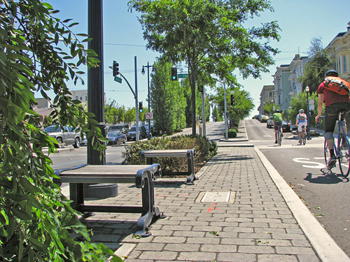 pedestrians crossing (or wanting to cross) mid-block, rather than at intersections. To design for that inevitability – and to support the low-speed design we need for this section of north Broadway – the design needs to include raised medians along the street. Raised medians reduce average car speeds, increase motorist attentiveness, substantially shorten pedestrian crossing distances, and promote street beautification. I therefore believe raised medians should be included in the Community Cycles recommendation.
 Charleston, etc. — cities that will NEVER go out of style). It will ALWAYS make sense for us to design for people instead of cars. The age of huge parking lots and multi-lane roads is a dinosaur age. Either we jettison that mistaken age, or we will lock ourselves into a downwardly spiraling path toward extinction.
 and successfully advocate for quality, walkable design for humans, efforts to protect non-human habitats are ultimately doomed, as growing numbers of humans flee the low quality human habitat for the promise of bliss in the undeveloped, unspoiled regions. By contrast, urbanists using the transect methodology have a tool that instructs on what must be done in all habitats — be they urban/human, suburban/sub-human, or ecosystem/non-human. The transect recognizes that one size does not fit all. Environmental scientists often (not always) act as if one size does fit all.
