By Dom Nozzi
Many American communities are places with a high quality of life; a youthful, active and well-educated population; communities rich with diversity, culture, and historical features; and within a region possessing outstanding yet fragile natural areas.
However, in many places, the quality of life is seriously threatened by a significant levels of sprawl, farmland loss, habitat destruction, air pollution, noise pollution, visual blight, neighborhood decline, and the death of town centers.
American communities deserve to be a place where seniors and children can be more independent-instead of dependent on others for a car ride. A place where people can experience a sense of place and a sense of community; where they can feel good about themselves, and their fellow citizens, and feel a sense of pride and respect for their community.
To promote a livable, sustainable future for people of the community, therefore, development should be measured against the yardstick which asks: “Does it make life more safe, convenient, affordable, equitable, sustainable and pleasant for people? Are there sufficient transportation and lifestyle choices provided? Does the development induce civic pride?” There are a number of components necessary to achieve such a design vision:
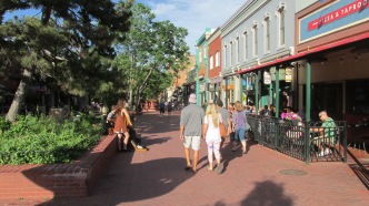
To maximize access and promote vibrant town centers, community-serving land uses in the community should be centrally located. Residential subdivisions should be discouraged in remote, auto-dependent locations—typically a distance greater than three miles from the town center core, which represents the limit of convenient bicycle and transit range. Neighborhoods should be designed at a compact, pedestrian scale—which means that jobs, parks, schools, and civic uses are within the 1/4 mile convenient walking distance of the center of the neighborhood. All new housing, businesses and community parks are within easy walking distance of a neighborhood center or neighborhood transit stop. Town centers are no larger than 1/4 mile in radius. The town center core should be restored (when necessary), pedestrianized, and revitalized to promote compactness, a sense of community and a sense of pride, as should other neighborhood commercial centers. It should be a town center of entertainment, culture, cuisine, and public life.
Land should be taxed instead of buildings/improvements. Because nearly all communities in America tax the latter, many properties sit unused, abandoned, neglected, or underused as parking. Why? Because the tax structure penalizes infill and renovation of such property. An effective solution is to tax land more heavily than buildings.
Speculators holding deadening town center parking lots are penalized. Developers who want to create new, energizing buildings and building expansions or improvements are rewarded.
On-street parking is provided in town centers to calm traffic, enhance the pedestrian environment, and promote town center businesses (by providing convenient parking and a pleasant place to stroll). More residences are established within town centers. In these centers, densities and Floor Area Ratios are high enough to make transit efficient. High-quality infill that respects neighborhood compatibility is encouraged.
The design imperative must be the pedestrian in town centers.
A Vision for Town Centers
Mixed Use. Retail, office, residential, industrial, and park uses should be seamlessly integrated to promote access, serendipity, and affordability. A mix of housing affordability should be encouraged by allowing well-designed, unobtrusive “granny flats,” carriage house apartments, and residences above offices and retail. Small grocery stores and other small shops at neighborhood street corners are encouraged. Housing integrated with non-residential uses (by being either proximate or mixed within a building) enhances security through citizen surveillance, reduces the need for motor vehicle travel, increases housing affordability, and promotes more vibrant commercial areas. Through such design, it is pleasant, safe and convenient to live in a town center without being forced to use a car. Bicycle and pedestrian links from neighborhoods to transit stops are well-designed and required of new development. Mixed use zones prohibit land uses which discourage pedestrian activity, such as car washes, gas stations, motels, storage facilities, stand-alone parking, auto dealerships, and drive-throughs.
Modest Building Setbacks. Buildings should create pleasant “outdoor rooms” by forming modest, human-scaled spacing with nearby buildings. This is achieved by setting maximum building setbacks (also known as “build-to lines”), which typically mean buildings are pulled up close to the street to ease pedestrian access and create outdoor rooms. A rule-of-thumb building-height-to-street-width ratio is 3:1. Modest building setbacks and streetwalls formed by buildings along the street will create an intimate atmosphere that people will feel comfortable to be in.
Vistas. Streets should be designed to be memorable and pleasant, which usually means the incorporation of important buildings to terminate street/corridor vistas. Important civic buildings are typically located at vistas, or in other honorable locations that are highly visible to the community so that they are afforded the respect they deserve, instead of being trivialized by being tucked into a commercial strip away from the town center core.
Modest Provision of Parking. Too often, stores, offices and cultural/entertainment facilities are designed to maximize the amount of free and convenient auto parking available. This maximizes the number of patrons from a wide area. The problem is that it creates a regionalized land use which thereby externalizes costs to the community through negative stormwater impacts, incompatibility with nearby neighborhoods, heat island effects, “gap-tooth” impacts that reduce commercial/civic vibrancy, promote noise pollution, create visual blight through promotion of a “sellscape,” and dangers due to the high vehicle volume generated. The preferred approach is a cap placed on town center parking supply (unless it is put within a multi-story garage with first floor office and retail), and market-based pricing of parking. In addition, minimum parking requirements are coupled with maximum requirements so that developers do not provide too much parking.
Interconnected Streets. Streets should be designed to connect with other streets, as was done traditionally to ease travel by pedestrians, bicycles, emergency vehicles, cars and transit. Streets that terminate through use of cul-de-sacs externalize costs to society by increasing auto dependence (cul-de-sacs significantly increase travel distances by transit, pedestrian, and bicycle). While the cul-de-sac is popular because it minimizes vehicle trips on it by people not living on the street, it promotes more trips by car for those living on the street, which increases noise and air pollution, and safety problems for other neighborhoods. An interconnected grid pattern is most efficient and convenient for all forms of travel, and is well-ventilated enough so that there is “real time” trip route choice (particularly needed if there is an emergency trip and a route is congested). In addition, a connected network minimizes congestion by distributing trips on streets so that not all trips are forced onto one or a few major roads. Gridded streets are also more memorable and less confusing than the curvilinear, spaghetti and lollipop design of auto-oriented street networks.
A Sense of Community. Development design fosters an attractive public realm promoting face-to-face interaction, friendly exchanges with fellow citizens (instead of angrily competing with them for space on a high-speed road), and centrally located regular gatherings such as festivals, farmers markets, concerts and rallies. Citizen participation is encouraged for decision-making by an invigorated civic life. Healthy, interactive neighborhoods allow shared day care, shared labor, shared tools, and shared surveillance.
Respect for Local History. It is important for a community to retain historical structures from the past, partly because such structures were often designed for the pedestrian–which inherently promotes livability. In addition, they often embody quality aesthetics since more dignity, respect, attention to detail (visible to the pedestrian but forgotten today, in which the speed of travel on our major roads, and building setbacks, are too high to care about or notice detail) and a desire for long-term durability were typically incorporated into historic structures. Also, historic structures serve to remind us of where we were in the past and what was important to us, which informs us about how we got where we are today. This includes renovation and restoration of cherished buildings and neighborhoods of the past-respecting the historic design in the process.
Context-Sensitive Design. The region and its towns use a “transect-based” regulatory system that includes land development codes acknowledging that one size does not fit all. That the full range of lifestyles are provided for in communities. Not just the suburban, car-oriented lifestyle, but also the walkable urban lifestyle and the rural, pastoral lifestyle. Suburban design should be one of many lifestyle choices, not the only choice. That is, creating urban, suburban and rural zones in each community, and applying variable, appropriate regulations for each zone that are designed to maximize the quality of each zone for that lifestyle. Transect-based regulations help unify “overlay” plans, which have proliferated in recent decades as a way to try to customize regulations for special places in the community. This proliferation often results in an enormous number of overlays throughout the community, which becomes confusing, contradictory and difficult for administrative staff and developers. There are rural, suburban and urban road design specifications.
Proper Scale and Local Ownership. Except in the case of prominent civic land uses, properly scaled design means that the design is based more to serve a neighborhood than a region. This promotes access, a seamless connection to the residential areas served, minimized noise and sign pollution, less visual garishness, and structural compatibility with nearby structures. By requiring proper scale, we protect and promote smaller, locally-owned businesses which are better at keeping money circulating in the local economy. We also discourage “big boxes,” which are typically out of scale, not locally owned, predatory on locally-owned small businesses, promote auto dependence, and exhibit other relatively high levels of externalized costs. In addition, in pedestrian-oriented areas, drive-throughs are prohibited, since they are hostile to pedestrians, promote auto dependence, harm small local businesses, remove pedestrians from the sidewalk (pedestrians are the lifeblood of a vibrant town center) and cater to citizens living in remote locations. Another way to describe proper scale is “human” scale.
Street Design. To promote sustainability, access, serendipity, and livability, town center streets should be designed to promote moderate motor vehicle speeds (by using traffic calming techniques), and use by all forms of travel (pedestrian, bicycle, transit, car, handicapped, senior citizen, child, etc.). Travel lanes wider than 11 feet are phased out. Lanes from 8 to 10 feet are preferred. Local street turning radii are no more than 15 feet. Streets serve multiple purposes, and are never more than 3 lanes in size. In addition to car travel, they are safe and pleasant for bicycling, socializing, business transactions and recreation for children, as they had been so used in the past. Streets designed to accommodate high auto volumes and speeds inevitably create a strip commercial “sellscape,” especially when the street reaches the 40,000 ADT and 40 MPH threshold (the “40/40”). In addition, when street capacity is increased by adding travel lanes or turn lanes, traffic volumes and suburban sprawl inevitably increase due to the phenomenon of the “triple convergence,” “travel time budgets,” and the fact that road modifications that make life easier for cars is a “zero-sum” game which inevitably makes life less feasible for all other forms of travel (pedestrian, bicycle, transit, etc.). Street blocks should be no longer than 500 feet in length. Subdivisions are designed with alleys. Gateway streets announce that a person has arrived in a “town center within a forest.” Parking lots are prohibited from fronting a street to avoid “gap tooth” areas hostile and unpleasant for the pedestrian. Instead, they are on the side or rear of the building. Houses incorporate front porches, sidewalks on both sides of the street, and picket fences. The house has a modest front yard setback so that porches are within “conversation distance” of the sidewalk. Commercial, residential, and civic buildings face the street and are pulled up to the street to form street walls and outdoor rooms. Building walls facing sidewalks have windows to provide pedestrians with visual interest. Main Street and University Avenue in the Gainesville downtown core are reduced to three lanes to slow traffic, improve retail health, promote residential and office development along the corridor, increase use by bicycles and pedestrians, provide on-street parking, and enhance aesthetics of these key corridors.
Aesthetics. Strong sign and lighting controls work to retain a calm, soft, gentle, “small town” and friendly atmosphere. Overhead utility infrastructure is incrementally placed underground or otherwise hidden from view to reduce visual impact. Roadways are well landscaped, as are gateways, medians, and parks. Graffiti is cleaned up and guarded against, as is litter and dumping.
Character of Buildings. Buildings are designed to be compatible with the region’s historic architectural vernacular.
Recycling and Energy Conservation. Economic, regulatory and convenience incentives are used to promote aggressive recycling and reuse (particularly reuse of buildings). Incentives are established to reduce local energy consumption, thereby protecting groundwater, surface water, and air quality, as well as reducing our local vulnerability to oil volatility and increasing self-sufficiency.
Greenways. Our overemphasis on designing for cars has given us communities featuring low densities, streets that are not interconnected, dangerous roadways, and long distances between trip origins and destinations. Greenways allow us to “retrofit” our suburbs by creating safe, pleasant, and convenient pedestrian and bicycle connections from neighborhoods to trip destinations such as jobs, parks and shopping, which reduces auto dependence. They recruit new bicyclists and pedestrians. They also reduce crime by increasing citizen surveillance, increase equity by creating a low-cost alternative to expensive car travel, and promote environmental conservation by promoting public land acquisition along wildlife corridors and increasing citizen awareness and appreciation for our ecosystems. To the extent possible, greenways and other corridors are used to reconnect significant natural areas fragmented by sprawl and roads. The community works to minimize the adverse impacts of urban and other human discharges (particularly stormwater and exotic vegetation) to such areas. Significant natural areas, when necessary, are restored and buffered.
Economic Health. Livability, environmental conservation, and quality of life strategies are used as engines to promote long-term retention, expansion, and recruitment of environmentally benign employers. Eco-tourism is nurtured and developed so that a vested economic interest in protecting the natural environment is created.
Community Definition and Farmland Preservation. Town centers have well-defined edges that clearly show a transition from urban to rural farmland, instead of urban strip commercial and residential dribbling out into rural areas around the town center. Farmland is protected and preserved from urban encroachment by urban growth boundaries, thereby ensuring a local supply of farm-fresh produce and enhancing local self-sufficiency and sustainability.
Equity. People living in central areas of towns and cities should not see their taxes increase in order to subsidize costly sprawl development. Instead, regulations should prevent such development. Sprawl development that has not been prevented should pay its own way. By designing for people and livability rather than cars in the manner described above, we make cars less necessary for life in town centers. This means an increase in equity along the continuum of economic classes, since car ownership is so costly for households. In a car-designed community, we find that we are closing off opportunities for those households that are less wealthy.
Serenity. A crucial way to promote quality of life—particularly in town centers—is effective noise control. Noise pollution is growing exponentially in most communities, and results in a great many people deciding not to live within town centers. Screaming emergency vehicle sirens, shrieking burglar alarms, whining parking lot vacuum trucks, police helicopters, and highly annoying leaf blowers are destroying the quiet ambience that citizens have the right to enjoy and expect. The rise in incivility, in part, translates into an inability to understand the fundamental principle of civilization: Your right to swing your fist ends at the beginning of your neighbor’s nose. People have the right to be free from the pollution of others. Nothing prevents a community from significantly reducing its noise problems except political will.
A livable, sustainable community is a vision we can realize with proper community design. Such design can serve as a powerful economic engine that brings jobs to the region. And it can reduce the polarization that the county has seen between developers, and the neighborhoods and environmentalists who oppose them. Instead, we can build bridges between such groups, and at the same time create a high quality of life and a sustainable, equitable community.
_________________________________________________
Visit my urban design website read more about what I have to say on those topics. You can also schedule me to give a speech in your community about transportation and congestion, land use development and sprawl, and improving quality of life.
Visit: www.walkablestreets.wordpress.com
Or email me at: dom[AT]walkablestreets.com
 My memoir can be purchased here: Paperback = http://goo.gl/9S2Uab Hardcover = http://goo.gl/S5ldyF
My book, The Car is the Enemy of the City (WalkableStreets, 2010), can be purchased here: http://www.lulu.com/product/paperback/the-car-is-the-enemy-of-the-city/10905607
My book, Road to Ruin, can be purchased here:
http://www.amazon.com/Road-Ruin-Introduction-Sprawl-Cure/dp/0275981290
My Adventures blog
http://domnozziadventures.wordpress.com/
Run for Your Life! Dom’s Dangerous Opinions blog
http://domdangerous.wordpress.com/
My Town & Transportation Planning website
http://walkablestreets.wordpress.com/
My Plan B blog
https://domz60.wordpress.com/
My Facebook profile
http://www.facebook.com/dom.nozzi
My YouTube video library
http://www.youtube.com/user/dnozzi
My Picasa Photo library
https://picasaweb.google.com/105049746337657914534
My Author spotlight
http://www.lulu.com/spotlight/domatwalkablestreetsdotcom


 Human-scaled streets create the overwhelmingly pleasant feeling of being within an “outdoor room.” And, as a result, creating that all-important “sense of place.”
 civic pride is cultivated, and those within the community are sent a strong message about what the community believes are the most significant institutions in the community. Vista termination also creates the impression that the walk does not seem onerously “endless,” as a goal is in sight in front of the pedestrian. As Andres Duany has said, nothing is more satisfying than a prominent civic building grandly terminating a street vista.


 when a car is mandatory. Indeed, approximately one-third of all Americans are unable to drive a car.
 a community to attract and retain Richard Florida’s “Creative Class”, the young, smart citizens that communities depend on for a health economy and healthy overall community. “Brain Drain” is most likely to occur in placeless cities which lack the character, vibrancy, “hip-ness” and attractiveness provided inherently by a walkable community.
 believe are clear, accurate criteria that describe the essential elements of walkable urbanity. They list four characteristics, which they point out should be present, to some extent, in all places that wish to be considered “urban.” Besides the obvious “walkability” criterion, they list
 building far back from the street or intersection, all semblance of human scale (not to mention walkable distance) is lost.
 out the walkability of various locations is to use the

 from bicycling at all. Each time a street is traffic-calmed, or has travel lanes removed (road dieting), bicycling is dramatically improved and there is a significant increase in bicycling. A large percentage of streets carry car traffic that features uncomfortably and dangerously high speeds, and a number of streets can greatly benefit from travel lane removal (for example, 5- or 4-lanes to 3). Many of these diet opportunities provide a way to install an in-street bicycle lane on streets that do not have space today, and in-street bicycle lanes are, by far, preferable to off-street paths for commuter bicycle travel. Because 4-, 5-, and 6-lane streets are a primary cause of high speed car traffic and inattentive, reckless driving, it is important for a community to avoid building them, and to “diet” those that are already at that size. High-speed, inattentive driving significantly discourages bicycling in most every community.
 lanes are not appropriate on low-speed downtown streets or neighborhood streets. Their application tends to be most appropriate on higher-speed suburban arterial streets.


 A downtown that is exciting, human-scaled, walkable, and filled with activities is a downtown that most people will figure out a way to get to, regardless of the “lack” of free parking. Major attractions draw enormous numbers of people, even though the available parking is “insufficient.”
 terms. Suburbs will always be able to provide more parking and wider highways more cheaply. Downtown can only compete where it can have competitive leverage. That is, by being compact, walkable, romantic, unique, rich in history and human-scaled.


