Tag Archives: neighborhood

Drunk Driving and Car-Dependent Suburbs

By Dom Nozzi

Drunk driving is far more prevalent today than it was in the past, and it is not because people drink more today than in the past, or that drunk driving was more harshly punished in the past. The increase in drunk driving is largely caused by our creating a society where driving everywhere is mandatory.

For example, neighborhood-based Third Places (such as pubs) have been removed from residential neighborhoods by making it illegal to locate them there. When Third Places were removed from neighborhoods, drinking did not stop. What DID stop was drinking then walking home. Now, a very large number of people are obligated to drink and then DRIVE home. This is one of countless reasons why a car-dependent society is unsustainably costly and has no future.

Ray Oldenburg describes this very well in his The Great Good Place.

By the way, one obvious tactic for sanctioning drunk drivers is to take away their drivers license. But this law is very difficult to adopt, and again, our car-based society is to blame. After all, in a society where every single trip must be made by car, a law that takes away a drivers license makes it nearly impossible for a person to survive in his or her world. That means that a lot of people — particularly those in positions of power — will fight very hard against adoption of such a law.

In sum, the long-term strategy to significantly reduce drunk driving is not harsh laws or long jail terms. It is returning to the timeless tradition of designing walkable communities — in part by making it legal to once again allow the establishment of shops and pubs and groceries and offices in neighborhoods.

I hope to see the day when we end our brief, ruinous, incredibly costly experiment of building car-happy suburbs.

Leave a comment

Filed under Politics, Sprawl, Suburbia, Transportation, Walking

The Big Box Church


By Dom Nozzi

December 11, 2003

As I write this, the current controversy in Gainesville FL is that the local community college downtown is trying to demolish two historic homes in a walkable, historic neighborhood abutting them. I’ve not heard this, but will be surprised if the college doesn’t end up putting in surface parking once they obliterate the houses. It is causing quite an outcry from the neighborhood and from the historic folks.

The University of Florida (and the Shands/Alachua General Hospital complex east of the university) has done their part to undermine nearby neighborhoods. Much of Shands/AGH is now surface parking. Quite a large number of historic homes were leveled to put in those seas of asphalt.

These days, one of the most common issue we city planners see raised in our planning newsletters and magazines is the emergence of the “Big Box Church” (the godly version of Big Box retailers such as Wal-Mart). There have been a lot of articles published in the church-campus4professional planning literature about churches growing enormously in size. To be healthy is to have lots of parishioners, which means that many churches now strive to serve a huge region. That, of course, means huge parking lots are imperative. Combined with recent US Supreme Court rulings and congressional action which severely restricts local governments from regulating churches (due to alleged “freedom of religion” intrusions), most communities (including Gainesville) are terrified of imposing even the most trivial land development regulations on churches. There is now much less planners can do anything to protect neighborhoods by restricting how much parking a church can have, or imposing noise limits on them, or even imposing special landscaping or building location or zoning rules. Homes near these new mega-churches now have little or no protection against loud churches or parishioners speeding through the neighborhoods or parking in people’s front yards.

There has been much talk about the downtown Episcopal Church here in Gainesville having problems and thinking about re-locating to Sprawlsville.

Why?

Not enough parking for the parishioners.

I’m sure they pray about leveling City Hall to install a new parking lot…

In the past (decades ago?), churches and hospitals and small schools were healthy and walkable for neighborhoods. In fact, like public grade schools, I’d argue that human-scaled, walkable, neighborhood-based colleges, hospitals and churches are essential ingredients in a healthy neighborhood. But the fact that we now must assume that everyone will drive everywhere means that such places MUST level buildings in order to install more and more surface parking.

Tragic.

Leave a comment

Filed under Transportation, Urban Design

Should Neighborhoods Be Given the Right to Vote on Land Use Changes?

By Dom Nozzi

In the fall 2015 elections, Boulder citizens will be voting on Ballot Issue 300, “Neighborhoods’ Right to Vote on Land Use Regulation Changes.” It is a form of direct democracy. Many citizens in Boulder have lost confidence in the ability of their elected representatives to “listen” to neighborhoods and vote accordingly.

But there are reasons our society is a representative democracy rather than a direct democracy. Direct democracy does not work – particularly in a complex society such as ours. If it did, we would simply need computers to measure public opinion on community issues rather than electing representatives.

Direct democracy is a form of “mob rule.” Emotions and lack of knowledge will mean that citizens will regularly vote against their own best interests.saintreportpicture3

Had direct democracy been used in Boulder in the 1970s for the conversion of Pearl Street Mall into what has become a much loved pedestrian mall, it would have never been approved, as it would have lost badly in a direct vote. There would be no Boulderado hotel – perhaps the most loved building in Boulder today, no Holiday neighborhood – an excellent and admired example of a walkable mixed-use neighborhood, much less residential and office development in downtown Boulder, and no Mapleton neighborhood – a charming and attractive Victorian neighborhood that is so cherished by so many that its homes are exceptionally expensive.

There are many additional reasons why direct voting as proposed by Measure 300 is a bad idea.

For example, the town planning profession is trivialized by suggesting that no advanced knowledge is necessary to make intelligent decisions about community development.

If direct voting is a good idea, why are we not, say, having a neighborhood vote on whether a community tax increase should apply to the neighborhood?

Is Boulder comfortable with its taxes being increased substantially to pay for such a large increase in community voting and added time needed by staff to prepare such votes?

Renters will not be allowed to vote.

In a society such as ours where there are enormous, counterproductive subsidies in place that distort the “signals” we citizens get, it is inevitable that many votes will be counter to neighborhood and community interests. For example, very high subsidies for car travel (free parking and underpriced gas) lead many to be artificially over-wedded to car travel.

“Right to Vote” will give even more advantages to more wealthy, large developers who are powerful enough to mount successful campaigns to prevail in a neighborhood vote (compared to smaller, less wealthy, local developers). Similarly, more wealthy neighborhoods will be advantaged over less wealthy neighborhoods for similar reasons.

Measure 300 really does nothing, when it comes right down to it, to protect or promote quality of life. It turns out that it is a “no growth” effort masquerading as a community benefit.

1 Comment

Filed under Politics

Traditional, Sustainable, Affordable Urban Design

By Dom Nozzi

When I was a town and transportation planner in Florida, I sought to incorporate the following traditional neighborhood development principles into the long-range land use and urban design plans for my community. I was not allowed to do so, but I hope that planners elsewhere will be able to incorporate some or all of this in the plans of their communities…

Cities throughout the country face many of the same problems — increasing traffic problems, worsening air and noise pollution, the loss of outlying farms and open spaces to suburban sprawl, the growing need for costly road widenings and the provision of expensive urban services to such remote development, increasing visual blight, traffic injuries and deaths, wildlife habitat loss, the decline of downtowns, loss of independence for children and seniors who cannot drive, loss of civic pride, a growing household financial crisis, a loss of serendipity, and a loss of a sense of place and community.

City character becomes blurred until every place becomes like every other place — all adding up to no place.

Our streets become increasingly congested and our destinations further and further away. We increasingly spend our time as anonymous individuals waiting at the traffic light instead of socializing with friends at the corner store or playing with the kids at the park.

All the places where people could meet in public and experience a sense of community — the square, the corner pub, the main street — have been replaced by oceans of asphalt for the movement and storage of space-hungry cars.

There were neighborhood design principles that characterized development in the U.S. before WWII. The following principles exemplify these conventions:

* Neighborhoods are limited in size and oriented toward pedestrian activity.

In general, “limited in size” means that most every form of daily household need is within a five-minute walking radius (approximately one-quarter mile);

* Residences, shops, workplaces, and civic buildings are interwoven within the neighborhood and in close proximity, which creates a vibrant, livable neighborhood featuring transportation choice. This mixed use is primarily achieved by calling for compatibility of scale and intensity;

* Streets are interconnected and the blocks are small. This street pattern, in combination with other design features of the traditional neighborhood development, strikes a balance between the needs of the car, the bus rider, the pedestrian and the bicyclist;

* Civic buildings are given prominent, high-visibility locations that thereby act as landmarks, symbols and focal points for community identity. These buildings are therefore assigned the proper level of community priority and serve as places of assembly for the neighborhood;

* There is a distinct edge, or transition, between the developed area and outlying farmland and greenbelts;

* Public spaces create a pleasant, safe public realm and are formed and defined by the proper alignment of buildings;

* A full range of housing types is provided, which allows all age groups and income classes to be integrated.

A traditional neighborhood also features the following benefits:

* Gives people without access to a car, such as children, the elderly, and the disabled, more safety and independence in their world.

* Substantially reduces government and household costs — especially because of the enormous savings in the building and maintaining of road infrastructure, and the purchase and maintenance of cars.

* Features streets designed to slow traffic. It increases travel choices and reduces the length and number of vehicle trips. This, in addition to providing proximity by mixing land uses, allows the traditional neighborhood development to achieve a relatively high “trip capture rate,” which vastly reduces the significant transportation impacts the neighborhood displaces to the larger community.

* Contains structures built for permanence, instead of structures designed, as too many contemporary structures are, for a short-term “throw-away” life.

* Makes walking feel more enjoyable.

* Minimizes strip commercial visual blight.

* Increases citizen access to culture.

* Creates a good environment for smaller, locally-owned businesses to become established and to operate in.

* Creates a sense of place, a sense of community, a sense of belonging and restores civic pride and place-based loyalty.

* Increases transit viability, primarily through density, access, traffic calming, community-serving facilities, compactness, mixed use and pedestrian amenities.

For these reasons, City land development policies and land use categories should be revised to make such traditional, “timeless” development more feasible – particularly because such development is highly desirable for the reasons described above, yet there is little or no choice to live in such developments. Important ways to incentivize such traditional developments:

* Adopt a traditional neighborhood development (TND) ordinance.

* Revise land use categories to make TNDs allowed by right.

* Establish town center design guidelines that will transform centers into walkable, transit-oriented developments (TODs). See the Transportation Element for a description of TOD elements.

* Reduce fees, and the review and approval process, for TNDs and TODs.

The Ahwahnee Principles (adopted in the long-range plans of several communities around the U.S.)

Preamble

Existing patterns of urban and suburban development seriously impair our quality of life. The symptoms are: more congestion and air pollution resulting from our increased dependence on cars, the loss of precious open space, the need for costly improvements to streets and public services, the Haile Village9inequitable distribution of economic resources, and the loss of a sense of community. By drawing upon the best from the past and present, we can, first, infill existing communities and, second, plan new communities that will more successfully serve the needs of those who live and work within them. Such planning should adhere to these fundamental principles:

Community Principles

  1. All planning should be in the form of complete and integrated communities containing housing, shops, work places, schools, parks and civic facilities essential to the daily life of the residents.
  2. Community size should be designed so that housing, jobs, daily needs and other activities are within easy walking distance of each other.
  3. As many activities as possible should be located within easy walking distance of each other.
  4. A community should contain a diversity of housing types to enable citizens from a wide range of economic levels and age groups to live within its boundaries.
  5. Businesses within the community should provide a range of job types for the community’s residents.
  6. The location and character of the community should be consistent with a larger transit network.
  7. The community should have a center focus that combines commercial, civic, cultural and recreational uses.
  8. The community should contain an ample supply of specialized open space in the form of squares, greens and parks whose frequent use is encouraged through placement and design.
  9. Public spaces should be designed to encourage the attention and presence of people at all hours of the day and night.
  10. Each community or cluster of communities should have a well-defined edge, such as agricultural greenbelts or wildlife corridors, permanently protected from development.
  11. Streets, pedestrian paths and bike paths should contribute to a system of fully-connected and interesting routes to all destinations. Their design should encourage pedestrian and bicycle use by being small and spatially defined by buildings, trees and lighting; and by discouraging high speed traffic.
  12. Wherever possible, the natural terrain, drainage, and vegetation of the community should be preserved with superior examples contained within parks or greenbelts.
  13. The community design should help conserve resources and minimize waste.
  14. Communities should provide for the efficient use of water through the use of natural drainage, drought-tolerant landscaping and recycling.
  15. The street orientation, the placement of buildings and the use of shading should contribute to the energy efficiency of the community.

Regional Principles

  1. The regional land use planning structure should be integrated within a larger transportation network built around transit rather than highways.
  2. Regions should be bounded by and provide a continuous system of greenbelt/wildlife corridors to be determined by natural conditions.
  3. Regional institutions and services (government, stadiums, museums, etc.) should be located in the urban core.
  4. Materials and methods of construction should be specific to the region, exhibiting continuity of history and culture and compatibility with the climate to encourage the development of local character and community identity.

Approve proposed accessory dwelling units, such as “granny flats”, carriage houses, garage apartments, and add-ons to a detached single-family residence. When done properly, this allows the city to retrofit higher, more livable densities without harming neighborhoods. Encourage or require a mix of housing types.

Strategies:

* The City will promote a mix of land uses and activities that will maximize the potential for pedestrian mobility throughout the city.

* Buildings should be sited in ways to make their entries or intended uses clear to and convenient for pedestrians.

* The location and pattern of streets, buildings and open spaces must facilitate direct pedestrian access. Commercial buildings should provide direct access from street corners to improve access to bus stop facilities.

* Creating barriers which separate commercial developments from residential areas and transit should be avoided.

* Direct sidewalk access should be provided between cul-de-sacs and nearby transit facilities.

* Traffic calming should be further developed on city streets to enhance the safety of street crossings. Curb radii should be minimized to reduce the speed of right-turning vehicles and reduce the distance for the pedestrian to cross the street. Calming should be used to discourage speeding and cut-through traffic. Street widths should be as narrow as possible.

* The City will encourage the provision of pedestrian scale improvements that fit the context of the area. The color, materials, and form of pedestrian facilities and features should be appropriate to their surroundings, as well as the functional unity of the pedestrian network.

* The City will encourage housing development near major employment centers to foster travel to work by all forms of transportation.

* The City will encourage a variety of housing types and densities, including mixed use developments, that are well-served by public transportation and close to employment centers, services and amenities. In particular, the City will promote the siting of higher density housing near public transportation, shopping, and in designated neighborhoods and districts.

* The City will recognize accessory housing units as a viable form of additional — and possibly affordable — housing, and will develop special permit procedures, criteria, and restrictions governing their existence that are designed to facilitate their development while protecting existing residential neighborhood character.

* Neighborhood streets and sidewalks will form an interconnected network, including auto, bicycle, pedestrian, and transit routes within a neighborhood and between neighborhoods — knitting neighborhoods together and not forming barriers between them. Dead ends and cul-de-sacs should be avoided or minimized. Multiple streets and sidewalks will connect into and out of a neighborhood.

* To keep all parts of the community accessible by all citizens, gated street entryways into residential developments will not be allowed.

* On long neighborhood blocks, intermediate connections in the pedestrian network should be provided, with a maximum distance of about 500 to 700 feet between walking connections. In particular, direct walkway and bikeway routes to schools should be provided.

* All multiple-family buildings should be designed to reflect, to the extent possible, the characteristics and amenities typically associated with single-family detached houses. These characteristics and amenities include orientation of the front door to a neighborhood sidewalk and street, individual identity, private outdoor space, privacy and security.

* Home occupations should be allowed in all residential areas provided they do not generate excessive traffic and parking, or have signage that is inconsistent with the residential character of the neighborhood.

* To foster visual interest along a neighborhood street, the street frontage devoted to protruding garage doors and driveway curb crossings will be limited. Generally, garages should be recessed, or if feasible, tucked into side or rear yards, using variety and creativity to avoid a streetscape dominated by the repetition of garage doors.

* If possible, the view down a street should be designed to terminate in a visually interesting feature.

Converting Conventional Shopping Centers into Walkable Urban Villages

Conventional shopping centers containing only retail, office and service uses, tend to be designed only for the car. Asphalt parking lots tend to be enormous, and push buildings a tremendous distance from the street. This form of “auto architecture” significantly reduces transportation choice, makes access difficult for those without a car, create urban “heat islands” and stormwater problems, and eliminate the possibility of buildings defining a pleasant, human-scaled public realm. The atmosphere tends to be unpleasant. There is no sense of place, sense of community, unique character or sense of civic pride.

Increasingly, however, such shopping centers are being rebuilt to form a pleasant, walkable urban village. Shops, offices, and residences face each other in a compact atmosphere reminiscent of traditional main streets.

Because they promote transportation choice, they equitably allow access and enhance environmental conditions. And they provide a superior quality of life and ambiance that allows them to profitably compete with more conventional centers.

Clustering higher density housing near the walkable urban villages can substantially increase transit use.

Features of a Walkable Urban Village:

* A gridded street network lined with street-facing buildings, and interspersed with squares and plazas.

* A comprehensive sidewalk and street tree network.

* Compact, vertically and horizontally mixed land uses including residences, retail, office, service, and civic activities.

* A “Park Once” environment.

* A strong connection to transit service.

* Bounded by relatively high residential densities.

* A vibrant public realm created by healthy pedestrian volumes, street vendors and performers, a broad mix of uses, and 24-hour activity.

The City should adopt land development regulations that lead to the transformation of conventional shopping centers to walkable urban villages.

Causes of sprawl:

* Widening major roads with travel lanes and turn lanes;

* Free and abundant parking for cars;

* Lack of quality public facilities in core areas, such as schools, parks, and trails;

* Poor codes enforcement in core areas, which leads to excessive noise pollution, car parking problems, unsightly signage, and unkempt homes;

* Poor public schools in the city center, and construction of public schools and community-serving facilities in areas remote from the city center;

* Land development codes which excessively promote the convenience of the car instead of transportation choice;

* Water and sewer extension policies;

* Low-cost gasoline;

* Poor quality transit service;

* Low overall quality of life in the city;

* Flight from crime, poverty, and “auto architecture”;

* For non-residential uses, more convenient access for cars throughout the region due to abundant space for parking, lower costs for building construction, lower land values, and easier access to Interstate highways;

Negative effects of sprawl:

* Increased city costs for infrastructure and services;

* Increased per capita trips by car;

* Increased travel times;

* Increased household expenditures for transportation;

* Reduced transit cost-effectiveness and frequency;

* Increased social costs (increased air, water, noise pollution);

* Loss of farmland;

* Reduced farmland productivity and viability;

* Loss of sensitive natural areas and wildlife habitat, or fragmentation of  such areas;

* Loss of regional, community-separating greenbelts and open spaces;

* Increased urban ugliness due to “auto architecture”;

* Weakened sense of community, sense of place, and sense of civic pride;

* Increased stress;

* Increased energy consumption;

* Reduced historic preservation;

* Segregation by income, age group, and race;

* Separates low-skill, high unemployment areas from new jobs;

* Increased fiscal stress for the city;

* Increased rate of inner city decline;

Returning to these design principles is a recipe for a more sustainable, affordable future rich in lifestyle and transportation choice, equity and quality of life.

1 Comment

Filed under Sprawl, Suburbia, Transportation, Urban Design

Fleeing from the Public Realm

By Dom Nozzi

Over the past several decades, Americans have increasingly cocooned themselves. As the fear of crime (and “strangers”) remains high, many spend more time than their parents and grandparents inside the private realm of their homes – homes that are increasingly becoming walled, fortified, burglar-alarmed fortresses on cul-de-sacs. Many have fled from the more communal, compact town center neighborhoods to dispersed, low-density sprawl neighborhoods. Some of us live within “gated” communities where a guard grants permission to visitors wanting to enter the “compound” of a walled-in neighborhood.Phoenix-Gated-Community

The move toward the private realm is a form of escape from public life. I believe the desire to escape is driven, at least in part, by the increasing misery, barren-ness, and danger associated with the relatively awful American public realm. As the public realm becomes increasingly dreadful in these ways, we have almost completely lost any sense of community, or the common good, or any form of civic pride. Of course, some might point to the jingoistic pride that is often exhibited (flag waving, “USA!!”chants, etc.), but I think that most of that sort of national “pride” is largely associated with the fact that our cheap energy economy is able to deliver a cornucopia of consumer goods (and political freedom, which has lost its meaning because there is no one worthy of our vote) to even those in the lower classes.

2012-garage-full-of-yard-saleIndeed, many, many people, in my opinion, mistake the ability to buy a bunch of consumer goods with political liberty, freedom, and quality of life. The end of cheap energy, I believe, will lead to big increases in political turmoil fueled by economic resentment and economic misery. Scarcity and the high costs associated with that will, I hope, compel us to be more interested in and drawn to community and the public realm, and less focused on an “all about me” attitude.

As a side note, I was horrified a number of years back to see a quote from a University of Florida student in the College Park neighborhood in Gainesville, Florida. The student was being cited by City Codes Enforcement for his unkempt, littered yard. He told the officer that he had a right to have his yard be a mess because of the political liberty that Americans enjoy.

WHAT??

In other words, a good many people apparently (and bizarrely) equate liberty with the right to litter or otherwise behave in an uncivil manner. “Screw others!”

In my travels in Europe, by stunning contrast, I am invariably completely astonished by the magnificent, ornamental, historic civic buildings, public squares, and shops that I see nearly everywhere I go. The public realm, unlike the downwardly spiraling and increasingly neglected place of misery that so many Americans are fleeing, consists — in the older parts of European cities — of places worth caring about.

In these charming, romantic, human-scaled sections of Europe, one finds it fantastically rewarding to walk the livable, human-scaled streets — many of which were bustling places filled with pedestrians and busy shops and outdoor cafes.

The vitality is contagious. And powerfully rewarding, because the human species is naturally sociable, yet as an American I so rarely can experience it in public – in American cities and suburbs. Nearly everyone on the European streets seem to be friendly and happy and sociable. It is so very exciting to me to see the enormous number of people walking and bicycling on very narrow, cozy streets. Traveling without a car is clearly and dramatically more humanizing for the Europeans.

In a car, even the most mild-mannered, friendly person is often compelled to get angry at “slow-pokes”, or to fume about pedestrians and other cars in the way, or how long it takes for the signal light to change. Blood pressure rises. Fellow citizens become enemies in a competition for road space. The ability to offer a friendly “hello” to your fellow citizen is lost inside a car, as is any real sense of SERENDIPITY, which is so important to a rewarding journey.

Inside a car, one usually feels as if he or she is always in a hurry.

Only as a pedestrian or bicyclist does one experience the unhurried pleasure of taking your time to smell the flowers and enjoy the morning sun. To stop to chat with an old friend you run into. To pop into a store because of something that caught your eye.

So the rich, rewarding experiences I so often joyously find in Europe are due to these human-scaled, slow-speed, pedestrian-oriented, activated streets I see there so regularly. Streets full of happy, sociable people, busy shops and cafes, and proud buildings lavishly ornamented.vibrancy stroget st

In America, most of what we experience is what Jim Kunstler calls an “auto slum.” Who wants to go for a walk in a place full of angry, high-speed motorists on 8-lane arterial roads, vast and empty asphalt parking lots?

The wretched, all-too-common experience of a strip corridor littered with auto repair shops and car dealerships, and buildings that are so far from the road that a person on the sidewalk would need a telescope to see into store windows? Assuming there even ARE windows, since growing numbers of buildings now turn their back to the street.

The natural, expected reaction for almost any sane person is to RUN FOR YOUR LIFE from such a place and safely cocoon yourself into your own little private realm, where you can endlessly, pathetically strive to be happy by buying flat-screen TVs, iPods, and luxurious furniture as a surrogate for living in a rewarding community. But how satisfying is it, in the end, to have a stupendous living room, when you don’t even know your neighbor? When all of your “friends” are simply characters in sit-coms you watch every night on TV? When your city is little more than a tangled, dangerous mess of stressed and hostile motorists, highways, parking lots, and fast food chains?

Our consumer economy thrives because it is simply not possible to buy things as a way to be happy, yet we feel compelled to buy, buy, buy in our endless, hopeless pursuit of happiness. There is, after all, no alternative, since we have no community or quality public realm to satisfy our gregarious human desires. Advertising constantly tells us that we will feel so much joy if we buy their product. But we learn that buying and owning the latest gadget is, ultimately, an empty, sterile way to live and enjoy life.

I’ve heard more than once that the Europeans are destined to a future quality of life that nearly everyone throughout the world will see as higher that the quality of life experienced in America. A recent book is titled “The European Dream” (an illuminating play on the “American Dream” we have grown up with).

I am convinced that this transition to looking at older Europe as the new dream is certain, because the European public realm is very high in quality (light years better than the miserable public realm in most all of America), and a quality public realm is the fountainhead to a high quality of life for the entire community. Quality of life is NOT found by buying the latest plasma TV set or SUV.


Leave a comment

Filed under Sprawl, Suburbia, Urban Design, Walking

A Fuel-Efficient Car is Less Important Than Where One Lives

By Dom Nozzi

James Howard Kunstler has made the point that we should “not give a fuck” whether a person drives an SUV or a Toyota subcompact. That over reliance on either worsens everyone’s life. That lifestyle decisions matter far more. That technology, as conservatives like to claim, won’t save us.big-car-and-small-car-parked-photo246

Is Kunstler right?

Let’s consider two households:

Household/Lifestyle A lives in a historic, town center neighborhood and works at a job about a mile from the neighborhood.

Household/Lifestyle B lives in a remote suburb and works at a job several miles away.

Household B commutes about 10 miles per day and drives 8 miles per day for errands. Household A commutes about 2 miles per day and drives about 2 miles per day for errands.

Gas consumption implications:

1. Let’s be generous and assume that Household B owns a super gas miser that gets 30 mpg in city driving.

2. Let’s look at worst case scenario and assume that Household A owns a gas-guzzling SUV that only gets 10 mpg.

Obviously, the disparity on the mpg difference between households would almost never be as large as in my hypothetical. I’m just using worst case scenario.

The result of the above assumptions, which I believe are, in anything, biased toward Household B:

Household A car travel per year = 1,460 miles=146 gallons of gas consumed.

Household B car travel per year = 6,570 miles= 219 gallons of gas consumed.

Even if you believe my assumptions are unfair for Household A, Household A (with the gas hog SUV still wins. For example, even if we are overly generous and assume that Household A drives 5 miles per day, we still find that Household A consumes 36 less gallons of gas than Household B.

Note that gas consumption is only one of several impacts that a motorist has on the quality of life of the community. For our purposes, it seems safe to use it as a proxy for overall quality of life impact on the community. That is, more gas consumption equals more per capita delivery of the following suburban insults to the community: more noise pollution, more wildlife road kills, more air pollution, bigger asphalt parking lagoons, bigger and less safe and higher speed roads, bigger and more cluttered sign pollution problems, more glaring light pollution problems from places trying to attract motoring customers with their lighting, more water pollution, more soil pollution, more loss of wildlife habitat, more flooding, more injuries and deaths, more loss of independence for those who do not drive, etc.

How many people who adopt and defend the unsustainable suburban lifestyle believe, pathetically, that they are “environmentally friendly” simply by driving a Honda that gets a zillion miles per gallon? That owning such a vehicle neutralizes their contribution to the ruin of their community?

That it forgives them of the subsidized sin of living in Sprawlsville?

That they can ease their guilty conscience?

In sum, it would appear that lifestyle and location decisions (and the ecological footprint such a decision creates) are far more important than the car a person decides to buy and drive.


1 Comment

Filed under Bicycling, Energy, Sprawl, Suburbia, Urban Design

Transportation is Destiny: Design for Happy People, Not Happy Cars

by Dom Nozzi

The following is a summary of a talk I was invited to give at a PLAN-Boulder County forum on Friday, January 24. As a town and transportation planner, I cautioned Boulder not to put too much emphasis on easing car traffic flows—particularly by such conventional methods as adding a second turn lane at intersections or requiring a developer to provide too much car parking. I described the ingredients of a healthy, vibrant city, summarized how a seemingly beneficial city objective of reducing traffic congestion can often undermine important Boulder objectives, and offered a number of strategies that would help Boulder both properly manage transportation and promote its long-range goals.

A great city is compact, human scaled, has a slow speed center, and promotes gatherings of citizens that catalyze “synergistic interaction” (brilliant ideas and innovations, as the sum becomes greater than its parts). Most importantly, a quality city does exceptionally well in promoting “exchanges” of goods, services, and ideas, which is the most important role of a city, and is best promoted by the interaction that occurs through compact community design.

About 100 years ago, automakers, home builders, and oil companies (“the Sprawl Lobby”) started realizing that they could make lots of money by creating what has since become a self-perpetuating vicious cycle in communities. If communities could be convinced to ease the flow of car traffic by building enormous highways and parking lots (and subsidizing car travel by having everyone—not just motorists—pay for such roads, parking, and gasoline), huge amounts of money could be made selling cars, homes and gasoline. The process eventually was feeding on itself in a growing, self-perpetuating way, because the highways, parking and subsidies were forcing and otherwise encouraging a growing number of Americans to buy more and more cars, use more and more gasoline, and buy sprawling homes that were further and further from the town center. Why? Because the subsidized highways and gasoline were powerfully promoting community dispersal, high speeds, isolation, and an insatiable demand for larger highways and parking lots. Each of these factors were toxic to a city, led to government and household financial difficulties, destroyed in-town quality of life (which added to the desire to live in sprawl locations), and made travel by transit, bicycle or walking increasingly difficult and unlikely (an added inducement to buy more cars).

The inevitable result of the Sprawl Lobby efforts has been that cities throughout America are dying from the “Gigantism” disease.

The “Gigantism” Disease

One of the most important problems we face is that cars consume enormous amounts of space. On average, a person in a parked car takes up about 17 times more space than a person in a chair. And when moving, a motorist can take up to 100 times as much space as a person in a chair. Cities are Untitled
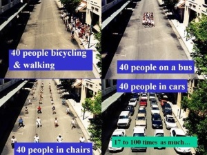
severely diminished by this level of wasteful use of land by cars—particularly in town centers (where space is so dear), and especially in communities such as Boulder, where land is so expensive.

Overemphasis on car travel breeds and spreads the gigantism “infection,” and promotes ruinously higher travel speeds. What happens when we combine the gigantism and high speeds with the “travel time budget” (humans tend to have a budget of about 1.1 hours of round-trip commuting travel each day)?

People demand larger highways and parking lots. Gigantic highways, overpasses, and asphalt seas of parking are necessary to accommodate the space-hogging, high-speed needs of the growing number of cars. This process dramatically increases the “habitat” for cars, and because such places are so utterly inhospitable to people, substantially shrinks the habitat for people.

Because it is so dangerous, unpleasant, and infeasible to travel on these monster highways by bicycle, walking, or transit (what economists call “The Barrier Effect”), an endlessly growing army of motorists and sprawl residents is thereby created, which, of course, is a financial bonanza for the Sprawl Lobby.

It is surprising and disappointing that Boulder has, on numerous occasions, shown symptoms of the gigantism disease (surprising because citizens and city staff are relatively well-informed on transportation issues). A leading concern in Boulder is the many intersections that have been expanded by installing double left turn lanes. Installing a single left turn lane historically resulted in a fair improvement in traffic flow, but when a second left turn lane is installed, intersections typically suffer from severely diminished returns. There is only a tiny increase in traffic accommodated (and often, this increase is short-lived) and this small benefit is offset by a huge required increase in walk time for crosswalks that are now very lengthy to cross on foot (which necessitates a very long “walk” phase for the crosswalk). Indeed, some traffic engineers or elected officials are so intolerant of the time-consuming long walk phase that many double-left turn intersections actually PROHIBIT pedestrian crossings by law.

These monster double left turn intersections destroy human scale and sense of place. They create a place-less, car-only intersection where walking and bicycling (and, indirectly, transit) trips are so difficult and unpleasant that more trips in the community are now by car, and less by walking, bicycling and transit. And those newly-induced car trips, despite the conventional wisdom, actually INCREASE greenhouse gas emissions (due to the induced increase in car trips).

Double left turn lanes (like big parking lots and five- or seven-lane highways) disperse housing, jobs, and shops in the community, as the intersection—at least briefly—is able to accommodate more regional car trips. Because the intersection has become so inhospitable, placeless and lacking in human scale, the double left turn repels any residences, shops, or offices from being located anywhere near the intersection, and thereby effectively prevents the intersection from ever evolving into a more walkable, compact, village-like setting.

The following chart shows that, because of the enormous space consumption caused by higher-speed car travel, land consumption rate increases are far out-pacing growth in community populations. For example, from 1950 to 1990, the St. Louis population grew by 35 percent. chartYet land consumption in St. Louis grew by 354 percent during that same period.

Given all of this, a centerpiece objective of the Boulder Transportation Master Plan (no more than 20 percent of road mileage is allowed to be congested) may not only be counterproductive in achieving many Boulder objectives, but may actually result in Boulder joining hands with the Sprawl Lobby.

The congestion reduction objective has a number of unintended, undesirable consequences. The objective tells Boulder that the highly desirable tactic of “road diets” (where travel lanes are removed to create a safer, more human-scaled street that can now install bike lanes, on-street parking, and wider sidewalks) are actually undesirable because they can increase congestion. The objective provides justification for looking upon a wider road, a bigger intersection, or a bigger parking lot as desirable, despite the well-documented fact that such gigantic facilities promote sprawl, car emissions, financial difficulties, higher taxes, and lower quality of life, among other detriments.

The objective also tells us that smaller, more affordable infill housing is undesirable—again because such housing can increase congestion.

The Shocking Revolution

The growing awareness of the problems associated with easing car travel (via such things as a congestion reduction objective) is leading to a shocking revolution across the nation. Florida, for example, now realizes that if new development is only allowed if “adequate” road capacity is available for the new development (which is based on “concurrency” rules in Florida’s Growth Management law), the state is powerfully promoting sprawl. Why? Because the available road capacity tends to only be found in sprawl locations. In-town locations, where new development tends to be much more desirable, is strongly discouraged by this Florida concurrency rule because in-town locations tend to have no available road capacity (due to existing, more dense development in town).

As an aside, “concurrency” is a rule that says new development is not allowed if it will lower service level standards adopted by the community. For example, standards might state that there must be at least 10 acres of parkland provided for every 1,000 residents. While concurrency is clearly a good idea for such things as parks and water supply and schools, it is counterproductive for roads.

The shocking revolution in Florida, then, is that the state is now allowing local governments to create “exception areas” for road congestion. If the community can show that it is providing adequate bicycle, pedestrian and transit facilities, the state will grant the local government the ability to create road exceptions so that the road congestion avoidance strategy brought by Florida’s road concurrency rule does not significantly encourage new sprawl and discourage in-town, infill development.

Similarly, California is now acknowledging the unintended, undesirable effects of past efforts to ensure that roads are “free-flowing” for car traffic. “Free flowing” car traffic tends to be measured with “level of service” (LOS) measures. Road LOS is a measure of traffic delay. An intersection (or road) where a car must wait for, say, three cycles of a traffic signal to be able to proceed through the intersection might be given an LOS rating of “F.” An intersection where a car can proceed through an intersection without such delay is given an LOS rating of “A.”

California now realizes that too often, building wider highways or stopping new development as a way to maintain free-flowing car traffic (LOS “A”) is substantially counterproductive. The state now realizes that maintaining or requiring easy, free-flowing car traffic increases greenhouse gas emissions (shocking, since the opposite was formerly believed), increases the number of car trips, and decreases the number of walking, bicycling and transit trips. Free-flowing road “LOS” measures are therefore now being phased out in California.

The “congestion reduction” objective in Boulder’s transportation plan is, in effect, a “happy cars” objective that equates easy car travel with quality of life and sustainability. One important reason why this “happy cars” objective is counterproductive is that cars and people have dramatically different needs and desires—needs and desires that are significantly and frequently in conflict. For example, designing shopping for happy people means the creation of smaller, human-scaled settings where buildings rather than parking lots are placed next to the streetside sidewalk. Where streets are only two or three lanes wide and designed for slow-speed car travel. Where street trees hug the street.

Designing shopping for happy cars, by strong contrast, requires huge car-scaled dimensions. Giant asphalt parking lots are placed between the now giant retail store and the street, which invites easy car parking (but loss of human scale, sense of place, and ease of walking). Streets become what Chuck Marohn calls “stroads”:  5- or 7-lane monster roads intended for dangerous, inhospitable high-speeds. They are roads where streets belong, but their big size and high speeds make them more like roads. Street trees are frequently incompatible with happy cars, as engineers fear cars might crash into them.

Again, this comparison shows that by promoting “happy cars,” Boulder’s congestion reduction objective is undermining its important quality of life and city-building objectives.

Indeed, Enrique Penalosa, the former mayor of Bogota, Columbia, once stated that “a city can be friendly to people or it can be friendly to cars, but it can’t be both.” Boulder’s congestion reduction objective is in conflict with this essential truth.

Fortunately, congestion regulates itself if we let it. Congestion will persuade some to drive at non-rush hour times, or take less congested routes, or travel by walking, bicycling, or transit. Congestion therefore does not inexorably lead to gridlock if we don’t widen a road or intersection, because some car trips (the “lower-value” trips) do not occur. Many of those discouraged trips are foregone because of the “time tax” imposed by the congestion.

But widening a road (or, in Boulder’s case, adding a second left-turn lane) short-circuits this self-regulation. A widened road or a double-left turn lane intersection induces new car trips because the road/intersection is now (briefly) less congested. The lower congestion encourages formerly discouraged car trips to now use the route during rush hour. Car trips that used different routes to avoid the congestion now converge back on the less congested route. And some get back in their cars after a period of walking, bicycling or using transit.

The process is very much like the infamous Soviet bread lines. The Soviets wanted to reduce the extremely long lines of people waiting for free bread. Their counterproductive “solution” was to make more free bread. But more free bread just induced more people to line up for bread. Likewise, the conventional American solution to traffic congestion is to make more free space for cars (widening the road or adding a second turn lane). The result is the same, as the bigger roads and intersections inevitably induce more car trips on those routes. The efficient and effective solution, as any first-year economics student will point out, is to NOT make more free bread or wider, free-to-use roads or second turn lanes. The solution is to price the bread and the car routes so that they are used more efficiently (and not wastefully by low-value bread consumers or car travelers). Or, to let a moderate level of congestion discourage low-value rush hour trips.

Given all of this, widening a road or adding a second left-turn lane to solve congestion is like loosening one’s belt to solve obesity. Similarly, despite conventional wisdom, car traffic does not behave like water flowing through a pipe (i.e., flowing easier if the pipe is expanded in size). Car traffic, instead, behaves like a gas. It expands to fill the available, increased volume provided.

Boulder’s Overriding Objectives

Boulder (and PLAN-Boulder County) has outlined key community objectives.

1. One is higher quality of life and more happiness. But counterproductively, happy cars lower quality of life due to clashing values and needs.

2. Another objective is for a more compact, walkable, vibrant city. Unfortunately, over-emphasizing cars means more sprawl.

3. An objective that is much talked about in the area is more affordability. By inducing more car dependence via easier car travel, the congestion reduction objective undermines the affordability objective by making Boulder less affordable (more on that later).

4. Given the growing concern for global warming, Boulder is placing more emphasis on reducing greenhouse gas emissions. Easing traffic congestion, however, induces new car traffic, which increases car emissions.

5. Boulder and PLAN-Boulder County seek more travel (and lifestyle) choices. But the congestion reduction objective in Boulder’s plan is again undercutting other objectives because it leads to bigger car infrastructure (bigger roads and intersections), thereby reducing travel and lifestyle choices.

As shown above, then, Boulder’s congestion reduction objective undermines each of these five essential community objectives.

Oops.

Conventional methods of reducing congestion include wider roads, bigger parking lots, one-way streets, and huge intersections. These tactics are a “win-lose” proposition. While they can reduce congestion (briefly), they also cause a loss of human scale and charm; a loss of social gathering; sprawling dispersal; more car dependence and less bicycling, walking, transit; higher taxes; economic woes (for government, shops and households); a decline in public health; and more air pollution.

By striking contrast, other less commonly used but much more beneficial transportation tactics are “win-win” propositions. Some of these tactics include road diets, designing streets for slower speeds, and designing for travel and lifestyle choices. They can result in:

  • More parking spaces
  • More civic pride (induced by human scale)
  • More social gathering
  • A more compact and vibrant community
  • Less car dependence and more bicycling, walking, and transit
  • Lower taxes
  • Economic health (for both government and households)
  • Improvement in public health
  • Less air pollution

If we can’t get rid of congestion, what CAN we do? We can create alternatives so that those who are unwilling to tolerate the congestion can find ways to avoid it. Congestion can be better avoided if we create more housing near jobs, shops, and culture. Doing this allows more people to have better, more feasible ways to travel without a car. We can also create more travel routes, so that the congested routes are not the only routes to our destinations. Some of us can be given more flexible work schedules to shift our work hours away from rush hour. And some of us can be given increased opportunities to telecommute (work from home).

How Can We Design Transportation to Achieve a Better Destiny?

An important way to start Boulder on a better destiny for the city is to revisit the “No more than 20 percent congested road miles” objective in the Boulder transportation master plan. Some possibilities: adopt a “level of service standard” not for cars, but for bicycle, walking and transit travel; “Level of service” standards for cars is becoming outdated because it is being increasingly seen as counterproductive, as described earlier. Other alternatives to the “congestion” objective is to have a target of controlling or reducing vehicle miles traveled (VMT) community-wide; or set a goal of minimizing trip generation by individual new developments in the city.

Another option is to keep the congestion objective, but create “exception” areas where the congestion rule does not apply. Those exception areas would be places where Boulder seeks to encourage new development.

Boulder needs to ensure that the community land development and transportation design tactics are appropriately calibrated within each “transect zone” of the community. (The “transect” principle identifies a transition from urban to rural, whereby the town center is more compact, formal, low-speed, and walkable; the suburbs are more dispersed, informal, higher-speed, and drivable; and the rural areas most remote from the town center are more intended for a farming and conservation lifestyle. Development regulations and transportation designs are calibrated so that the differing lifestyle and travel objectives of each zone are best achieved.) However, the difficulty with the transect principle in places like Boulder is that the demand for compact, walkable lifestyles and travel choices is much higher than the supply of such places in Boulder. There is, in other words, a large mismatch. By contrast, the supply of suburban, drivable areas is quite high. To correct this imbalance, Boulder should strive to create a larger supply of compact, walkable places similar to Pearl Street Mall, the Boulder town center, and even the CU campus. Opportunities now being discussed are the creation of new, compact villages and town centers at places such as street intersections outside of the Boulder town center.

As an aside, the community transect concept informs us that in the town center, “more is better.” That is, the lifestyle being sought in the community center is one where more shops, more offices, and more housing enhances the lifestyle, as this more proximate, mixed, compact layout of land uses provides the thriving, sociable, convenient, vibrant, 24-hour ambience that many seeking the walkable lifestyle want more of.

By contrast, in the more drivable suburbs, “more is less.” That is, the drivable lifestyle is enhanced in quality when there is less density, less development, more dispersal, and more isolation of houses from shops and offices. The ambience generally desired is more quiet and private.

While town center housing is increasingly expensive compared to the suburbs—particularly in cities such as Boulder—such in-town housing provides significant cost savings for transportation. Because such a housing location provides so many travel choices beyond car travel, many households find they can own two cars instead of three or one car instead of two. And each car that a household can “shed” due to the richness of travel choices provides more household income that can be directed to housing expenses such as a mortgage or rent. Today, the average car costs about $9,000 per year to own and operate. In places that are compact and walkable, that $9,000 (or $18,000) per year can be devoted to housing, thereby improving affordability.

In addition to providing for the full range of housing and travel choices, Boulder can better achieve its objectives through road diets, where travel lanes are removed and more space is provided for such things as bike lanes or sidewalks or transit. Road diets are increasingly used throughout the nation—particularly converting roads from four lanes to three. Up to about 25,000 vehicle trips per day on the road, a road that is “dieted” to, say, three lanes carries about as much traffic as a four-lane road. This is mostly due to the fact that the inside lanes of a four-laner frequently must act as turn lanes for cars waiting to make a left turn. Four-lane roads are less desirable than three-lane streets because they induce more car trips and reduce bicycle, walking and transit trips. Compared to three-lane streets, four-lane roads result in more speeding traffic. As a result, four-laners create a higher crash rate than three-lane streets. Finally, because the road-diet (3)three-lane street is more human-scaled, pleasant, lower-speed, and thereby place-making, a three-lane street is better than a four-lane street for shops. The three-lane street becomes a place to drive TO, rather than drive THROUGH (as is the case with a four-lane street).

If Boulder seeks to be transformative with transportation—that is, if the city seeks to significantly shift car trips to walking, bicycling and transit trips (rather than the relatively modest shifts the city has achieved in the past)—it must recognize that it is NOT about providing more bike paths, sidewalks, or transit service. It is about taking away road and parking space from cars, and taking away subsidies for car travel.

Another transportation tactic Boulder should pursue to achieve a better destiny is to unbundle the price of parking from the price of housing. People who own less (or no) cars should have the choice of opting for more affordable housing—housing that does not include the very expensive cost of provided parking. Currently, little or no housing in Boulder provides the buyer or renter the option of having lower cost housing payments by choosing not to pay for parking. Particularly in a place like Boulder, where land values are so high, even housing intended to be relatively affordable is more costly than it needs to be because the land needed for parking adds a large cost to the housing price. Indeed, by requiring the home buyer or renter to pay more for parking, bundled parking price creates a financial incentive for owning and using more cars than would have otherwise been the case.

Boulder should also strive to provide parking more efficiently by pricing more parking. Too much parking in Boulder is both abundant and free. Less parking would be needed in the city (which would make the city more affordable, by the way) if it were efficiently priced. Donald Shoup recommends, for example, that parking meters be priced to ensure that in general, 2 or 3 parking spaces will be vacant on each block.

Efficient parking methods that could be used more often in Boulder include allowing shops and offices and churches to share their parking. This opportunity is particularly available when different land uses (say churches and shops) don’t share the same hours of operation. Again, sharing more parking reduces the amount of parking needed in the city, which makes the city more compact, walkable, enjoyable and active.

Like shared parking, leased parking allows for a reduction in parking needed. If Boulder, for example, owns a parking garage, some of the spaces can be leased to nearby offices, shops, or housing so that those particular land uses do not need to create their own parking.

Finally, a relatively easy and quick way for Boulder to beneficially reform and make more efficient its parking is to revise its parking regulations so that “minimum parking” is converted to “MAXIMUM parking.” Minimum parking rules, required throughout Boulder, are the conventional and increasingly outmoded way to regulate parking. They tell the developer that at least “X” amount of parking spaces must be provided for every “Y” square feet of building. This rule almost always requires the developer to provide excessive, very expensive parking, in large part because it is based on “worst case scenario” parking “needs.” That is, sufficient parking must be provided so that there will be enough on the busiest single day of the year (often the weekend after Thanksgiving). Such a provision means that for the other 364 days of the year, a large number of parking spaces sit empty, a very costly proposition.

In contrast, maximum parking rules tell the developer that there is an upper limit to the number of spaces that can be provided. This works much better for the community and the business because the business is better able to choose how much parking it needs and can finance. Since financial institutions that provide financing for new developments typically require the developer to provide the conventional (read: excessive) amounts of parking as a condition for obtaining a development loan, the big danger for communities in nearly all cases is that TOO MUCH parking will be provided rather than too little. The result of setting “maximum” instead of “minimum” parking rules is that excessive, worst case scenario parking developments become much more rare.

The reform of parking is easy: simply convert the existing minimum parking specifications to maximum parking standards (“at least 3 spaces per 1,000 square feet” becomes “no more than 3 spaces per 1,000 square feet). An incremental approach to this conversion is to apply maximum parking rules in those places that are already rich in travel choices, such as the Boulder town center.

Again, what will Boulder’s destiny be? As the preceding discussion sought to demonstrate, much of that destiny will be shaped by transportation decisions.

Will destiny be shaped by striving for happy people and happy places for people? Or will it be shaped by opting for the conventional, downwardly-spiraling effort of seeking easy car travel (and thereby unpleasant places where only a car can be happy – such as huge highways or parking lots)?

Will Boulder, in other words, retain or otherwise promote place-less conventional shopping centers full of deadening parking, car-only travel, lack of human interaction, and isolation? Or will the city move away from car-happy objectives such as the congestion reduction policy, and instead move toward a people-friendly future rich in sociability, pride in community, travel choices, sustainability, place-making and human scale?

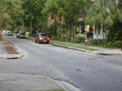
An example of these contrasting destinies is Pearl Street. West Pearl features the charm and human scale we built historically. West Pearl Street exemplifies a lovable, walkable, calm, safe and inviting ambience where car speeds are slower, the street is more narrow, and the shops—by being pulled up to the streetside sidewalk—help form a comfortable sense of enclosure that activates the street and feels comfortable to walk. The shops tend to be smaller—more neighborhood-scaled.

East Pearl Street near 28th Street is starkly different. There, the street is a “stroad,” because it is an overly wide road that should be a more narrow, lower-speed street. Shops are pulled back long distances from the street. The street here is fronted not by interesting shop fronts but enormous seas of asphalt parking. The layout is car-scaled. The setting is hostile, unpleasant, unsafe, stressful and uninviting. The shops tend to be “Big Box” retail, and serve a regional “consumershed.” There is “no there there.”

East Pearl Street was built more recently by professional planners and engineers who have advanced degrees that far exceed the professionalism and education of those who designed the more lovable West Pearl Street. Where has the charm gone? Why have our streets become less pleasant in more recent years (by better trained and better educated designers, I might add)? Is it perhaps related to our more expensive and sophisticated efforts to ease car traffic and reduce congestion?

There is an inverse relationship between congestion and such measures as vehicle miles traveled and gas consumption. At the community level—despite the conventional wisdom—as congestion increases, vehicle miles traveled, gas consumption, air emissions DECREASE. And as conventional efforts to reduce congestion intensify, quality of life and sustainability also decrease.

Again, is Boulder aligning itself with the Sprawl Lobby by maintaining an objective of easing traffic flow – by striving to reduce congestion?


On Controlling Size

David Mohney reminds us that the first task of the urban designer is to control size. This not only pertains to the essential need to keep streets, building setbacks, and community dispersal modest in size. It also pertains to the highly important need to insist on controlling the size of service and delivery trucks. Over-sized trucks in Boulder lead the city down a ruinous path, as street and intersection dimensions are typically driven by the “design vehicle.” When trucks are relatively large, excessive truck size becomes the “design vehicle” which ends up driving the dimensions of city streets. A healthy city should be designed for human scale and safety, not for the needs of huge trucks. Indeed, because motor vehicles consume so much space, a sign of a healthy, well-designed community is that drivers of vehicles should feel inconvenienced. If driving vehicles feels comfortable, it is a signal that we have over-designed streets and allocated such excessive spaces that we have lost human scale and safety.

A proposal for human-scaled streets: in Boulder’s town center, no street should be larger than three lanes in size. Outside the town center, no street should be larger than five lanes in size. Anything more exceeds the human scaling needed for a pleasant, safe, sustainable community.

It is time to return to the timeless tradition of designing to make people happy, not cars. Boulder needs to start by revisiting its congestion reduction objective, putting a number of its roads on a “road diet,” and taking steps to make the provision of parking more efficient and conducive to a healthy city.

__________________________________

 More about the author

 Mr. Nozzi was a senior planner for Gainesville FL for 20 years, and wrote that city’s long-range transportation plan. He also administered Boulder’s growth rate control law in the mid-90s. He is currently a member of the Boulder Transportation Advisory Board.

 Studies Demonstrating Induced Traffic and Car Emission Increases

Below is a sampling of references to studies describing how new car trips are induced by easier car travel, and how car emissions increase as a result.

http://www.sierraclub.org/sprawl/articles/hwyemis.asp

http://www.vtpi.org/gentraf.pdf

http://en.wikipedia.org/wiki/Induced_demand

http://walkablestreets.wordpress.com/1993/04/18/does-free-flowing-car-traffic-reduce-fuel-consumption-and-air-pollution/

TØI (2009), Does Road Improvement Decrease Greenhouse Gas Emissions?, Institute of Transport Economics (TØI), Norwegian Centre for Transport Research (www.toi.no); summary at www.toi.no/getfile.php/Publikasjoner/T%D8I%20rapporter/2009/1027-2009/Sum-1027-2009.pdf

Robert Noland and Mohammed A. Quddus (2006), “Flow Improvements and Vehicle Emissions: Effects of Trip Generation and Emission Control Technology,” Transportation Research D, Vol. 11 (www.elsevier.com/locate/trd), pp. 1-14; also see

www.cts.cv.ic.ac.uk/documents/publications/iccts00249.pdf

Clark Williams-Derry (2007), Increases In Greenhouse-Gas Emissions From Highway-Widening Projects, Sightline Institute (www.sightline.org); at

www.sightline.org/research/energy/res_pubs/analysis-ghg-roads

TRB (1995), Expanding Metropolitan Highways: Implications for Air Quality and Energy Use, Committee for Study of Impacts of Highway Capacity Improvements on Air Quality and Energy Consumption, Transportation Research Board, Special Report #345 (www.trb.org)

D. Shefer & P. Rietvald (1997), “Congestion and Safety on Highways: Towards an Analytical Model,” Urban Studies, Vol. 34, No. 4, pp. 679-692.

Alison Cassady, Tony Dutzik and Emily Figdor (2004). More Highways, More Pollution: Road Building and Air Pollution in America’s Cities, U.S. PIRG Education Fund (www.uspirg.org).

http://www.opr.ca.gov/docs/PreliminaryEvaluationTransportationMetrics.pdf


Leave a comment

Filed under Bicycling, Economics, Energy, Environment, Miscellaneous, Peak Oil, Politics, Road Diet, Sprawl, Suburbia, Urban Design, Walking

A Pedestrian Call to Arms: A Manifesto

By Dom Nozzi

Each year, America experiences an outrageous carnage due to car crashes. In 2011, 4,432 pedestrians were killed and 69,000 were injured in traffic crashes.

Such bloodshed is incompatible with a civilized society. Are we too barbaric to do what is necessary to end this slaughter? Will we continue to blame the victim?

For several decades, there have been organized advocacy groups for bicycling. For transit. For environmental conservation. For local businesses.

But there is no group lobbying for the needs of pedestrians.

This is very bad news for the health of cities, because particularly in a town center, the pedestrian is the design imperative.

Below is a manifesto I have written that I hope is a step toward rectifying this ruinous disregard for the pedestrian.

 A Pedestrian Manifesto

Our community strives to protect and promote a walkable lifestyle as its design imperative. We believe that future development in areas of our community intended to be walkable should make walkability the primary emphasis of design. It is the lynchpin for the quality of life in the walkable areas of our community, for a quality transit system, for safety, for travel choice, for affordability, for human scale, for civic pride, for sustainability, for public health, for environmental conservation, and for the protection and enhancement of property values.admin-ajax (9)

Given these overwhelmingly beneficial outcomes for a walkable community, we have adopted the following manifesto which, to the extent possible, should be followed in all actions taken by the public and private sector for projects in the areas that out community intends to preserve and promote as walkable.

Most imperatively, improving walkability (and civic pride, comfort, convenience and sociability) means scaling down spaces in places we intend to be walkable. This “human-scaled” need acknowledges that in American cities, our walkability problem is that we have TOO MUCH space. Too much distance. Not that we have too much in the way of parks or squares or plazas or other “open spaces,” but that we have buildings that are set back too far from sidewalks. Too many “sea of asphalt” parking lots. Roads that contain too many travel and turn lanes. Too much distance between the home both neighbors and the corner store.

Our first and most important task for creating the walkability that people the world over love in places like Rome, Siena, Paris, and Venice, is to create human-scaled city spaces – particularly in our town centers. A large number of roads need to be put on a “road diet” by removing travel lanes and calming down (slowing) the speed of cars so that streets are welcoming, safe and sociable. Buildings need to be pulled up to the streetside sidewalk. Parking lots need to be shrunk in size—preferably by replacing some of them with active buildings, and moving more of them to on-street parking spaces. Streets need to be gracefully enveloped by street trees. Houses need to be mixed with shops and offices.

Most of these design practices were followed for most of human history (in America, up until approximately World War II). It is time to start returning to that tradition.

Neighborhood Streets

In general, the following principles shall be used:

A. Streets should be two-way. Existing one-way streets should be restored to two-way operation.

B. Streets should be modest in width. Turning radii should be modest in size.

C. On-street parking should be encouraged to the extent possible over off-street parking.

D. Design speeds should be relatively modest.

E. Emergency service and public service vehicle needs should be secondary to the quality of life and life safety needs.admin-ajax (10)

F. Particularly in areas affected by spillover parking, parking should be priced (metered) or allowed only by permit. Pricing should be calibrated for 85% occupancy, and the revenue returned to neighborhoods for neighborhood improvements.

Larger Regional and Main Streets

In general, the following principles shall be used:

A. Streets should be a maximum of 3 lanes in size, and those which are larger should be reduced to 3 lanes.

B. To promote permeability and walkability, mid-block crossings should be designed at regular intervals in locations near walkable neighborhoods and in town centers.

C. Traffic signals are preferably post-mounted and should be relatively modest in height.

D. Design speeds should be relatively modest.

E. Turning radii for these streets should be relatively modest.

F. On-street parking is the preferred form of parking, and parking meters used to achieve an 85% occupancy rate. Revenues from these meters should be used for the neighborhood where the meters are placed.admin-ajax (11)

G. To the extent possible, these streets should contain raised, low-maintenance medians.

Street Lights

In general, the following principles shall be used:

A. Street lights should be relatively modest in height and historic in character.

B. Street lights should be full cut-off.

C. Street lights should maximize full color spectrum, such as Halogen.

D. Because they are the most invisible color in the landscape, street light structures (and other public equipment) should typically be black in color.admin-ajax (12)

Sidewalks

In general, the following principles shall be used:

A. As soon possible, the community should fill remaining sidewalk gaps in neighborhoods.

B. Sidewalk gap filling should be a significantly higher priority than sidewalk repair.

C. In town centers, the trajectory of sidewalks should be rectilinear rather than curvilinear.

Building Disposition in Town Centers

In general, the following principles shall be used:admin-ajax (13)

A. Buildings should butt up to the sidewalk, face the sidewalk with a main entrance, contain sufficient windows along the sidewalk, and have a first floor that is at least 10 feet in height.

B. Buildings should be parallel to the street, rather than rotated.admin-ajax (14)

C. Buildings should be encouraged to be at least two stories in height and mixed in use (retail, office and residential).

D. High levels of building ornamentation should be encouraged.

E. Auto parking should never be in front of a building.

 Homeless Population

In general, because the homeless/panhandling population is an important impediment to walking, the following practices should be employed:

A. Minimize or reduce the number of free meals provided in town centers.

B. Enforce the “no sleeping in public parks” law.

C. Use park facilities that discourage sleeping.

D. Consider adopting a “no smoking” law for parks and other public spaces.

Street Trees

In general, the following principles shall be used:

A. The community should install and maintain a dense, formally aligned, large, canopy trees along streets.

B. Trees of the same species or at least the same size and shape should be used along individual streets. Tree diversity should only be established, if necessary, from street to street.

C. Tree pruning along power lines should be consistent with practices described in “Trees in Urban admin-ajax (15)Design,” by Henry Arnold (1985).

Parking

In general, the following principles shall be used:

A. To the extent possible, and as soon as possible, existing surface parking lots in and near town center neighborhoods should be converted to buildings.

B. Multi-family housing developments in and near walkable neighborhoods should “unbundle” the price of parking from the cost of the housing so that those who choose not to own a car are not forced to pay for expensive, unneeded, ugly, unwalkable parking.

C. Parking requirements should be relaxed in and near walkable neighborhoods. “Minimum” parking regulations for new development should be converted to “maximum” parking requirements, for example.

Summary

By adhering to these design guidelines, our community will be dramatically safer, more pleasant, more instilled with civic pride, more physically fit, more sustainable, more equitable, more affordable and more prosperous. These guidelines are essential if we ever hope to be able to dramatically reduce the utterly barbaric, unacceptable number of pedestrian injuries and deaths we experience each year.

Leave a comment

Filed under Road Diet, Sprawl, Suburbia, Transportation, Urban Design, Walking

Designing Streets for Safety

By Dom Nozzi

In September 2007, a citizen in Micanopy, Florida asked me about whether a large “vision triangle” was a good idea at a street intersection. A vision triangle is an imaginary triangle drawn at the corners of an intersection that is to be clear of “visual obstructions” such as buildings or fences or signs.visibilitysmall

I informed this person that in general, the need for a vision triangle arose in the 20th Century, when engineers began to design “forgiving roads” to try to safely accommodate higher speed, reckless, incompetent, inattentive driving of cars and trucks. Such a design paradigm assumes that drivers will always drive at high speeds in a reckless, incompetent, inattentive way.

I believe this concept is increasingly being seen as flawed. It is a self-fulfilling prophecy that inevitably results in the growth of higher speed, reckless, incompetent and inattentive driving.

Drivers drive at the highest speed at which they feel safe. They also devote as much attentiveness as is deemed necessary, and no more. Therefore, if we design roads that “forgive” high speed and inattentive driving by moving trees/vegetation/buildings away from the street with a large vision triangle, a growing number of drivers will consequently drive at higher speeds and less carefully, because they can now do so more safely.

There is now a growing call, which I strongly support, that suggests we should reverse this safety strategy. After all, the track record of this form of conventional safety engineering has been awful over the past several decades. Crashes have not declined, and drivers drive faster and more recklessly.

The new paradigm, which I believe will result in a safer transportation system, is one that obligates motorists to drive carefully. To drive more attentively. More slowly.

In a compact, walkable town center, which needs to be low-speed in design, we need to return to the tradition of designing for the Attentive Street, not the Forgiving Street. Buildings, vegetation (particularly street trees) and fences needs to be moved close to the street. Vision triangles should be quite modest in size.

The dilemma is that at first glance, it would seem that a larger vision triangle promotes safety, since the motorist can see a larger area of potential threats such as other motor vehicles on the crossing street. But counterintuitively, the opposite is true, as I demonstrated above.

Woonerf in Binghamton


For safetly, motorists should find streets that require them to drive slower

and more carefully in order to feel safe. By being obligated to be slower and more careful, safety increases.

This is the opposite of what engineers have been trained to believe over the past several decades, so many continue to ferociously oppose such a design shift.

In sum, assuming we are designing a street that would appropriately have a relatively low design speed of 10-20 mph, I would urge the vision triangle to be extremely small. Larger triangles encourage less safe, higher speed, less attentive turns and cruising speeds by motorists.

Would Stop Signs Increase Safety?

In general, stop signs are not a recommended treatment for slowing cars or increasing safety (or making a larger vision triangle safer). Stop signs can create a false sense of security and are often disregarded. Better treatments would include horizontal, physical interventions such as a traffic circle, a roundabout, narrower travel lanes, bulb-outs, on-street parking, speed tables, etc. In other words, as I noted above, designs that obligate the motorist to drive more slowly and attentively. Stop signs do not do that.

To achieve this slower, more attentive and safe street design, it is important to work with an engineer who is sympathetic to the Attentive Street design paradigm. I recommend designers such as Michael Ronkin, Dan Burden, Michael Wallwork, Walter Kulash, or Ian Lockwood.

Low design speeds not only improve street safety. They also improve retail health. They create “drive-to” shopping streets rather than “drive-through” escape routes.

_____________________________________

Visit my urban design website read more about what I have to say on those topics. You can also schedule me to give a speech in your community about transportation and congestion, land use development and sprawl, and improving quality of life.

Visit: www.walkablestreets.wordpress.com

Or email me at: dom[AT]walkablestreets.com

50 Years Memoir CoverMy memoir can be purchased here: Paperback = http://goo.gl/9S2Uab Hardcover =  http://goo.gl/S5ldyF

My book, The Car is the Enemy of the City (WalkableStreets, 2010), can be purchased here: http://www.lulu.com/product/paperback/the-car-is-the-enemy-of-the-city/10905607Car is the Enemy book cover

My book, Road to Ruin, can be purchased here:

http://www.amazon.com/Road-Ruin-Introduction-Sprawl-Cure/dp/0275981290

My Adventures blog

http://domnozziadventures.wordpress.com/

Run for Your Life! Dom’s Dangerous Opinions blog

http://domdangerous.wordpress.com/

My Town & Transportation Planning website

http://walkablestreets.wordpress.com/

My Plan B blog

https://domz60.wordpress.com/

My Facebook profile

http://www.facebook.com/dom.nozzi

My YouTube video library

http://www.youtube.com/user/dnozzi

My Picasa Photo library

https://picasaweb.google.com/105049746337657914534

My Author spotlight

http://www.lulu.com/spotlight/domatwalkablestreetsdotcom


Leave a comment

Filed under Urban Design

Interview with the Bloomington (Indiana) Alternative

By Dom Nozzi

The following is an October 2007 interview with the Bloomington Alternative.

Bloomington Alternative (BA): While your book & work addresses broader issues of urban planning, your focus seems to be upon making cities more walkable or pedestrian-friendly. How do you keep bicyclists from being forsaken in the tension between motorists & walkers?

Dom Nozzi (DN): I should start by pointing out that I have a bachelor’s in environmental science and a masters in planning. My masters thesis was bicycle transportation. In my over 21 years as a professional city planner, I have been a regular bicycle commuter. In fact, I have never in my life driven a car to work, and have only owned a car for a year and a half (and that was a long time ago).

About 15 years ago, in my work as a planner, I had an astonishing, crucial epiphany: In a town center (or downtown), the pedestrian is the design imperative. Everything else is secondary, if we are to have a healthy community. In the town center, the pedestrian is the lynchpin. If we successfully design for a quality pedestrian environment, we synergistically and inevitably create a better environment for transit, for bicyclists, for seniors, for children, for businesses, for the environment, and, ultimately, even for motorists.

I am convinced, therefore, that bicyclists are not forsaken if we design well for peds. Indeed, I believe conditions for bicyclists are greatly improved. Two quick examples: Quality pedestrian design requires low-speed car travel and proximity to destinations. Both of those elements are essential for meaningful levels of high-quality bicycling to occur.

BA: As mentioned on your website, there is an emerging concept in urban design known as a “transect” that essentially is a way of classifying different kinds of neighborhoods along a continuum, from rural to Bloomington co courthouse6suburban to city neighborhood to downtown that prescribes the idea that things that belong in one zone would be out of place in another.

DN: Yes, the transect is one of the most fertile, important concepts I have learned in my career as a planner. Another way of describing it: There is a place for everything and everything has its place (although this is not precisely true, as some of us may argue that there is NO place for, say, a nuclear power plant…).

BA: Among the features that you attribute to making the “urban core” more walkable are on-street parking & the absence or removal of bike lanes, as, “Bicycle lanes tend to increase the crossing distance for pedestrians, and are often incompatible with on-street parked cars unless an excessively wide bicycle lane is created.”

What would you define as an “excessively wide bicycle lane”? Is not the call for on-street parking centered around the idea that it is more convenient for motorists to become pedestrians when they can park on the street?

DN: An excessively wide bicycle lane in this context is one which creates a street width that results in motorists occasionally using the bicycle lane as a car travel lane. Excessive bicycle lane width in this context also occurs if the width creates a “racetrack” character (which results in a motorist tendency to engage in speeding). Finally, excessive width is a width that detracts from the “sense of enclosure” that is so important in creating a high-quality, walkable town center. As Gertrude Stein so famously said about a dead or dying downtown, “there is no ‘there’ there.” What she meant was that there was no sense of place. A sense of place is most effectively achieved by creating a human-scaled ambience in a town center (and perhaps elsewhere). Human scale, in part, means that streets and intersections are relatively narrow. One important result of creating a human-scaled town center is that streets are low-speed. Cars are obligated to travel slowly and attentively. One of the most powerful, beneficial ways to create a low-speed, human-scaled, walkable town center is to install as much on-street parking as is feasible. Some important benefits of on-street parking: They create friction, which slows cars. They create a human-scaled sense of enclosure (they are place-makers). They reduce dangerous, inattentive speeding by motorists.

BA: One of the excuses used by city planners when denying requests for more bikable streets is that not very many people ride bicycles as their primary mode of transit, but is that not the result of urban planning based around autos & the bi-peds in those autos?

DN: In a sense, it is absolutely true that nearly all city planners and traffic engineers are motorists who, as motorists, think and see as motorists (rather than being public servants who have the task of improving the community quality of life for all). By single-mindedly designing for happy motoring, planners and engineers (unintentionally?) make conditions more difficult for bicyclists, transit users and pedestrians. Economists call this the “barrier effect.” Roads have too many travel lanes and are too high-speed. There is too much auto parking. Homes are too far away from jobs and shops and parks and the street.

Note, however, that most planners and engineers have the knowledge about how to create more bikable streets. They fail to make bike-friendly recommendations not just because they are utterly dependent on car travel themselves, but also because they have not been given PERMISSION to make bike-friendly recommendations by their supervisors and their elected officials.

How is that permission most likely to be granted? One way is by electing a courageous leader who has the wisdom to create a better community (I know, I know. This is nearly impossible). Another way is to create a growing army of former motorists who are now (or would like to be) bicyclists, pedestrians and transit users. How is such an army created? Not with bike lanes, or sidewalks or free transit passes. While those things may help a bit, the most significant way to create more bicyclists, pedestrians and transit users is, by far, to ensure that the car parking in your community is scarce and properly priced (ie, provided efficiently). That you have sufficiently higher density, mixed-use development. And that your streets are low-speed and no more than 3 lanes in size. These tactics are not easy and will not happen overnight. Which helps explain why nearly all Americans travel by car, and why we too often use relatively ineffective, path-of-least-resistance strategies such as installing bike parking or sidewalks.

BA: Why the concern about bike lanes making pedestrian crossings a few feet longer & not on-street parking making pedestrian crosswalks wider?

DN: On-street parking typically reduces the width of pavement containing moving cars. By contrast, in a town center that we hope to make more walkable, bike lanes can increase the width of pavement containing moving cars (or will create the “racetrack” which induces motorists to drive at higher, more inattentive speeds). Furthermore, as I noted above, on-street parking increases the “friction” that motorists perceive, which slows them. In a town center, a bike lane can reduce friction, which can induce speeding.

BA: On your website, you acknowledge that when a walkable, compact urban location contains major (arterial) streets that such streets generally require the installation of in-street bicycle lanes, but you state that, “When such major streets require bike lanes, it is a strong indication that the street itself is a transect violation. Also incompatible in this location are bicycle paths separate from the street. Such paths are not only unaffordable to install in this location, but significantly increase bicyclist danger.”

As stated elsewhere in your work, you attribute this hightened danger both to inattentiveness on the part of motorists & the invisibility & false sense of security of the bicyclists.

Are not these psychological dimensions of driver & rider attentiveness at the core of many traffic accidents, irrespective of road conditions?

DN: Road conditions are, by far, the primary origin of driver behavior. The attentiveness, skill and safety of motorists is largely the result of how the road is designed. It is NOT because “Americans” or [fill in the name of your community] are genetically predisposed to poor or unsafe driving. As I note in my forthcoming book, this erroneous assumption that Americans are poor and dangerous drivers has resulted in the catastrophic mistake of the traffic engineering profession adopting the “forgiving road” paradigm — which, ironically, creates less safe roads.

BA: Is not the “affordability” of infrastructural changes very subjective, given the great disparity of respective annual expenditures for bike-centered & auto-centric design?

DN: Absolutely. Only an inequitably tiny amount of public dollars are allocated to bikes/peds/transit compared to cars. But this unfortunate situation is extremely unlikely to change unless, again, we have courageous leadership or we establish the controlling, independent variables (the lynchpins) I mention above, such as scarce/priced car parking, modest roads, etc. Only those things will lead to a meaningful change in funding.

BA: Riding bikes on sidewalks is technically illegal, though rarely enforced, & bicyclists are expected to ride with traffic in the right third of the auto traffic lane & often keep to the very right of the lane since it is difficult for cyclists to tell whether the drivers see them or not, often subjecting cyclists to navigating debris, sewage grates & the opening of doors & the backing out of motorists using on-street parking.

What about these concerns, common to the average cyclist?

DN: In a town center, biking on a sidewalk is dangerous. In addition, unless the bicyclist is riding at a pedestrian speed, bikes and peds don’t mix well. In this part of the community, if it is properly designed for low-speed walkability, it is perfectly safe and comfortable for the bicyclist to “share the lane” with the motorist. In such riding, there is no need for concern about road debris, since it has been swept by cars. In higher speed suburbs, a wide curb lane (14-16 feet wide) w/o a painted bike lane line is best, since this ensures periodic motorist sweeping of the area bicyclists ride in. Less desirable is a painted bike lane, which is hardly ever swept by motorists. I am somewhat sympathetic to painted bike lanes, however, because they are more likely to encourage novice bicyclists to become bike commuters. Bike lanes also send the important message that “this is a bike-friendly community.” (they can also reduce the “racetrack” problem, BTW).

BA: You state that you also generally oppose bike lanes in suburban areas, thusly, “In general, bicycle lanes are not necessary on intermediate (collector) streets, due to low traffic volumes. Like walkable urban locations, bicycle paths separate from the street are generally incompatible in this location.” Why is the mode of bicycling always subjugated to the needs of motorists?

DN: In general, I believe that the most appropriate place for bike lanes is in suburbs (particularly higher speed arterial — major — streets). In suburban, lower-speed neighborhoods, bike lanes usually become superfluous, as it is perfectly safe for the bicyclist to share the lane with cars. And yes, in suburbs we find a relatively large number of intersections and driveways (more so than in rural/preservation areas), which makes off-street bicycle paths less appropriate. It is not clear to me how any of this pertains to the “needs of motorists”.

BA: Are not the higher vehicle speeds & “low traffic volumes” (affecting sense of security/driver attentiveness) of suburban roadways actually more dangerous for bicyclists?

DN: Yes, as speeds increase in suburban locations, bike lanes become more important and appropriate. It all depends on context and the design speed of the road.

BA: Would not bicycle lanes in semi-urban & suburban areas grant greater safety to cyclists due to their separation from commuting motorists with cell-phones & in-car DVD players?

DN: Yes. See above.

BA: Aside from downtown merchantile districts, sprawl malls & school routes, what other areas really need greater walkability?

DN: Other than in a town center, walkability should be provided whenever and wherever the residential and non-residential market call for it. This can include inner (and older) suburbs and new urbanist neighborhoods built in suburban locations. Should a suburban neighborhood desire it, suburban areas can also be retrofitted to a small degree by being more walkable.

Note that once the significant market distorting subsidies (large and “free” roads, “free” and abundant parking, etc.) whither away, the societal interest in walkability will grow substantially. Large numbers will either try to move to walkable town centers or see that their suburban areas are retrofitted to be more walkable.

BA: Have you ever considered that one dimension that intersects these “transects” or planning zones is that of people in wheel chairs, who regularly encounter curbs without ramps & obstacles to sight lines at intersections & impediments to wheeled travel along sidewalks. What can be done to make streets & sidewalks more wheelchair accessible?

DN: Engineers and planners need to do a “wheelchair audit” by trying to get around in a wheelchair so they can see how many obstacles people face when using a wheelchair. I am fully supportive of most curb intersection ramps and being sure that sidewalk/crosswalk surfaces contain smoothness.

Note that wheelchair users are significantly better off when high-quality, compact, walkable town centers are built, since nearly all destinations become proximate and therefore more accessible. And cars move more slowly.

BA: Would you favor more sidewalks, crosswalks & bridges over by-passes & around retail plazas & hotels along interstates?

DN: I am always supportive of filling sidewalk gaps in town center and suburban locations. And I am a firm supporter of creating more complete streets. Pedestrian overpasses are rarely a good idea, unless we are talking about a roadway that is too dangerous to cross at-grade, such as an Interstate. Such overpasses in other locations tend to be expensive, particularly when they go mostly unused (largely because it is easier and quicker to cross at-grade).

In addition, there is little that American communities need more than an increase in pedestrians. It therefore seems to me to be a strategic blunder to remove even more of the few pedestrians we have in our towns from our nearly empty sidewalks and putting them in overpasses. Pedestrians, as AASHTO points out, are the lifeblood of a city. People by their very nature enjoy the sociability of a sidewalk bustling with pedestrians (as do small retailers). Finally, an overpass tells us that we have given up on restoring the livability and quality of our street. We shall forever give it over to the car.

BA: How do you feel about cul-de-sacs & obstacles at intersections as traffic abatement?

DN: Cul-de-sacs are extremely undesirable and should only be permitted when it is impossible to create a connected street (due to environmental factors). Such design externalizes costs on other streets, because cul-de-sac residents must drive more (and do so on streets other than the one they live on). They reduce trips by bicycle, walking and transit, because they tend to increase travel distances. They increase driver inattentiveness. They reduce child “street skills.” They increase the cost of public service delivery.

As for “obstacles,” I am not clear what you mean. If you are referring to treatments such as roundabouts or traffic circles, I am enormously supportive of them in places (mostly suburban) where there is sufficient room. They slow cars, increase motorist attentiveness and significantly reduce major crashes.

BA: How about so-called “gated communities” that restrict pedestrian & auto access?

DN: Gated communities share many of the problems I mention above with cul-de-sacs. They are almost never justified, and should be regulated against by the community land development code. They are an undesirable symbol of our “cocooning” or inwardly turning nature as Americans.

BA: Have you ever heard about cases of alleviating the death of wildlife by re-designing places where migrating frogs, crabs, ducks & deer can travel without crossing auto traffic, & do critters deserve walkability as well?

DN: Yes, in the county I just moved from in FL (Alachua), a wildlife underpass/crossing was installed along a state highway that crosses a major 22,000-acre preserve (Paynes Prairie). I understand that it is effective. I am not academically trained in such features, but it seems to me that it would be a challenge to design such crossings to ensure that a high percentage of your wildlife is using the crossing. I would nevertheless support such “permeability” enhancements to increase habitat connectivity.

BA: How do you feel about the proliferation of parking garages?

DN: Parking garages can be a positive sign for a community, since such structures substantially reduce the amount of land devoted to auto parking (as long as surface parking is concurrently removed so that there is no net increase in parking). It is essential, however, that garages be properly priced so that they are paid for by the motorists who use them (rather than all of us). They must also be wrapped by vibrant, active retail shops, residences, and services so that they do not deaden a town center.

Cities should be careful when they think about creating a garage. Often, a parking “shortage” is a misperception. The “shortage” is commonly just a poorly-designed, inefficient parking arrangement. Usually, the “shortage” is due to too much free or underpriced parking. There are a great many cheaper, more efficient ways to solve this “shortage” problem short of building an expensive garage. Often, a garage is built and is underused, much to the astonishment of the community. Typically, such a surprise occurs because the area actually had too much parking to begin with, but the community didn’t properly design it.

BA: What do you think about parking garages for cyclists & scooter users with showers & changing rooms or structures that combine bus-stops & covered bike shelters?

DN: Designing a garage to allow cyclist use is usually not terribly useful as such parking would typically be rarely used by bicyclists (except those looking for sheltered, long-term parking). Bicyclists almost always will opt for more convenient short-term parking outside of the garage. Certainly it is a good idea, generally, to provide for scooter parking in garages. I would expect that showers and changing rooms would be little-used in garages. I believe that covered bike parking at bus stops would be a good “inter-modal link,” because it expands the range of non-motorists that the bus can attract, and those who arrive at the bus stop by bicycle will need the long-term parking that a covered facility provides. However, one caution: Such parking may not get much use except in areas where parking is scarce/priced and where residential densities are high.

BA: Could pre-existing & improved alleyway systems be used as bicycle boulevards that utilize bridges or tunnels (over or under-passes) where they cross major streets?

DN: Yes, this is can be a very good, low-cost way to provide accessibility and connectivity for bicyclists. However, to be useful for bicycle commuters, they would need to be faster than in-street travel, and I would suspect that this would rarely be the case. In general, however, such facilities are a very good idea for the recreational or novice bicyclist.

BA: Do you have a position on controlling emissions from vehicles whose exhaust impacts the palate, health & eyes of pedestrians & cyclists alike?

DN: I have not spoken or written about this, even though I acknowledge that it is a worrisome problem. Certainly there is a need for better auto emission control, although we have made great improvements over the past few decades. The problem now is that while we have improved tailpipe emissions, the exponential growth in per capita and overall driving is swamping those gains.

I would point out, however, that studies show those who walk or bicycle are healthier than those who drive, despite having to breath fumes.

One aspect of an “externalized cost” that motorists don’t pay when they drive is the great environmental costs they impose on society when they drive. To be equitable, gas taxes should be increased substantially to compensate for the air emissions coming from cars, and that revenue should be dedicated to effective car travel reduction strategies, rather than increases in road capacity or parking.

BA: How should global warming, peak oil & climate change impact the planning of transit systems?

DN: These alarming concerns should certainly be causing all levels of government to engage in highest-level emergency measures to significantly reduce car subsidies and significantly increase transit subsidies. As Kunstler points out, America has a transit system that the Bulgarians would be ashamed of. As a result, this nation has a grim future. We are so trapped in utter car dependence that we have very little ability to adapt to the coming, inevitable travel changes we will face in the future. There will be much wailing and gnashing of teeth when the days of enormous car subsidies and unrealistically low gas prices comes to an end. Will we, as Kunstler fears, experience substantial political horrors such as political support for increased US militarism to secure dwindling oil supplies?

I am deeply troubled that this nation has not taken radical measures to substantially change the course we are on with regard to our transportation system. And how we design our communities.

BA: How do you feel about increasing funding for trolleys, trams, pedi-cab rickshaws & magnetic mono-rail train travel?

DN: It is absolutely essential that we significantly increase our funding of these and all other alternatives to car travel. And much of that funding must come from gas tax revenue, as it does in other parts of the world (here in the US, states have passed laws forbidding such revenue to be used for anything other than roads, which is a colossal, self-perpetuating blunder).

Note again, however, that before we increase funding for non-auto travel, we must first reduce huge car subsidies (roads, parking, gas, etc.). Without doing so, few would use such non-car travel services, even if they were high-quality and frequent. And it would be extremely unlikely that the political will would exist to make such a major shift in funding priorities.

_____________________________________

Visit my urban design website read more about what I have to say on those topics. You can also schedule me to give a speech in your community about transportation and congestion, land use development and sprawl, and improving quality of life.

Visit: www.walkablestreets.wordpress.com

Or email me at: dom[AT]walkablestreets.com

50 Years Memoir CoverMy memoir can be purchased here: Paperback = http://goo.gl/9S2Uab Hardcover =  http://goo.gl/S5ldyF

My book, The Car is the Enemy of the City (WalkableStreets, 2010), can be purchased here: http://www.lulu.com/product/paperback/the-car-is-the-enemy-of-the-city/10905607Car is the Enemy book cover

My book, Road to Ruin, can be purchased here:

http://www.amazon.com/Road-Ruin-Introduction-Sprawl-Cure/dp/0275981290

My Adventures blog

http://domnozziadventures.wordpress.com/

Run for Your Life! Dom’s Dangerous Opinions blog

http://domdangerous.wordpress.com/

My Town & Transportation Planning website

http://walkablestreets.wordpress.com/

My Plan B blog

https://domz60.wordpress.com/

My Facebook profile

http://www.facebook.com/dom.nozzi

My YouTube video library

http://www.youtube.com/user/dnozzi

My Picasa Photo library

https://picasaweb.google.com/105049746337657914534

My Author spotlight

http://www.lulu.com/spotlight/domatwalkablestreetsdotcom

Leave a comment

Filed under Bicycling, Politics, Sprawl, Suburbia, Urban Design, Walking